|
Check out the latest view over Gatlinburg (courtesy of Skylift Park). A gorgeous partly cloudy day, with temperatures right now ranging in the upper 60s to mid 70s. We will warm several more degrees before days end, peaking in the low to mid 80s. Even warmer air is set to build in for the days to come. 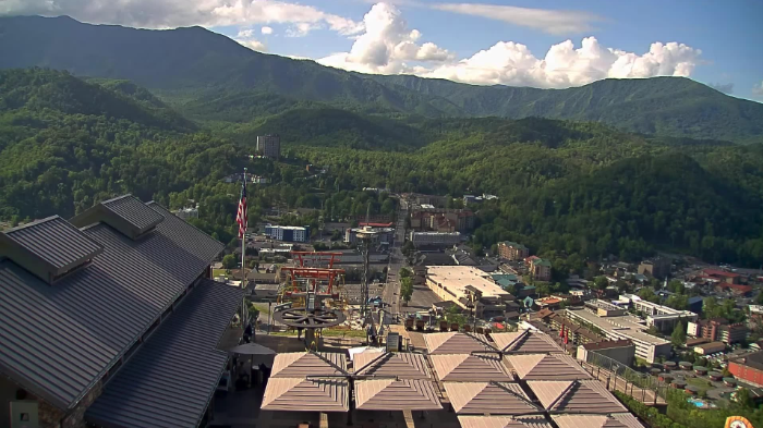 We are in the midst of a very summer-like pattern, where warm and moist air will bring the daily threat for showers and storms. Overall, these will be isolated to scattered in nature, where the bulk of activity will stay in the Smokies and Plateau. That said, we could get some that drift into the heart of the valley, so don't be surprised to get caught in a quick heavy shower or storm one afternoon/early evening. No real widespread rain makers look to be in the forecast for the next several days.  As hinted at above by the lack of meaningful rainfall ahead, our eyes are then focused on the results of this. It's great to have warm and generally quiet days, but this can only be sustained for so long without some issues arising. Looking at the rainfall departure from normal over the past 2 weeks, you can see most areas are running 1 to 2 inches below their typical average. Given some low-end abnormally dry spots creeping in on the drought monitor, I fully expect an expansion of this map tomorrow and next week. The one and only exception to this was our most recent rain maker, where far NE Tennessee picked up above average amounts. We will keep you posted as we move forward, but for now, not too much to worry about in terms of any major drought threats this week.  That will do it for today. It will be an excellent series of days to get out and about. That said, keep the umbrella close (just in case) and keep your heat safety in mind. We will warm to near the 90 mark by Saturday afternoon. UV indices will also remain high all week. Pre-recorded for 5pm weather broadcast
0 Comments
The overall trend through the week will be the rising temperatures and daily isolated to scattered shower/storm chance. Shower activity will primarily be during the peak heating hours of the day (afternoon to early evening) before dissipating into the night. As far as temperatures, we will start in the upper 70s to low 80s today, warming to around the 90 mark by Saturday. Pre-recorded for 5pm weather broadcast
Pre-recorded for 5pm Weather Broadcast
Another pleasant day planned, with mostly sunny skies and highs finding the low 80s. As you can see below, clear skies are in full force heading into the lunch time hour with traffic at the intersection of I-40 and I-75 a little backed up in spots, especially the further east you head towards downtown. 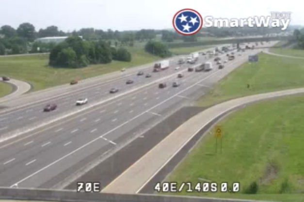 As far as those temperatures, we will be mild today but cooler air is inbound. A passing dry cold front will bring a cooler feel to the area tomorrow and throughout the weekend, aided by additional cloud cover and isolated to scattered rain chances. You can clearly make out the cold front to our north, where much cooler air resides when compared to yesterdays temperatures.  Looking at model guidance, shower chances will vary through the holliday weekend. A system across the Carolinas will actually bring rainfall from the east (a rarity for us). Given the orientation and progression of this system, Northeast Tennessee will be favored for the best rain/storm chances, while locations further south and west fair the best in staying dry. That said, most locations will see an increase in cloud cover Friday night into Saturday, lingering through much of the weekend. Given there are still some uncertainties on path/ moisture/ strength of the weekend system, have stayed close to the 20-40% range for rainfall chances Saturday and Sunday across the valley. Better and warmer conditions are likely Memorial Day.  That will conclude todays forecast, I hope you are able to get out and enjoy some sunshine and mild temperatures. The 70s and even a few 60s for highs are expected this weekend. We warm right back up next week, with near 90 on the horizon for some! Pre-recorded for 5pm weather broadcast
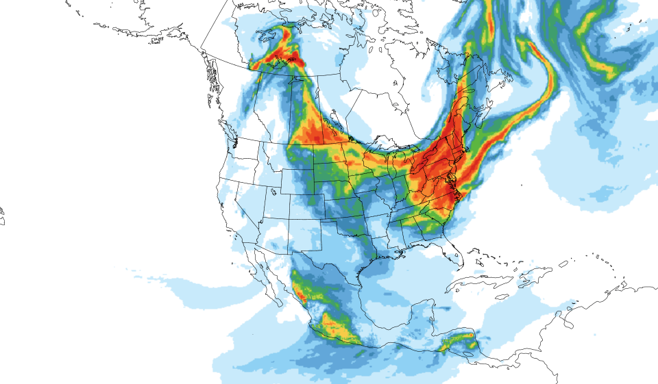
Good morning all! We mentioned this several days ago, but have you noticed the haze in the air? If not, check out this mornings view across the Smokies. No this isn't contributed to the Smoky Mountains because of the name, but actually from smoke all the way in Canada. Large wildfires in Alberta have allowed for smoke to drift into the area and brought the hazy look we see. This can be visualized below (bottom right), where smoke concentrations are across much of the Mid Atlantic and through the Midwest. These will make for good sunset pictures!
In terms of UV, values will be high. Even with the haze in the area, which could limit UV indices a touch and also make temperatures slightly cooler, we are still looking at values between 8 and 10 today. If you do plan to be outdoors for extended periods of time, don't forget the sunscreen! 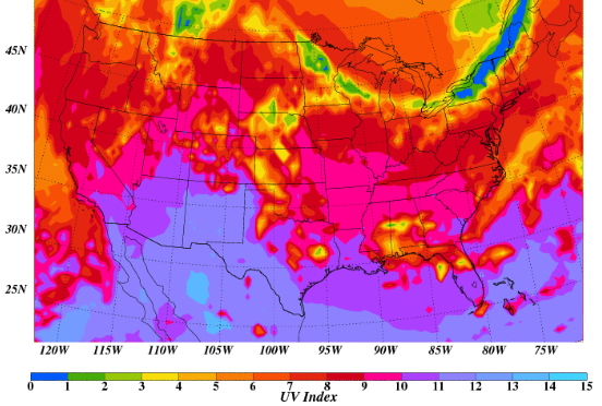 High pressure will keep things mostly dry today and tomorrow, before afternoon to evening isolated to scattered shower/storms will be possible Friday and through the holiday weekend. Temperatures will also cool down a bit Saturday and Sunday, with highs in the low to mid 70s both days. Check out our video forecast below for more. Pre-recorded for 5pm weather broadcast
Pre-recorded for 5pm weather broadcast
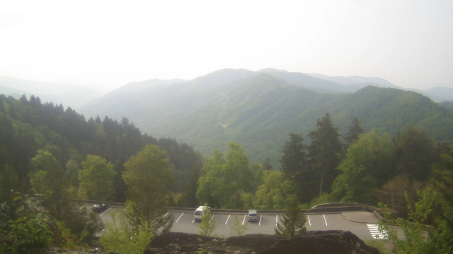
The new work week begins and we will start off with cloud cover and times of sunshine much of the day. Looking at the Newfound Gap cam over the Smokies, mostly cloudy skies are present here but broken skies dominate elsewhere. In terms of highs, we will be a bit warmer than yesterday, topping out in the upper 70s to low 80s today. 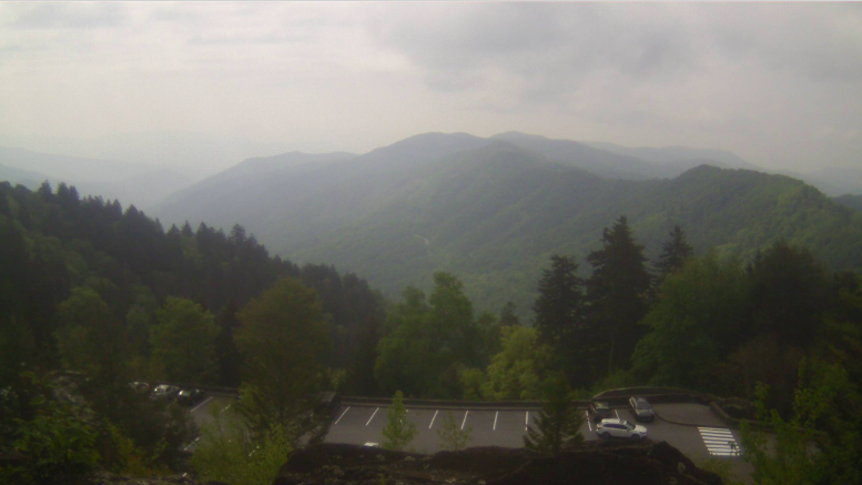 Moving forward, there is not a ton to discuss in detail. A disturbance to our south can be to blame for the cloud cover today and tonight. We will also have isolated shower/storms chances tonight and tomorrow during the afternoon, but chances are very low and limited to the south (Chattanooga metro area). By Wednesday, sunshine returns in full force. Another low end chances (for all) then returns Friday into the weekend.  Checking out the Weather Prediction Center's rainfall outlook over the next week, very limited rainfall is expected. Again Friday into this weekend will be our "best shot" but chances will be low, with mainly our usual pop-up afternoon junk expected. 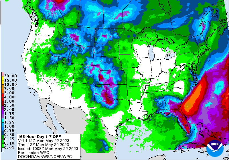 That will wrap it up for today....enjoy the sunshine to come mid week, as well as highs ranging in the upper 70s to low 80s through Friday. Overnight lows will be pleasant as well, generally ranging in the 50s each night. Pre-recorded for 5pm weather broadcast
Good morning! Most areas are running in the upper 50s to low 60s right now (6:30 am) but will climb much warmer by this afternoon. It should be a pleasant one overall, with partly cloudy skies and highs running in the upper 70s and low 80s. Clouds are set to increase by this evening, with a cold front en route. This will lead to showers and isolated storms late tonight into Saturday, with rainfall amounts minimal. Generally a couple of tenths up to a quarter of an inch will be possible through this time tomorrow.  After the passage of the cold front Saturday afternoon, drier conditions edge back in by Sunday. From Sunday through mid week, things look dry and warming. There is some uncertainty in guidance, suggesting a disturbance to bring limited afternoon showers/storms Tuesday or Wednesday, but for now will hold dry during this time. Looking below, temperatures will warm up quite nicely over the next several days. With the front, cloud cover, and showers tomorrow, highs will max out in the low to mid 70s. A quick turn around can be found thereafter, with highs warming into the low to mid 80s by Tuesday, and climbing higher by Thursday.  After this bout of rain it looks to be warm and dry for sometime so take advantage if you can! Saturday may ruin a few outdoor plans, but showers should be out by midafternoon for most. Our dry and warming trend then finds us Sunday into next week. Pre-recorded for 5pm weather broadcast
Pre-recorded for 5pm weather broadcast
|