|
Storms will again impact portions of the area today, as a wavering frontal boundary sits to our north. Based on the Weather Prediction Centers rainfall outlook, northern counties bordering KY could pick up near an inch or more today. Locations south will primary be cloudy, but a few shower/storms can't be ruled out. 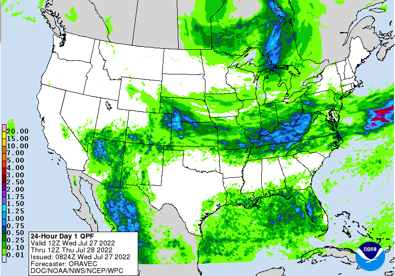 The NWS in Morristown has issued a flood watch for portions of East Tennessee today (view our video forecast below for more details). The WPC has included a Moderate (3/4) risk for flash flooding today as well. This mainly outlines counties bordering KY, but a slight risk remains for the remainder of the area. I anticipate the flash flooding threat to continue to work further south and in higher categories ( slight to moderate) Friday and into the weekend. 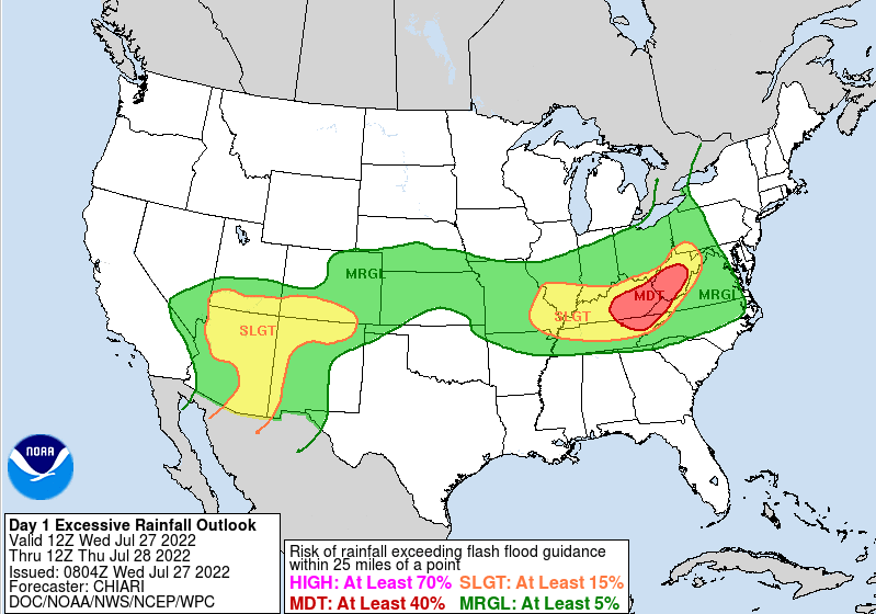 Looking into the future, the frontal boundary will dip southward, bringing renewed opportunities for heavy downpours later tomorrow. A secondary front will also work in, bringing continued activity Friday and throughout the weekend. Based on the latest guidance, this front could set up shop across portions of Tennessee, bringing rounds of showers and thunderstorms as far as into early next week or beyond. This will depend on how far south this works before stalling out. This is all to say, get used to cloud cover and periodical shower/storms, as they look to be in the forecast for the next several days. 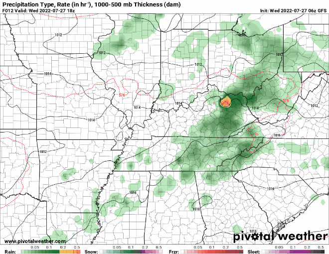 With rounds of showers and storms, flooding will remain a big concern. This is particularly so starting late tomorrow and throughout the weekend (East TN-wide). Areas that see persistent or repeated activity will have the highest risk. Have a way to receive warnings if they were to be issued. Pre-recorded for 5pm weather broadcast
0 Comments
Starting off with a look at the day 2 (Wednesday) flood potential. WPC has placed most of the area under a slight (2/4) risk for flash flooding. The good news is we miss quite a bit of rainfall today, with the much higher amounts across Kentucky. With that said, we will get our turn starting late tomorrow and becoming more pronounced on Thursday. I will emphasize a bit this week that flash flood potential increases each day moving forward, and will be the best potential in slow moving thunderstorms and for areas that see repeated activity. 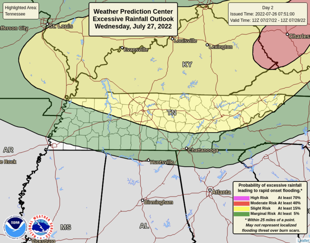 Breaking down one of the larger and more grainy models, showers/storms hang mainly north today, as an upper level disturbances passes through. A frontal boundary remains in place across Kentucky, but will begin to wash out through tonight and into tomorrow. As it does so, a secondary and stronger front will work in toward Thursday, bringing much better shower and storm chances to the area. This will slide into Tennessee, before stalling out across the area. As it does so, rounds of showers and thunderstorms will find us Friday and through the weekend. We will keep an eye on this upcoming boundary, is it could swing further south (good news) or continue to bring lots of rainfall to East Tennessee. Check back in with us tomorrow for more details!  If you have outdoors plans, today and tomorrow will likely be your best time. Though showers and storms will be in the forecast, chances are the lowest (50-60% chance) these two days. Activity will pick up and become widespread by Thursday, and likely, most of the weekend. Rainfall amounts through early next week will range from 4-7 inches. Flooding will be a concern all week, especially into the weekend. Pre-recorded for 5pm weather broadcast
We will start off saying: Keep your umbrellas very close by this week! An active stretch of showers and storms finds us starting today and continuing through at least Saturday. Because of the pattern, flash flooding will be a major concern this week. A slight risk was introduced for today, as showers/storms become widespread this afternoon. Heavy downpours and repeat activity will lead to instances of flooding across the area. This threat will continue to increase in the days moving forward, so have a way to receive any watches or warnings if they were to be issued. 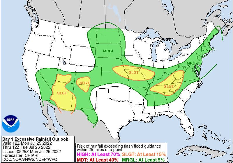 As far as how this plays out, a frontal boundary will hang just to our north, allowing for showers and storms to develop off of. This hangs around through tomorrow, before lifting north as a warm front Wednesday. A secondary boundary will then find the area Thursday, bringing renewed chances through the end of the week and into the weekend. The severe threat overall is low, but not entirely ruled out. Strong storms will be possible during the afternoon hours each day, with gusty winds the primary threat. 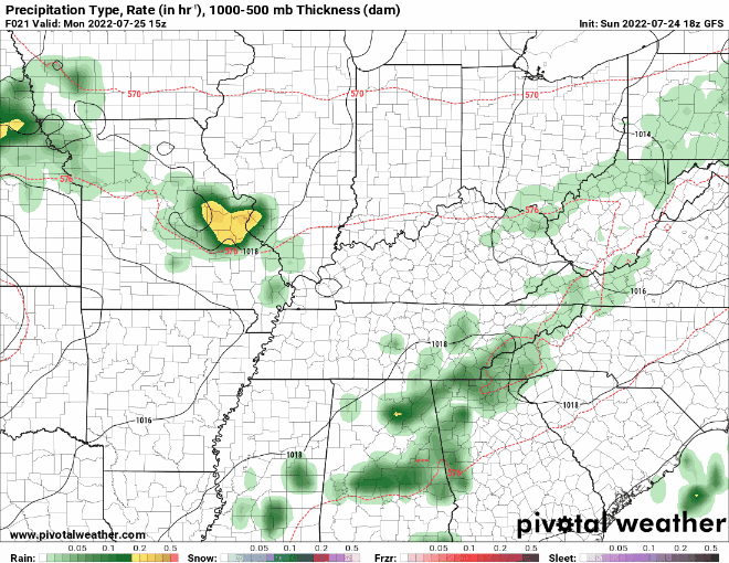 Rainfall amounts overall will vary. Some will see much higher amounts than others, but on average, 4-5 inches can be expected over the next 7 days. With pretty saturated soil conditions already, it won't be hard for flooding to occur. As mentioned, the threat of this rises each day for areas that see continued or persistent activity. 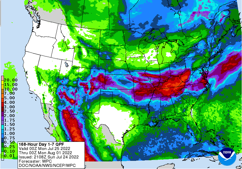 A wet pattern can be expected this week, with several rounds of shower and storms anticipated. Let us know if you are seeing flooding and/or rising waters, so that we can share that with other viewers as well as the National Weather Service. Have a good one, stay tuned for further updates, and do your best to stay dry this week. On the plus side, temperatures will be a bit cooler than the low and mid 90s! Pre-recorded for 5 pm weather broadcast
A pleasant start to the day, as current (8 am) temperatures range in the upper 60s to low 70s. Take advantage of the mild start because changes are coming. Also use caution if you are heading out this morning, as dense fog is showing up across the area. Before taking a dive into the forecast, a look at the latest drought map. There has been both some improvement, as well as some significant decline. Across East Tennessee, most areas are blank (or running normal), while West Tennessee is in some serious need of rain. Well below average rainfall through June and into the first half of July has led to a very depleted moisture levels. As such, severe drought has expanded through most of the area. 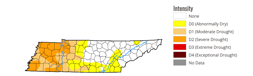 The current drought map 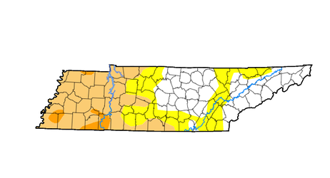 Last weeks drought map Moving forward, very warm temperatures will find the region. These could be the warmest days we have seen so far this year. The positive part of this news is it's going to be a drier heat. Highs are expected to top out in the low 90s today, followed by low and mid 90s tomorrow and Sunday. Dew points will increase through the weekend, leading to heat indices in the low triple digits by Sunday afternoon. It could be much worse, so we'll count our blessings, but definitely keep your heat safety in mind the next few days.  Looking at a recap of Wednesday night, a nearly stationary storm across portions of Oak Ridge, Clinton, Powell, and North Knox dumped significant rain. Flash flooding was a major concern in this area, as radar estimates of 6-8 inches were seen. Looking below, you can see the 24-hour rainfall amounts associated with the storm, then followed by the large storm complex (from Central KY) a few hours later. Thankfully we have dried back out and will continue that trend into the weekend. 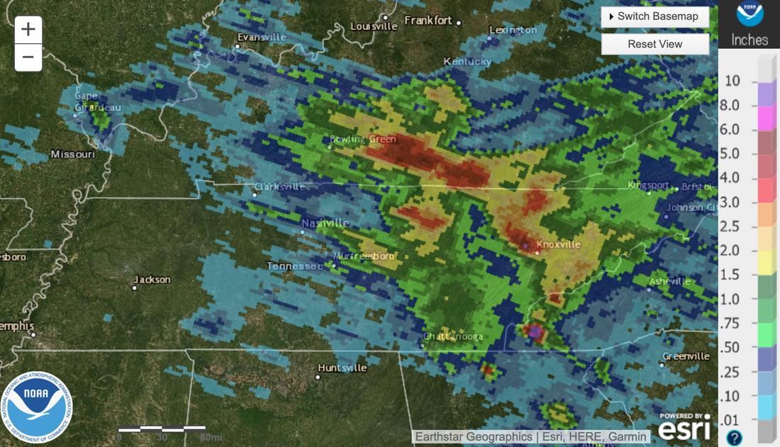 With that said, showers and storms return late Sunday night and into the day Monday. A frontal boundary looks to stall out across Kentucky, leaving us with the chance of showers & storms each day next week. These will be hit and miss, with the best opportunity during the afternoon hours. Another frontal boundary then looks to press in later in the work week. Overall, warm and dry this weekend, then pretty active next week with rounds of rainfall. Pre-recorded for 5pm weather-cast
Pre-recorded for 5pm weather-cast
Full forecast below, but highlights include: - Showers and storms at times tonight (some of which could be stronger) - Warming temperature trend the next several days Good afternoon! Starting off first comparing temperatures to this time yesterday, we are a bit cooler. A frontal boundary washing out across the area will provide temperatures near average this afternoon. Unfortunately, from here on out an upward trend can be expected. 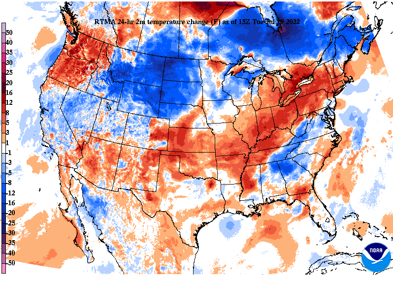 Providing my thoughts on this weekends heat wave....an upper level ridge has been present across the Southwest (in general) for the past several weeks. As an upper low works east and out of the area, surface high pressure will fill in across the eastern CONUS. Looking at height anomalies, or rarity, there is nothing that really sticks out. Further more, we are not coming into this weekend super dry (like the month of June). All of this leads me to believe it will be warm (no doubt) but nothing close to record setting. Record highs for this Saturday (the 23rd) are both at 101 for Knoxville and Oak Ridge. The current forecast calls for mid 90s in the valley and low 90s in the plateau. This will be a good weekend to chill out in the pool, lake, or inside.  Turning our attention back to today through the end of the work week, the subtle boundary will lead to isolated and scattered showers/storms today and the next couple of days. Once this finally presses through and out late Thursday, high pressure will fill in. Because activity is quite "random" it will be hard to say exactly who sees showers/storms each day. Welcome to a typical summer afternoon, right? The good news is chances will be fairly low each day 20-40%. Dry conditions return Friday and the weekend.  Other than a few showers & storms each day through Thursday, the main focus is on the encroaching heat. Highs will continue to warm each day, peaking in the low to mid 90s by the start of this weekend. Check out our video forecast below for more information. Pre-recorded for 5pm show
Showers and storms are beginning to work their way in early this afternoon. Keep in mind even though the severe threat is low, a few storms could be strong- dumping heavy rainfall as well as providing gusty winds. A low end chance for flash flooding is also in place. Activity will begin to lessen overnight tonight, as a frontal boundary washes out across the area. 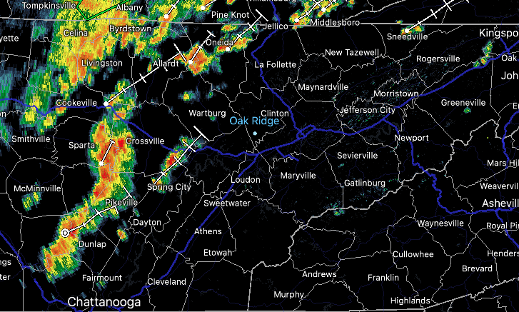 Because of this boundary, shower & storm potential will stick around through at least mid week. Towards late Thursday and into Friday, high pressure fills in bringing drier but warmer conditions. The good news is, rainfall won't be as heavy as what we have seen north of us. Some areas of Kentucky have picked up over 2.5" of rainfall since midnight this morning. Generally, around an inch of rainfall is expected area-wide through today/tonight. From thereafter, shower/storms will be isolated to scattered and mainly during peak heating (afternoon & early evening).  By the end of the work week, high pressure and southerly flow will boost temperatures right back up above average. Highs will range in the low, and for some, mid 90s. Looking at temperature anomalies, we will top out anywhere between 5 and 10 degrees above average. This trend looks to continue throughout the weekend as well. 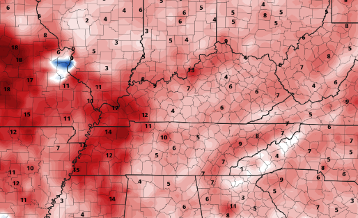 Overall, some much needed rain will find us today, with scattered activity each afternoon through mid week. Drier but warmer conditions then return late Thursday, Friday, and into the weekend. Pre-recorded for 5pm show
Little change from yesterday in terms of what can be expected weather-wise today. A stray shower or storm is as good as it gets, but temperatures are a touch warmer and muggier. Looking at the 24 hour temperature change map, you can see we are warmer than 11 am yesterday. High pressure will continue shifting east, pulling in warmer and muggier conditions. 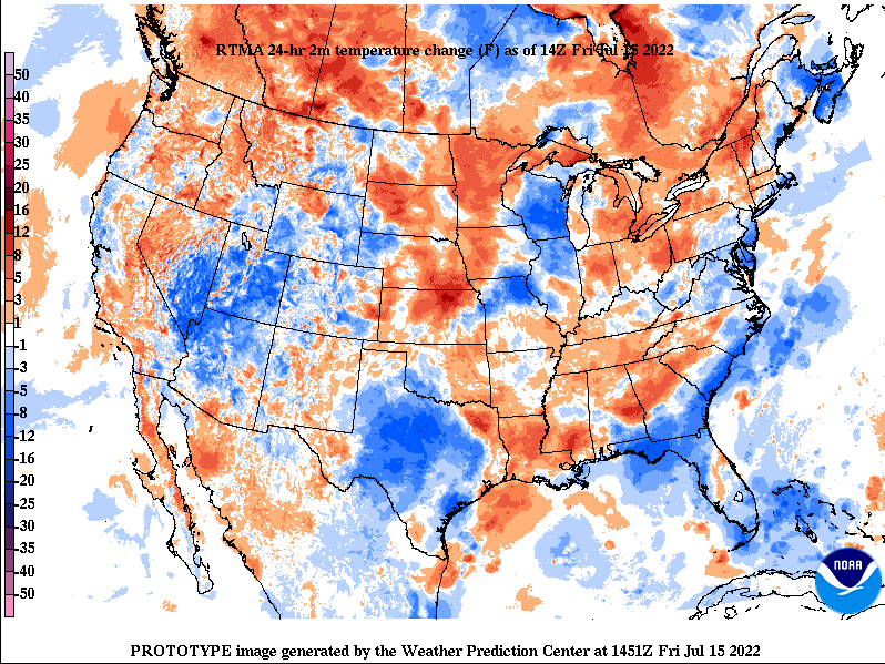 A cold front is also slowly on the way. This will arrive early next week, bringing widespread showers and storms Monday and early Tuesday. Leading up, the warm and muggy conditions will lead to a stray shower/storm today and tomorrow, before becoming scattered on Sunday. A few storms through early next week could be strong, with heavy downpours and gusty winds the main threat. We are still in need of rain across the area, so we will welcome the activity on Monday.  Looking towards the end of the month, a shift back to above average temperatures and near to slightly below average rainfall looks to find us. The end of July will generally be similar to today, where temperatures peak in the low 90s and afternoon pop up showers and storms will be possible each day.  Overall, the weekend will be fairly quiet but warm to start. Sunday will give way to better shower and storm chances, followed by the best opportunity on Monday. Cooler temperatures (mid to upper 80s) will be present, before warming and drying back out towards mid week. Have a good weekend, and don't forget to give us a follow @SecretCityWx Pre-recorded for 5pm show
As expected, conditions have improved across the eastern half of the state. Unfortunately, the same can't be said across the west. Comparing the current map to last weeks (bottom), you can see small areas of severe drought have inched their way elsewhere. This will be something to continue monitoring, especially as rainfall continues to look on the lower end for these locations. On to the good news, East Tennessee is beginning to recover nicely. After multiple rounds of rain, some of which were very heavy, normal to abnormally dry conditions now dominate the area with continued improvement likely by next week. 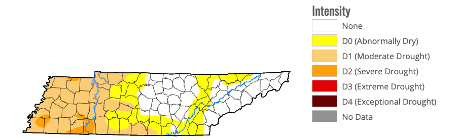 Current Drought Map 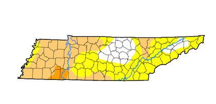 Last Week's Drought Map In terms of rainfall ahead, high pressure is in place and will remain so through tomorrow. This isn't to say an isolated shower can't pop up across the Smokies, but most will stay dry and warming. As we work into the weekend, muggier conditions find us, leading to the opportunity for afternoon pop up showers and storms during the afternoon. The chances are low, but not ruled out each day. By Monday, a frontal boundary will be nearing the region, bringing much better potential early next week.  Take advantage of these conditions, highs are near to slightly above average today and tomorrow, before muggier conditions find us Saturday through early next week. Check out our video broadcast below for more. Pre-recorded for 5pm show
|