|
Good evening! I hope everyone enjoyed their Thanksgiving and brief break. A look ahead shows a quickly evolving "winter-like" system working across the region. The latest radar single shot has light to moderate rainfall working through much of East Tennessee overnight. For those seeing this Monday morning, some light showers are likely out of the door but a dry wave will arrive mid-morning to early afternoon. 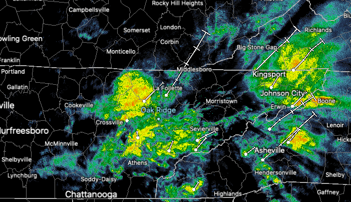 Looking at the temperatures the past 24-hours, you can see where the much cooler air sits. A trailing cold front from the low to our south will funnel through midday tomorrow. Not only will it bring snow chances but also the coldest temperatures we have seen since the beginning of 2020. High's Tuesday will be in the 30's with overnight low's in the teens (for some) and 20's (for most). 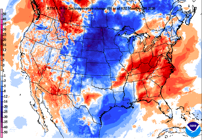 As mentioned above, an area of dry air will arrive mid-morning to early afternoon (chilly & windy during this time) before the transition to snow showers works across the region. As seen below, snow showers are likely across East Tennessee but totals look very limited, at least here in the Valley. Walking through what you can expect now through Tuesday morning, showers will fulfill much of tonight. By the morning hours of Monday, showers will be limited with a period of cloudy skies. During this time, temperatures will continue falling through the day leaving mid 30's for the evening commute. High's for the day will come Monday morning near the mid 40's. As of now, the transition time to snow will take place sometime between 4 pm and 8pm. Of course the Plateau and regions to the west will see the transition sooner than the Valley, the entire area will likely see some flakes falling tomorrow evening/night. 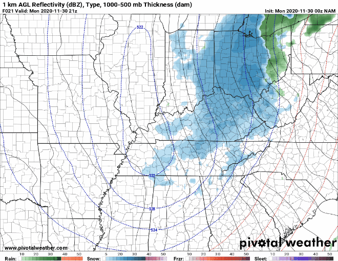 In fact, the Valley will more than likely see some flurries to a dusting of snow. Depending on the transition time and how much moisture is wrapped in behind the low, some areas could see up to half an inch (leaning on the lesser amounts). Outside of the valley though, the highest elevations of the Smokies could see upwards of a foot. For the populated areas of the foothills anywhere from half an inch to 2 inches is possible with higher amounts as you work east. To our west, the Plateau should see anywhere between half an inch and 2" with the highest peaks seeing locally higher amounts. Overall, the Valley looks to get the short end of the stick (as usual). This isn't all bad though as travel conditions in these locations will likely be safer than those with higher snow amounts. Even with that said, patchy ice will be possible Tuesday morning. Heavy winds tomorrow should do a good job of evaporating a lot of the road surface moisture but still be weary into Tuesday morning. 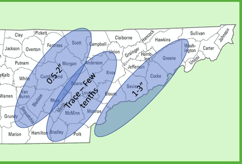 Be sure to tune in for updates Monday (especially the second half of the day). As of now, we are not expecting a major impact to travel here in the valley but things can always change with these winter events. Stay dry, especially if you are still out and about tonight, and definitely stay warm as strong winds and cold temperatures will funnel in throughout the day tomorrow.
0 Comments
Happy Thanksgiving Eve! Cloud cover will continue increasing today as a strong front will work across the area. The SPC (Storm Prediction Center) has extended the Marginal Risk for severe storms to include parts of East Tennessee this afternoon and evening. Timing continues to be later into the afternoon and early into the evening (the commute timeframe). 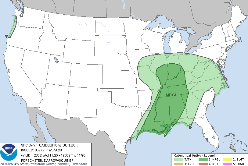 A look at what model guidance is suggesting, we'll see strong showers and a few storms start in Western Tennessee and continue eastward, slowly weakening as they move. Depending when these storms fire up will give us an idea when we can best expect the line of showers/storms to move across our area. Assuming a quicker arrival time (as suggested more recently), I anticipate showers/storms to hold a bit more strength. This means gusty to damaging winds, heavy downpours, and lightning are possible this evening. Total rainfall accumulations will vary throughout the area as pockets of storms will provide heavier totals. In general, a nice bed near half an inch will be possible given the likelihood for stronger showers. Be sure to check in for updates this afternoon and evening.  The good news with this system tonight is we'll clear out quickly, allowing for a gorgeous Thanksgiving. As you can see below, your Turkey Day forecast will include lots of sunshine and high's in the mid 60's. Though this doesn't set any records, it will be an above average day. Knoxville typically averages high's in the upper 50's for Thanksgiving so enjoy this mild weather. 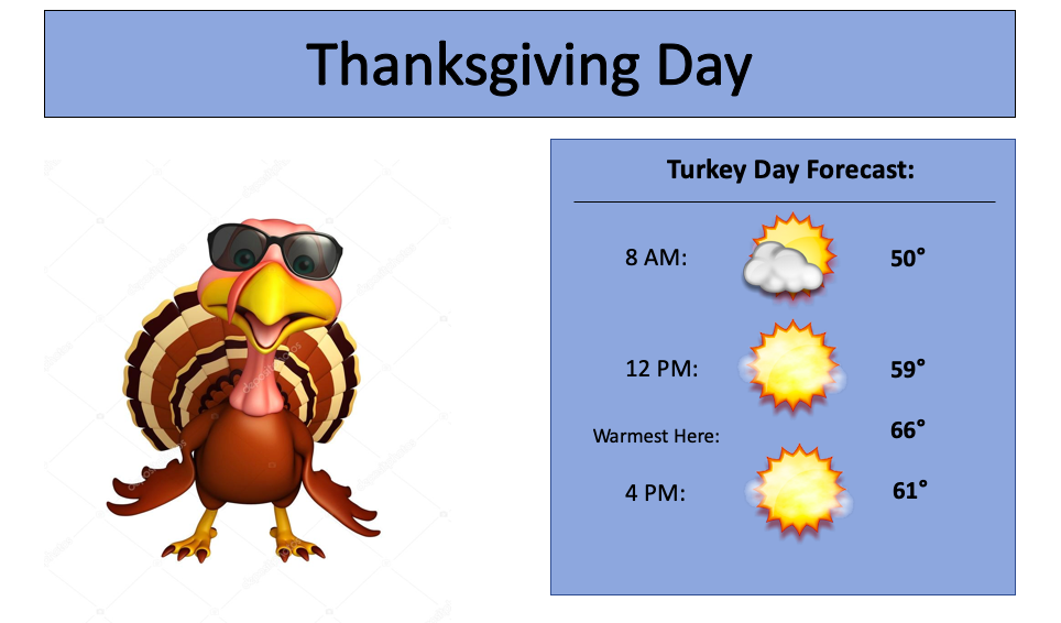 Be weary of strong to isolated severe storms later this afternoon and evening. We'll see clearing in behind this followed with beautiful conditions for Thanksgiving. A sneak peak longer term shows the chance for a few flakes (don't get too excited) later in the forecasting period. We'll highlight this ahead, but for now, stay safe and have a wonderful Thanksgiving! We begin this Tuesday with a gorgeous view from Clingmans Dome. Current temperatures in the valley lie in the mid to upper 30's with a few high clouds overhead. Anticipate increased cloud cover towards the overnight hours tonight as a system will work in for your Wednesday. High's today in the upper 50's. 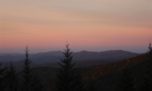 Looking ahead, there is the system I am referring to. Bringing all weather phenomena from snow, ice, and rain, it will move east through the day today arriving to East Tennessee by the second half of the day tomorrow. Though we won't see snow for some time, prepare for some rainfall in the evening to overnight hours tomorrow. The SPC (Storm Prediction Center) has issued a Marginal risk of severe storms from Middle Tennessee and west. This will be the best area to watch for gusty winds, heavy downpours, and lightning. Given the current timing, showers & any storms will weaken as they work east (good news here at home). 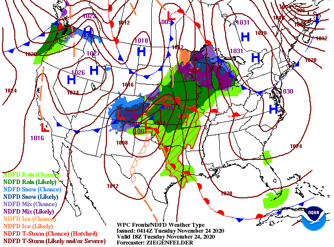 Taking a look at model guidance, things stay dry overnight tonight and early Wednesday. By the late-morning to early afternoon, a few could see an isolated shower, otherwise things stay cloudy. For the evening though, showers begin working in from the west. As you can tell, this line of showers/ isolated storms begins breaking down once it moves through Middle Tennessee. Rainfall will be similar to our last system with upwards of a quarter of an inch possible (locally higher amounts possible).  The all important Thanksgiving forecast looks beautiful with improving skies through the day and high's very mild in the mid to upper 60's. Thanksgiving will likely be our best day Wednesday through the weekend, so enjoy the holiday! A great Monday morning to you! With the passage of a cold front last night, much cooler air has pulled in and we'll see that this afternoon. High's are expected to only top out in the low to mid 50's, so stay warm. A look at the latest surface map has an area of high pressure just to the west followed by another weather maker in behind it. Things stay dry and mostly sunny today and tomorrow before rain returns Wednesday. 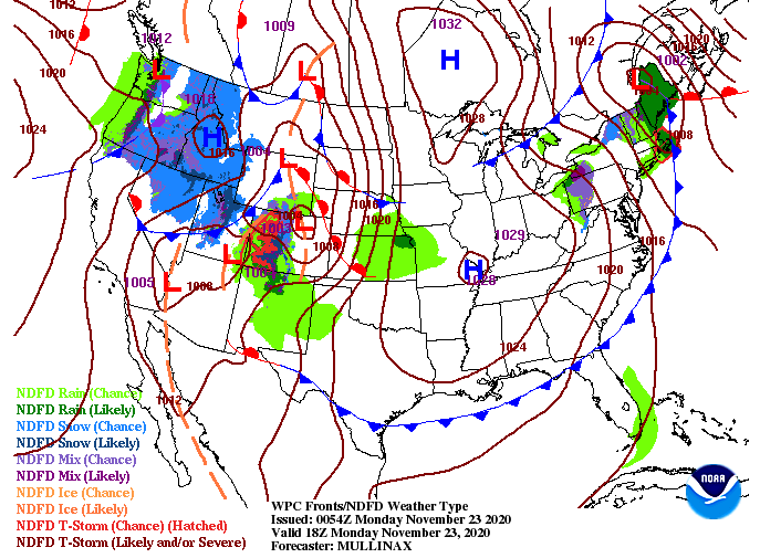 Similar to what we saw last night, a line of showers will arrive the second half of the day Wednesday. At times, we could see some heavier rainfall and a few lightning strikes but any severe potential will be very limited and to our west. The good news is we'll see improving conditions by Wednesday night, just in time for Thanksgiving! If you have plans with friends or family, things look very pleasant and dry on Thursday.  Overall, rain totals into Thursday morning will be varied from 0.5" to 1.5". Heavier pockets of rainfall will of course equate to heavier totals in some areas. The positive with this is the need for moisture across the state. We have been trending dry this month and even have abnormally dry spots popping up across the region. Hopefully a fresh bed of rainfall will keep things just wet enough for any new drought related conditions to spawn up. 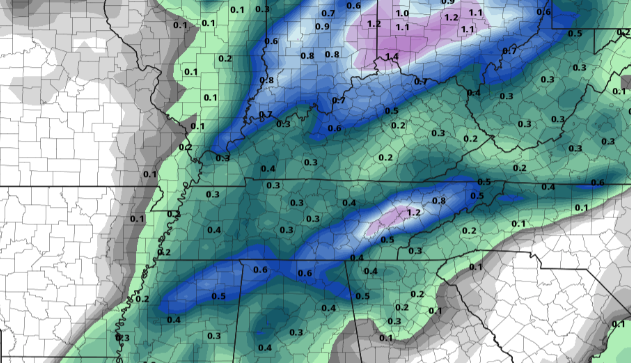 Sky conditions will continue improving this morning leaving sunny skies this afternoon. Stay warm though, high's will be below average in the low to mid 50's. Longer term, things look to be above average to round out the year (full details below). The latest drought conditions across Tennessee have been right at normal for several weeks, but a slight change has arrived. Southwestern TN is seeing some abnormally dry conditions developing as we have picked up limited rainfall throughout November. As we work ahead, we'll keep a close eye on the potential for abnormally dry conditions to increase across the state. Activity will be thin now through Thanksgiving, before we could see heavier rainfall potential late this next week. 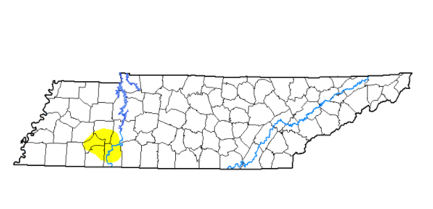 If you have enjoyed the weather across East Tennessee this week, it looks to continue again today and into Saturday. High temperatures will also continue increasing with temps today in the mid 60's and upper 60's tomorrow. Rounding out the weekend on Sunday, cloud cover will increase through the day as a cold front brings isolated showers overnight. Similar to the last system we had, moisture potential fades as we work into the overnight hours. This means the northern half of East TN has the best potential for any rainfall, and at that, we are expecting up to a tenth of an inch at best. Clearer and cooler conditions find their way back for the start of the work week, Monday.  The latest trends from the CPC don't look promising (Fall-wise). Well above average temperatures are more than likely in our future for not only Tennessee, but the entire eastern half of the US. The latest trends in data show the likelihood for a "delayed winter" here at home. Temperatures will more than likely be normal to slightly above normal through December and parts of January before a colder pattern sets in later in the season. This isn't to say we won't have cold spells or potential snow events in our future, but we'll likely see the coolest temperatures the second half of the season. 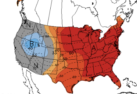 It'll be another pleasant end to the work week today, so get out and enjoy the picture perfect conditions. Don't forget to share your views across East TN as well by sharing on Facebook, Twitter, or through email. Have a great weekend and prepare for another cooler shot of air next week. Good Thursday morning! It's another chilly one with current temperatures in the lower 30's but an improvement from Wednesday morning where we started the day in the upper 20's. As we progress through today, anticipate some warmer temperatures. As you can see below, the bulk of warmer air will linger to the west today as high pressure moves east overhead. As we round out the work week, high's will continue to increase toward the mid 60's and eventually upper 60's for Saturday. 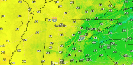 With an area of high pressure sitting just to our east Friday and Saturday, things stay dry, sunny, and warming. By Sunday, a low to the north will bring the potential for isolated showers late into the day and into early Monday. As we saw with the last round of showers, moisture begins dying out as it works eastward. With that said, some areas across East Tennessee will pick up anywhere between a trace and 0.15" by Monday morning.  A cold front will also follow this line of showers Monday morning, leaving high's to begin the new work week back into the upper 50's. That will wrap it up for today, but as always, thank you for supporting Secret City Weather! Don't forget to give us a follow on Twitter & Facebook (@SecretCityWx). The "bad" news is today will be the coolest day we'll see this week. However, on the flip side, a warming trend will follow. For this afternoon, much of the valley will see high's in the lower 50's with a few spots reaching the mid 50's (specifically the southern half of East TN). As we work ahead, southern flow will allow for high's to return to average and slightly above average for this time of the day. 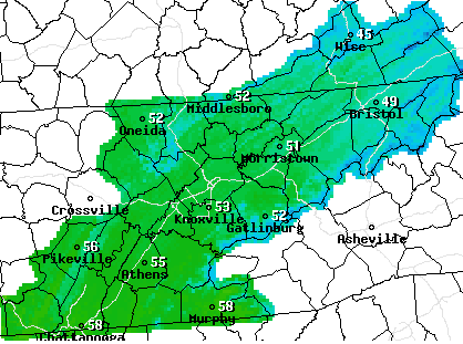 A look at the surface map for this afternoon shows high pressure working east. Due to the nature of high pressure, anti-cyclonic flow will generate winds out of the south. This means temperatures will begin rising back up in the days ahead. In addition to the slowly rising high's each day, tons of sunshine will continue to stick around for the next several days. 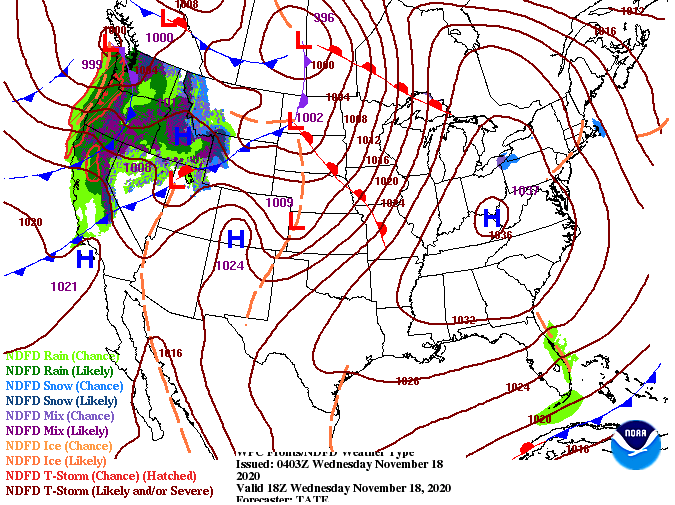 The next chance for rainfall doesn't come until late weekend. A weak system is expected to provide cloud cover Sunday afternoon and isolated showers overnight and into Monday. For now, things will stay beautiful across the state with warming temps Thursday through Saturday. A beautiful and chilly morning is upon us looking across the Smokies from Clingmans Dome (below). Temperatures here in the valley are in the mid 30's and will slowly warm to a high in the mid 50's under sunny skies. 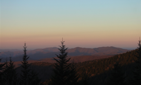 As we work back overnight tonight, things again cool off quickly. The coolest temperatures of the week are expected overnight tonight with a low in the upper 20's for most. Cool temperatures continue for Wednesday with high's in the low to mid 50's, then a warming pattern takes over. East Tennessee will slowly build back temperatures with high's by Friday in the mid 60's. 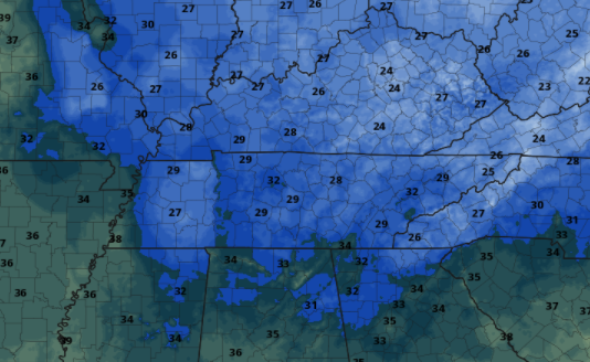 Again today, little activity is in the forecast. High pressure continues to dominate the eastern half of the US providing tons of sunshine and below average temperatures for the first half of the week. As the area of high pressure works eastward, return flow will allow for warmer air to push into the region Thursday through the weekend. Longer term, we could see some limited shower activity late into the weekend and early next week, otherwise things stay dry and pleasant the next several days.. 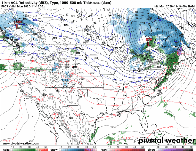 Thank you for being a viewer of Secret City Weather! We really appreciate your support and if there is anything we can help you or your business with, let us know through email [email protected]. Have a great day and take advantage of these Fall conditions. With a very common Fall cold front working through the region yesterday, we saw some pretty strong non-severe wind gusts. Most areas in the Valley averaged 30 to 40 mph but Cove Mountain took the cake with a gust of 86 mph. Camp Creek gets silver with a wind gust of 71. The good news is winds have died down overnight, giving way to cooler air and sunny skies as we work toward the afternoon today. 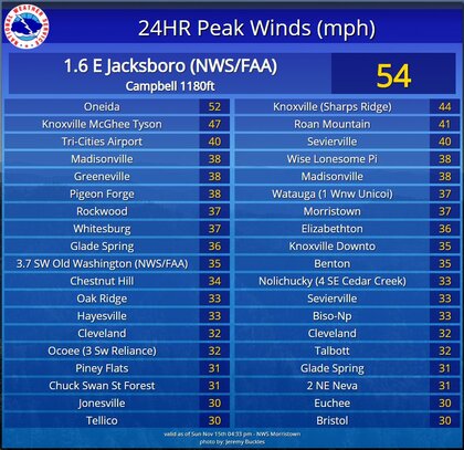 A look at the surface map shows a high to the west. Because of its clock-wise flow, cooler air will continue to usher in from the north the next couple of days. Wednesday will more than likely be our coolest day before temperatures begin building back up.  With a high in place, there is really little to talk about. Much of the eastern half of the US stays dry for much of this week with a strong low riding through Canada bringing snowfall. Here at home, we will stay below average through Wednesday before temperatures find their way back into the 60's the second half of the week. Sunny skies will be the main story overhead, so take advantage of another week of beautiful conditions (this time on the cooler side). If you have missed these cooler temperatures, make the most of them! Things stay cool the next couple of days before we begin creeping back up towards 70 degrees. Have a good start to the new work week and stay warm! Things have started crisp and cool and will turn out to be beautiful as the day progresses. Temperatures will be right around the average (low to mid 60's) under sunny skies. An update on the Tennessee drought map shows average (normal) conditions across the state (good news for this time of the year). 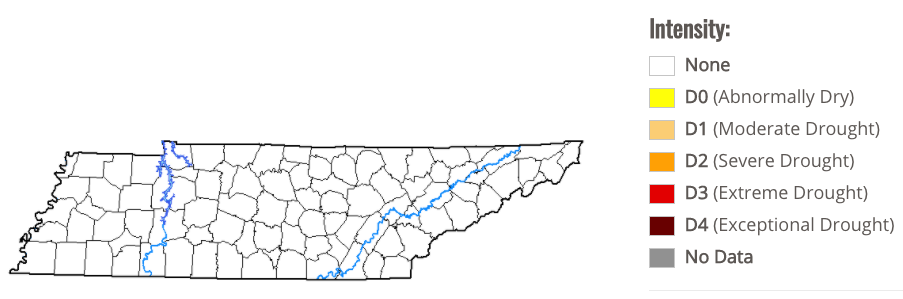 As we make a push towards the weekend, things stay pleasant for Saturday with high's in the mid to upper 60's. A few clouds will work in by the evening hours as a front to the west draws near. As we get into Sunday, a thin line of light showers will find its way in. The bulk of activity will be for the northern half of East Tennessee with amounts up to 0.1 inches. This will be a quick moving system but what follows is the main story.  Temperatures to begin the day Monday will be in the mid 30's and won't increase too much throughout the day. The long wait for that "Fall feel" is finally over as a strong front (depicted below) pushes across the region. Temperatures will stay below average the first half of the week before a warming trend once again returns towards the middle part of November (more details in our daily video below). 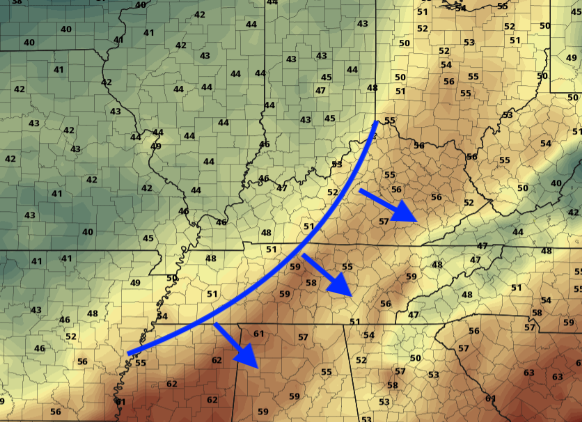 Enjoy a beautiful end to the work week as well as the first half of the weekend. A few showers are possible Sunday, but don't let this dampen your day as they will be quick moving with little impact. Our main weather focus comes next week as a secondary blast of cold air returns. Have a great weekend! |