|
Showers have worked out this morning leaving the majority of us under overcast skies. The good news is high pressure is wedging its way in, which will provide clearing throughout the day. Some sunshine is expected to return this afternoon with high's in the upper 60's. 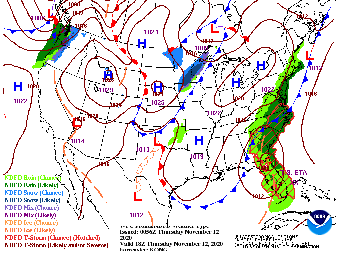 Model guidance is picking up on some of the showers to our east before dry air and sunshine fill in this afternoon. The dry stent continues in through Friday and Saturday before another cold front plows through. This second one, arriving late Sunday, will bring much cooler air into East Tennessee. If you are sick of the record setting high's we have seen this week, you are in luck. We anticipate to start the new work week with high's struggling to find the upper 50's for most. For a change, this will be below average for this time of the year. Knoxville averages high's in the lower 60's for early to mid November. Along with the cooler air to follow, we could see a few sprinkles Sunday afternoon, otherwise the majority of us will stay partly cloudy.  That will do it for today...enjoy improving sky conditions this afternoon as well as some slightly cooler temperatures. Sunny skies will return in its entirety tomorrow and Saturday before a true Fall-feel returns early next week.
0 Comments
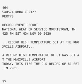
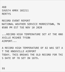
Happy Veterans Day to all who have served or are serving our great country! A look at weather so far this week, things have been hot (for November). How hot have things been lately? Record setting! Monday we saw a high of 81 in Knoxville, this ties the old record of 81 set in 2005. Yesterday, we squarely beat that getting to a temperature of 82 in Knoxville. This beats the old record of 78 degrees, which held on for more than 140 years (1879)!! As for today, shower activity continues into early this afternoon as a cold front migrates through the region.
Rainfall will begin dying out this evening and overnight as high pressure builds in from the west. Cloud cover will decrease through Thursday, giving way to some sunshine by the afternoon. With a cold front working through, we will see some cooler temps but overall, high's stay above average. Longer term, dry conditions stick around Thursday through Saturday before isolated shower chances work in Saturday evening and parts of Sunday. Moisture will be limited with this, leaving most (if any) rainfall to the northern half of Tennessee and into Kentucky. 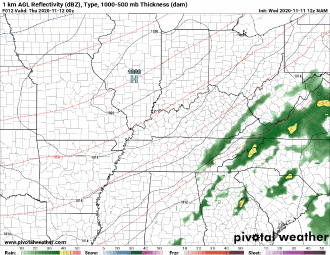 Along with the isolated shower chances will be a strong cold front. The latest data suggests high's returning to the mid 50's Monday afternoon and the cool air continues into the midweek timeframe. This will all be accompanied by sunny skies overhead. 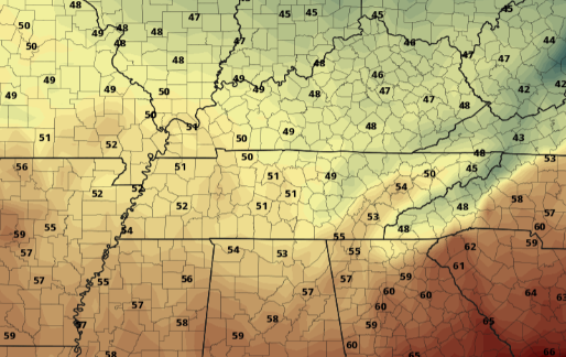 For now, stay dry through this afternoon as moderate showers work in a north-northeast direction. Things will die out overnight, leaving clearing through Thursday and high's in the low 70's. For those eager to see a true "Fall" return, we will have that chance for the start of the work week next week, be patient! Things once again start off with warm temperatures and sunny skies. Changes are in store this week though, as some much needed rainfall arrives midweek. A low to the west is providing rainfall and even snow to parts of the Midwest today. This system will meander eastward, arriving tomorrow night and throughout Wednesday. Unfortunately, if you are a fan of cooler weather, you will have to wait some time. Temperatures will stick to the 70's much of the work week with mid to upper 60's arriving Friday and parts of the weekend. 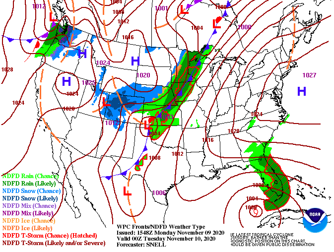 Taking a glance at model driven data midweek, scattered showers will begin settling in Tuesday night. Activity will be on and off throughout the day with heavier pockets of showers Wednesday night. Isolated to scattered showers continue into Thursday morning before a gradual clearing takes place the second half of the day. Sunshine will make a return along with slightly cooler temperatures Friday and most of Saturday. 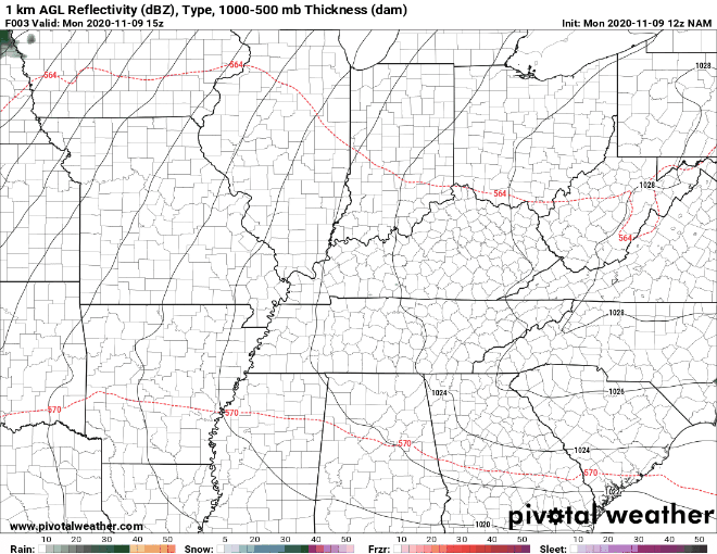 An update on the Tropics shows what's left of Eta working off the Florida coast and into the Gulf of Mexico. It is uncertain if this will restrengthen into a category 1 hurricane in the warmer Gulf waters, but time will tell. What is known is the likelihood for this storm to work back north and eventually east late in the week. With Eta making such a slow progression this week, I would not be surprised to see it strengthen some in the days ahead. Time will tell and we'll keep you updated on the latest. 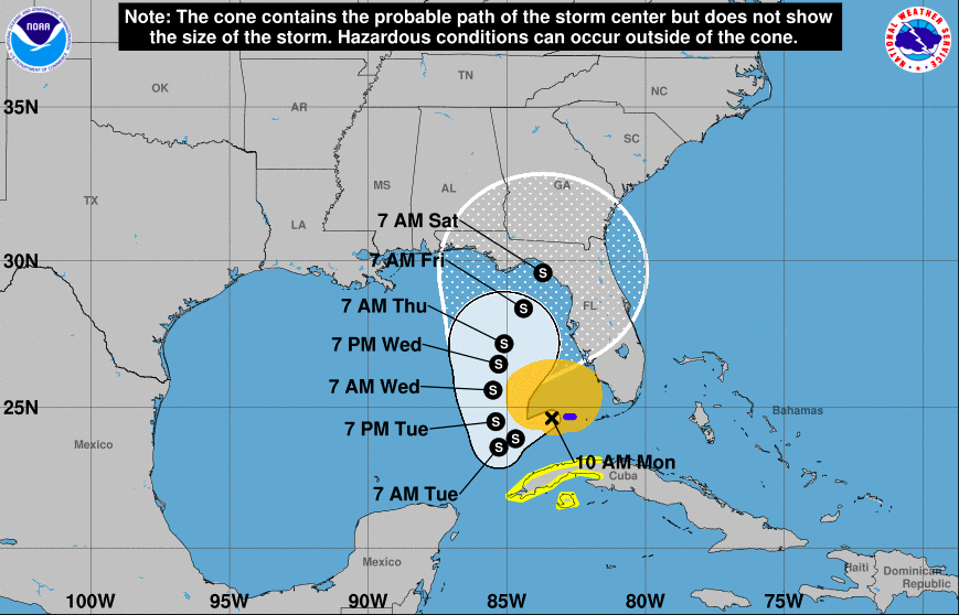 For now, kick back and relax. Enjoy the warm temperatures for this time of the year along with sunshine over head. Some showers will be in the mix midweek, otherwise things clear back out late Thursday and Friday. Have a great week! Friday is here and it'll be a beautiful one! A few lingering clouds and areas of patchy fog are present on satellite now, but things look to clear quickly as the sun continues to rise. An update for Eta shows the system strengthening back to a Tropical Storm and holding that strength through Cuba. By late weekend and early next week, Eta will face a dense high pressure system to the east, forcing the Tropical Storm westward into the Gulf. Given what we know now, it is unlikely to directly hit central Florida on Monday. The more likely result is Eta grazing the state bringing gusty winds and rainfall before landing in the Gulf. 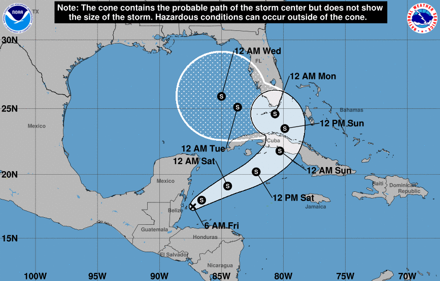 Here at home, things remain the same. A high pressure system to the east is providing some return flow across the region. This is what's providing the warm temperatures we will continue to see this afternoon and through the weekend.  Specifically Saturday and Sunday, high's are expected to top out in the mid 70's with some areas (middle TN) nearing 80 degrees. Though this will likely feel pretty comfortable for most, this is very much above the average for this time of the year. Knoxville averages high's in the mid 60's for this time in November and the heat looks to continue into early next week before rain chances pick back up.  Make the most of these great conditions if you have the chance! Hiking, hunting, camping, or even a little walk around the block couldn't hurt. We will continue to monitor Eta through the weekend as well as keep you up to date on when rain chances return to East Tennessee. Have a great weekend! Pre-recorded for 5pm show
A good Thursday morning to you! A few areas of patchy fog are present, otherwise the majority of us are sitting clear. As we work through the day, a bulk of mid to high level clouds will work in. Don't anticipate these to stick around too long though as sunshine returns to end the work week.  With relatively little to discuss here as home, how does the rest of the U.S. fare? If you recall, Hurricane Eta made landfall in Central America earlier this week as a category 4 storm. This system is expected to hook eastward and push back into the Atlantic tomorrow. Depending on how it responds and how much of its structure is intact, this will give us an insight on the potential for strengthening. As of now, Eta is expected to stay at Tropical Storm strength and work through Cuba and eventually parts of Florida by early next week. Tune back in for updates in regards to strength and path with Eta. 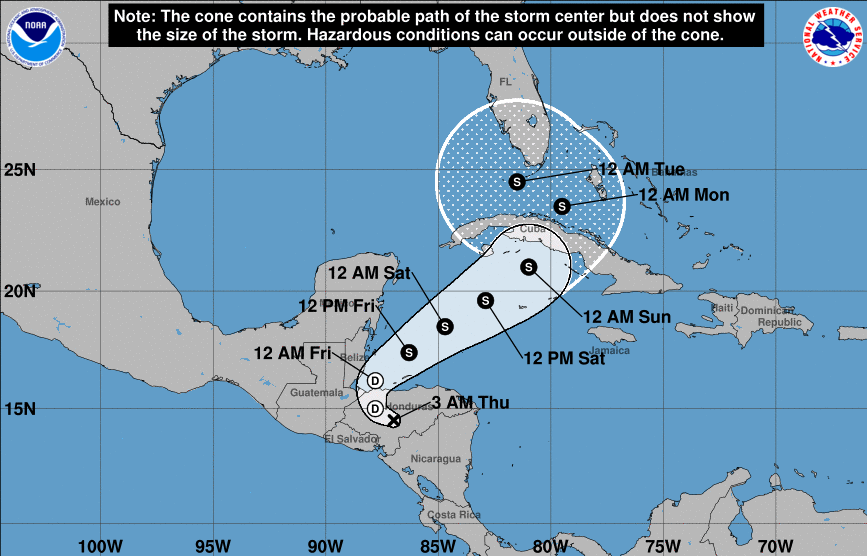 With things staying dry and warm here in East Tennessee, how warm with temperatures get? A look at guidance early next week shows high's as high as 76 here in the valley. The typical average for early November hangs in the mid 60's so we will be well above that this weekend and early next week. Some counties could see as high as 78 by next Tuesday before cloud cover and rain chances finally work back in mid-week.  For now, enjoy another pleasant day. Satellite is picking up on cloud cover already hanging across West Tennessee, but sunshine returns for Friday and through the weekend. More details can be found on our daily video below. Well the results are in and the consensus is...WARM. we will continue to see an up-tick in temperatures over the next several days with temperatures by Sunday 10+ degrees above average. A high pressure system residing over the region will allow the continuation of sunny skies and warming temperatures. 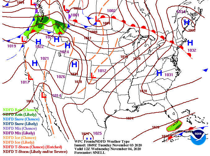 With little to discuss ahead, the main topic is the heat. High's today will settle around average in the low to mid 60's but things continue to trend upwards through the week. High's by Sunday find the mid 70's with these kind of values continuing into next week. Overall, things will stay dry as well as a few high clouds could find East Tennessee tomorrow afternoon, otherwise things stay sunny and warm.  With sunny skies and temperatures warming, enjoy some outdoor time when you can find it. We typically see wide swings in temperatures this time of the year with pattern changes, but we look fortunate to stay on the warm side through early next week. Enjoy it and take advantage! Pre-recorded for 5pm show
Hurricane Eta made landfall late last night in Nicaragua as a category 4 hurricane. This system barreled into the country with 150 mph winds and is expected to bring upwards of 2 to 3 feet of total rainfall now through Friday. As Eta, or what will remain of it by Saturday, works back into the ocean, its next destination is the Caribbean. Luckily, with cooling ocean waters this tropical machine will likely not strengthen much over the course of the weekend and early next week. Hurricane season officially ends November 30th and we couldn't be more glad of that. Not to say hurricanes aren't possible after this date (very much are) but this has been the most active season in history. 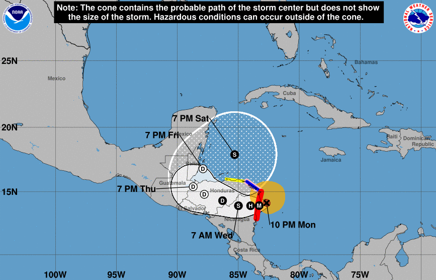 Turning our attention back to home, there is little to discuss over the next several days. High pressure will contribute to warming temperatures in the days ahead, as well as keep things mostly sunny. This would be a great time to get out and about for hiking, camping, hunting etc. Temperatures will be at to above average through the reminder of the week with dry conditions sticking around.  A look at high temperatures tomorrow show's average across the region. A few clouds will linger in for Thursday keeping things again near average before we warm to the 70's Friday and the weekend. This warming trend, as previously mentioned, looks to continue through next week as well.  Enjoy the dry air and warming temperatures. Conditions are vastly different than the 3-4" we picked up from Zeta last week. If Secret City Weather can help you or your business is anyway, send us an email SecretCityWx@aol.com or visit our "Services" tab above. Pre-recorded for 5pm show
We are seeing the coldest temperatures of the season with much of the area near freezing or below to begin the work week. Conditions will improve slightly this afternoon with high's topping out in the low 50's under sunny skies. Look to continue warming through the week.  The latest surface map shows a high pressure system off to the west providing lots dry air across the southeast. This will continue eastward in the days ahead, changing the flow to out of the south. With winds shifting more southerly, this will allow for warming temperatures Tuesday and through the remainder of the week. High's will swing back nearly 10 degrees tomorrow as high's will find the lower 60's by the afternoon.  The CPC suggests the cold period we see today and early this week won't last long. Parts of East Tennessee sit in the 90th percentile for above average temperatures next week (Nov. 7-11). The average temperature in Knoxville for November 1st is 66 degrees and we are forecasting to see high's around 70 by Thursday and Friday. Anticipate temperatures in the 70's much of next week with near average precipitation. 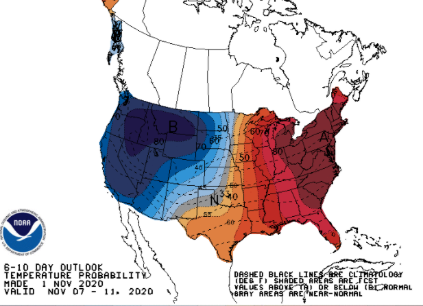 There isn't too much to worry about this week outside of another chilly start tomorrow morning. Temperatures will continue to improve through the week with plenty of sunshine now through Friday. Enjoy it and have a good start to the new work week. Pre-recorded for 5pm show
|