|
Pre-recorded for 5pm weather broadcast
0 Comments
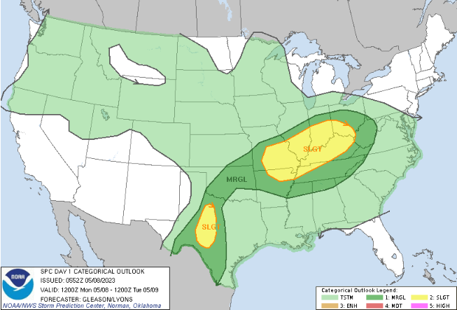
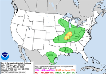
The latest 24-hour temperature map depicts near neutral to slightly warmer temperatures across the northeast and into KY. This is important, as it depicts a building warm front and area of focus for strong to severe storms this afternoon and evening. In summary of the day, mostly cloudy skies are expected this morning (though an isolated shower is possible), with increasing shower/storm chances into this afternoon. 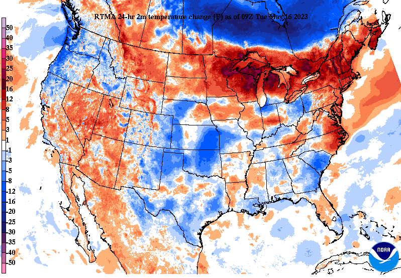 The Storm Prediction Center has upgraded a section of the area to an enhanced (3/5) for locations generally bordering Kentucky. This is along and near the warm boundary mentioned, giving way to all severe weather hazards. The primary threat will be damaging wind gusts, but large hail, and a few tornadoes are also possible. Be weather aware this afternoon/evening and have a way to receive alerts. The timing for severe storm potential will be between 2-9 pm today. 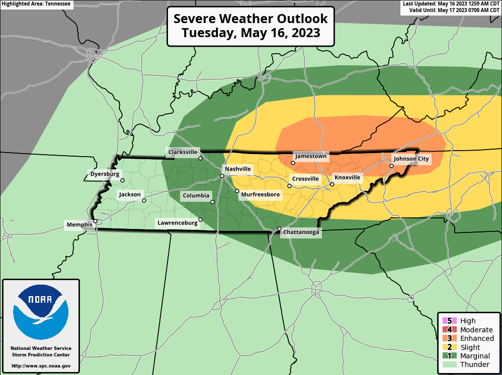 In addition to the severe threat, there is also a hydro threat. Looking from WPC, a slight risk encompasses the area. With pockets of heavy rains the past few days and a series of scattered storms expected today, flash flooding will be possible. This is particularly so for any location that sees repeated activity. These storms will be heavy rainmakers, so take action now if in flood prone/low lying locations. 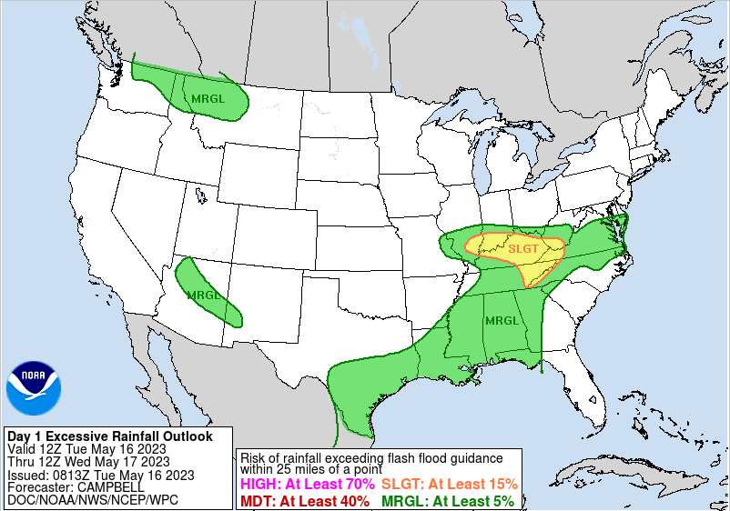 The biggest concern will come this afternoon and evening with storms and flash flooding. Have multiple ways to receive warnings and have an action plan established now. Generally drier conditions follow Wed-Fri, with very low end shower chances during this stretch. A late week/weekend cold front then brings the return of showers or storms Saturday into early Sunday. Check out our video forecast below for more. Pre-recorded for 5pm weather broadcast
Pre-recorded for 5pm weather broadcast
Pre-recorded for 5pm weather broadcast
Pre-recorded for 5pm weather broadcast
A cooler start thanks to clear skies and calm winds last night, but not to worry, we warm up nicely this afternoon. Highs will find the low to mid 80s, with even warmer air this weekend. Overall, a gorgeous day is planned, with sunny skies, low humidity, and light winds. Moving forward though, changes are in the forecast.  With very warm air moving in over the coming days and increasing moisture off the Gulf of Mexico, afternoon pop up showers and storms are likely. Where these form will vary, but timing will mainly be during the afternoon and evening hours Friday through Sunday. Though I can't entirely rule out an isolated shower or storm tomorrow afternoon, any potential will be across the Plateau. Better chances will come thereafter, with a cold front bringing another bout of showers/storms Sunday into Monday. As touched on above and can be depicted below, it's going to get very warm very quickly. Looking at one example of guidance below, highs will sore into the upper 80s by Sunday, with some likely around the 90 mark. Thankfully, the passing cold front will bring temperatures down to our usual average Monday and Tuesday of next week. 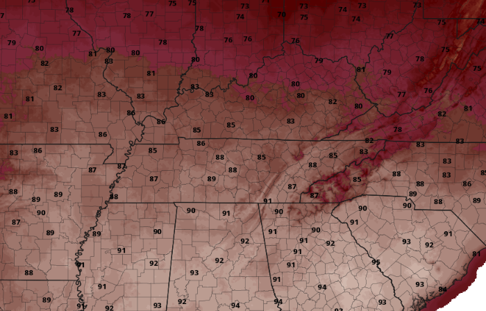 Enjoy the beautiful day we have ahead of us today. Don't forget to also check out our video forecast below, while also hitting that follow button on Twitter and Facebook for additional daily updates. Have a good one! Pre-recorded for 5pm weather broadcast
Pre-recorded for 5pm weather broadcast
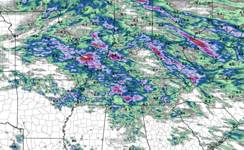
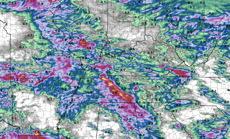
A depressing morning across the Volunteer State as many webcams depict cloud cover and patchy fog. I wish I had better news in saying a bright, sunny, and warm day was ahead, but that is not so. Instead, showers and storms are on the way from Central Kentucky (8:45 am radar scan), with more on the way later in the day. This afternoon will be the "best" time for any out and about errands, though scattered showers or storms will be possible. Into tonight, activity returns as a weak cold front approaches from the west. 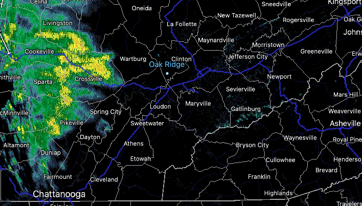 Looking at the threats for the day, both a severe and flash flooding one are present. Showers (as seen above) will fill in for a portion of the area this morning, before moving out early this afternoon. This will give way to a mix of sunshine and clouds, with scattered storms still possible this afternoon. Depending on the evolution of our next cluster of storms and how much energy we gain from clearer skies/heating this afternoon, we could see some strong storms tonight into Tuesday morning. The primary threat will be winds, but some hail and an isolated tornado can't be ruled out. Flash flooding will also be possible (continued below).
What is most in question for me is where the better thunderstorms line up. Previous guidance suggested this swath be across East Tennessee, but more recent data (only 2 examples below) depict this further west (Middle TN). Assuming this trend holds, good news for us. The unfortunate news is that models really struggle with the evolution and depiction of these systems, so as good as these look (for East Tennessee), they likely will not pan out this way. That said, we fair better than locations west and it will be something to closely monitor tonight. With heavy rains yesterday and scattered activity this morning and afternoon, any heavy or repeated thunderstorms over a spot could pose isolated flash flooding concerns tonight. Have a way to receive warnings if issued!
Showers or storms vacate the area by Tuesday afternoon/early evening, allowed by clearing skies into Wednesday. Any big outdoor plans this week? Wednesday is by far the best day to knock them out! It will be sunny, warm (around 80), and pleasant. Shower and storm chances then return in very low chances Thursday, with better chances Friday into the weekend during the afternoon and evening hours each day. Check out our video forecast below for more information. Pre-recorded for 5pm weather broadcast
Good Thursday morning! I hope you are bundled up, as it's a chilly one across the Volunteer State. Temperature readings vary from the mid 30s to around 40 degrees. Thankfully, this will be our last sub-40 degree start for some time, maybe even until the Fall. Nonetheless, we are between 5 and 10 degrees cooler than Wednesday morning (as shown below). Moving through the day, cloud cover will gradually increase, with temperatures also on the rise. Highs should top out in the upper 60s to low 70s, making it feel much more comfortable than many days earlier in the week.  Our next disturbance takes aim tomorrow into the weekend, posing a lower end flash flood threat. This slow moving system will drag a warm front east, sagging just south of the area. Because of this, moisture will pool along and ahead of the feature bringing showers and storms at times the second half of the day Friday into Saturday. With the boundary in place and thunderstorms on the table, instances of flash flooding can't be ruled out. The risk is fairly low, but any heavy and slow moving thunderstorms or areas of repeated activity will be the most susceptible to flooding. As such, have a way to receive watches and or warnings if they were to be issued. Friday night into Saturday will be the best timeframe for any heavy rainfall, with total amounts between 0.5-1.5" Friday through Saturday. Locally higher amounts will be possible. Lingering showers will then follow Sunday, before another disturbance brings another shower threat early next week.  The good news during this time will be the temperatures. After a seasonably cool start the first half of the week, warmer air is en route. Highs will warm to the 80s by Sunday afternoon, continuing into early next week. This will be 5-7 degrees above average by Monday, as our usual high is around 76 to 77. 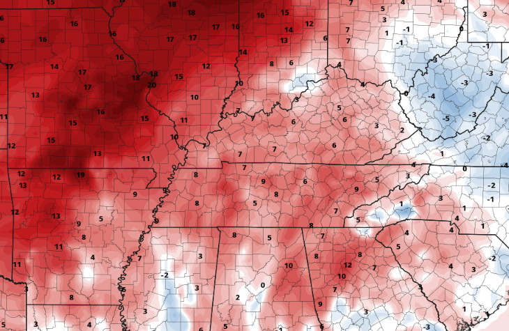 That will conclude it for today, but remain weather aware as we work tomorrow evening through Saturday. Showers or storms could pose a threat for heavy rains which could lead to isolated instances of flash flooding. Have a good one, enjoy the warmth, and stay dry as showers and storms find the area. Pre-recorded for 5pm weather broadcast
|