|
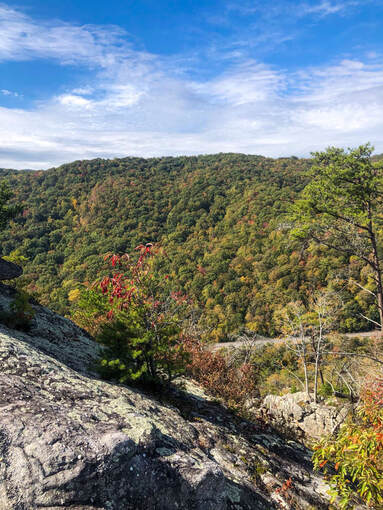
Fall is officially in full swing with lots of colors being shown in the Caryville area this past weekend. It was a beautiful one for a hike, camping, or other outdoor activities. That trend looks to continue much of this week with dry conditions hanging around and temperatures shifting to above normal.
With a bit of cloud cover hanging around overnight and into this morning, it would lead you to think showers are quickly on the way. Luckily, the system to our north and west will stay to the north and move eastward through today. For the most part, sunshine will stay overhead but a few scattered clouds will roll through from time to time (likely again this evening). 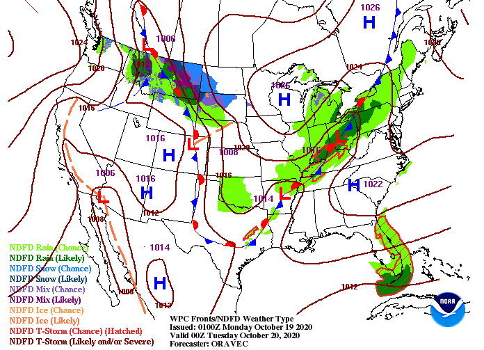 Pressing forward, any showers activity will be to the north and west. By mid-week, the entire region should return to dry air, sunny skies, and warm temperatures. In fact, we are looking to have high's nearly 10 degrees above average for Wednesday and Thursday. Rounding out the work week on Friday, cloudy skies and isolated to scattered shower chances return. 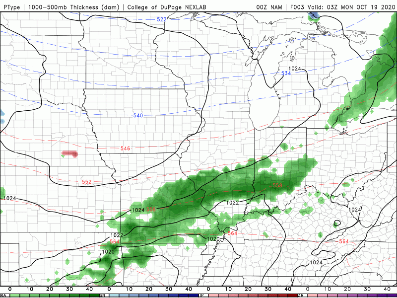 For now, try to get out and enjoy the Fall colors. The vast majority of our area will stay dry through 3/4 of the work week before a limited chance for showers returns to the mix. Have a great Monday and let us know if we can do anything for you or your business! Visit our "Services" tab for more information. Pre-recorded for 5pm show
0 Comments
The cold front has arrived and cooler air is beginning to funnel in. Along with this, we are seeing post-frontal shower activity across the region. This will begin to work out by the mid-morning hours, allowing for clearing the remainder of the day. 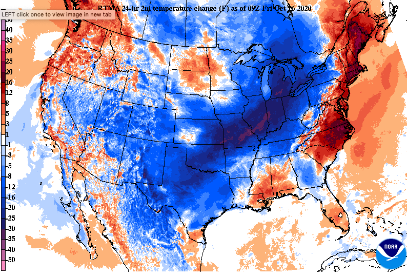 As we work into tonight, the biggest concern will be the first frost of the new season. Areas in the northern half of East TN, the Plateau, and Smokies are all at risk. Some areas, specifically Washington County and the higher elevations of the Smokies, could see freezing conditions as temps drop to at/below 32 degrees. Be sure to cover any plants that you have of value tonight. We'll see warmer temperatures back in the forecast through the weekend and into next week. 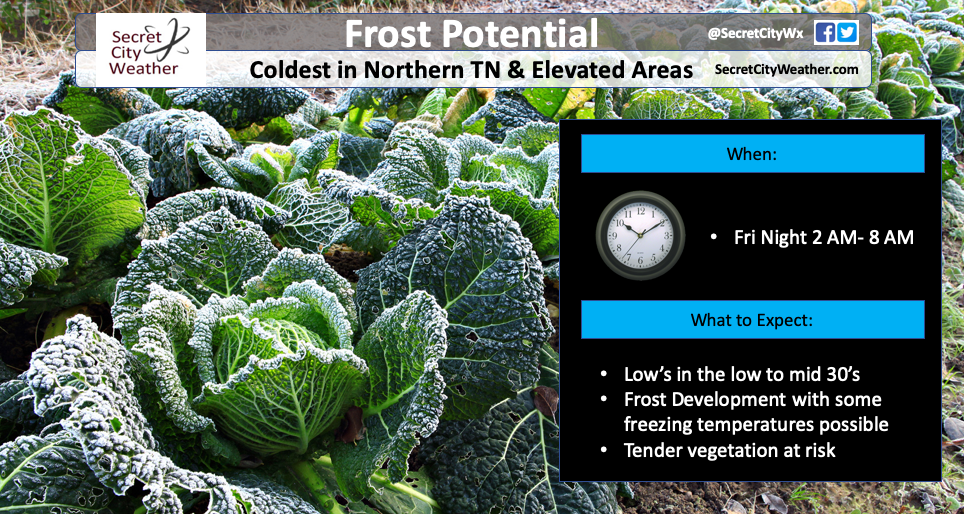 Overall, things stay calm the next several days. A high pressure system will settle overhead, allowing for lots of dry air, sunshine, and warming temperatures. We have another shot of moisture by mid-week next week, but things stay dry until then (once today's morning moisture dissipates out).  Temperatures will be chilly this afternoon and cold for those getting up early tomorrow. Be sure to cover those plants, especially for those who live in the areas mentioned above. High's will gradually return to near average by Sunday with a continued warming trend into early next work week. Have a good weekend and if you do see some frost, let us know through social media or by email: SecretCityWx@aol.com. Current temperatures this morning are in the mid to upper 50's and will warm to high's around 80 degrees. Though it'll be warm for this time of the year, we'll see a quick turn around for Friday. A seasonably cold air mass is working through the Midwest and will find its way into East Tennessee by Friday morning. 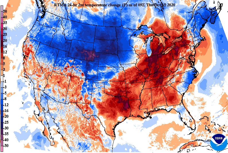 A look at the surface map for tonight shows the front beginning to work in. Along with the front, we will likely see a few isolated showers. By mid-morning tomorrow, things should dry out and cloud cover will slowly work east as well. To the west, a high pressure system will fill in providing sunny skies and temperatures slowly nearing average by Monday. 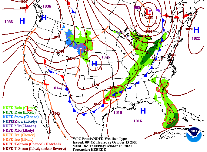 Looking at model guidance, showers will arrive by the midnight hour tonight and work out by the morning, Friday. With little moisture associated with the front this far south, precipitation will be hit or miss across the area. At best, I expect a few hundreds of an inch before this line works out. As we get into the day tomorrow, cloud cover and the chilly temperatures will be the main feature. A concern we are eyeing into Saturday is the potential for frost. Overnight low's Friday will be in the mid to upper 30's. The biggest concern is for those in the foothills of the Smokies and to the north. If you are located in the northern half of East TN, I would take the proper precautions for your plants overnight Friday. I know for many the growing season is coming to an end, but for those still hanging on, warmer temperatures will be back in the forecast. 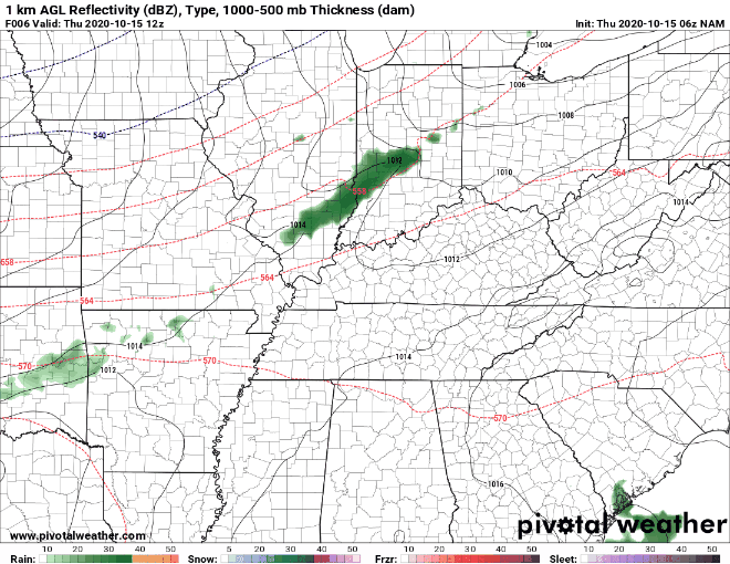 That will wrap it up for today...much cooler air will find its way in to end the work week tomorrow, but above average temps hang around this afternoon. Pre-recorded for 5pm show
Happy Hump Day! Patchy fog is being seen across the valley this morning, so take a little extra time on your way to work and school. As it lifts mid-morning, sunny skies will once again return with high's in the mid to upper 70's. A high pressure system stays overhead providing plenty of dry and warm air today and tomorrow. In fact, high's will be nearly 10 degrees above average Thursday with high's topping out in the low 80's for some. 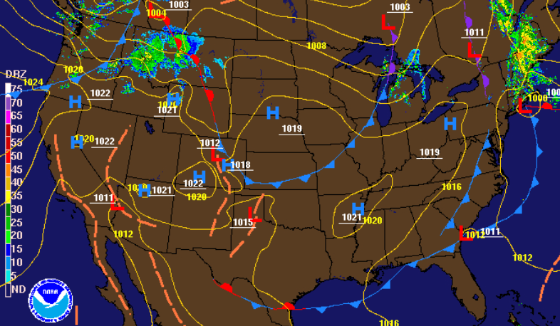 By Thursday night, a sharp cold front will find its way through the Tennessee valley. Check out temperature differences Thursday evening, a 10 to 15 degree difference on either side of the front. Most will be lucky to see high's in the 60's Friday afternoon with the coldest air we've seen so far this season and cloudy skies likely much of the day. Something I would like to highlight is the potential for FROST Saturday morning. Overnight low's Friday will be be in the mid 30's range, where frost could be an issue. As we get closer to time, we will have a better understanding of how quick cloud cover will move out (a very important role in how cool things get). As a precaution, plan for patchy frost in some areas Friday night and we'll have more details as this front draws closer. 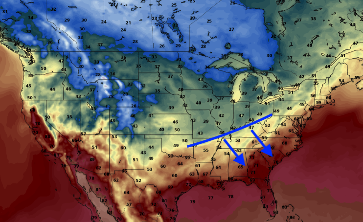 In addition to much cooler air, scattered showers are also likely late Thursday and through the first half of Friday. The majority of showers will hang to the north but don't be surprised to pick up a few hundreds of an inch through the day. Following the front, and associated showers, a high will build in bringing more sunshine for the weekend. Things will begin to work back towards average with high's in the upper 60's to low 70's Sunday and Monday.  Temperatures will continue to warm today and tomorrow but if you are a fan of the cold, good news is on the way. For now, enjoy the sunshine and mild temperatures. Pre-recorded for 5pm show
Good morning and I hope everyone enjoyed their extended weekend. With hurricane Delta gone, we will see cooler temperatures (today only) and sunnier skies returning. There was a record worth noting though...Chattanooga picked up 2.08 inches of rainfall on Friday, beating the previous day-time record of 1.85" in 1905. A look at observed rainfall totals late last week and early into the weekend can be found below as well. 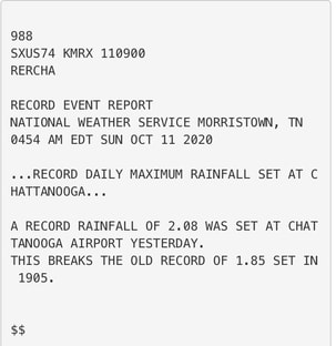 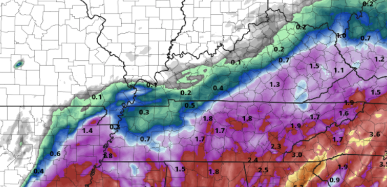 Moving ahead, there isn't too much in the short term forecast. A snapshot of satellite late last night and early this morning shows the isolated showers (mainly to the north) and cloud cover we had. This was all associated with the cooler air we have across the region and will feel this afternoon. High's today will top out right around average of 72 degrees with sunnier skies working in by this afternoon. 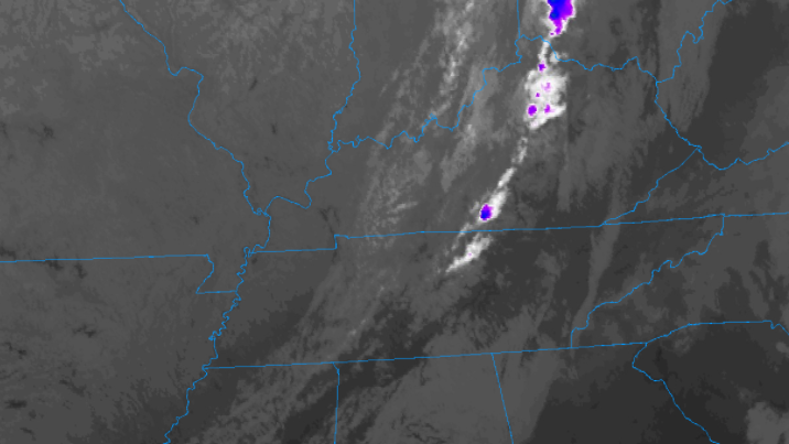 Longer term, things will gradually warm back up with above average temps tomorrow and Thursday. By Friday, a stout cold front will move through, dropping temperatures 10 to 15 degrees below average. Along will much cooler air, a few isolated showers late Thursday and early Friday can't be ruled out. Overall, keep those jackets handy late this week as a cool down is on its way.  Enjoy the conditions today as temperatures will hang around the average. We'll warm in the days ahead before quickly cooling back down Friday and the weekend. Have a good start to the shortened work week! Good afternoon and I hope some of you are enjoying the extended weekend! Things have dried out across the area but cloud cover still remains. A weak front to the west is sliding through, eventually bringing clearer skies by tomorrow. For the rest of this afternoon, gradually clearing, a few sprinkles, and high's in the upper 70's can be expected.  Stansfield Webcam- Oak Ridge The latest surface map shows the front trying to move through. As mentioned, don't be caught off guard if you feel a few sprinkles drop this evening. Little moisture is associated, so any rain that falls will be very light and quick moving. By Tuesday, a high pressure system will dig in from the west drying things out entirely and providing some much needed sunshine. 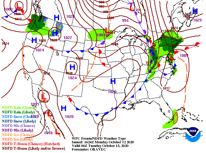 In the days ahead, things return to a quiet state. The high will keep temperatures above average the first half of the week, but sharp changes are in store the later half. A strong cold front from Canada will work south, providing MUCH cooler air across the Mid-Atlantic. This pattern shift is being compared, by some forecasters, to that of an early winter phase. Though conditions won't be winter-like across east Tennessee, we will see below average temps. The biggest highlights Friday and this weekend will be patchy frost and likely the coldest overnight low's we've had since March/April. Along will the blast of colder air, a few light and isolated showers are in the forecast for Thursday and early Friday. 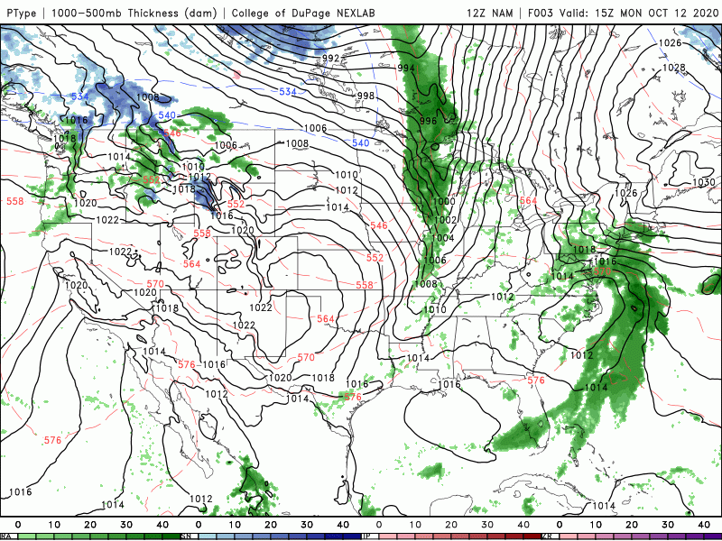 Taking an early look at Friday's afternoon high's, we are seeing upper 50's for most and a few low 60's for counties to the south. The average high for this time of the year varies between 69 (Tri-Cities) and 73 (Chattanooga) with Knoxville around 71. This pattern shift looks to keep below average temperatures in play not only this weekend but also much of next week. 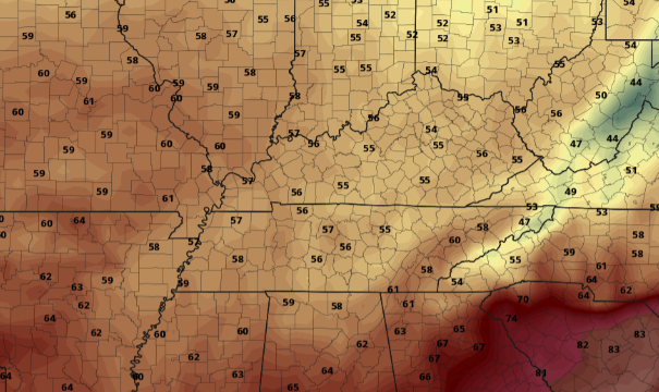 With the holiday today, I went without a video broadcast but will return to the norm tomorrow. I also wanted to touch on some feedback we received over the weekend. Because of the configuration of this site, true timestamps aren't an available option. With that said, I will keep a conscious effort on making sure the posted date is that of the true date. I will sometimes begin a post the evening before and finish it the day of posting (I believe this is why it is one day off). Regardless, thank you for bringing it to our attention and we hope to have that corrected from here on out. I want to wish every one a great rest of Columbus Day and if Secret City Weather can help you out in anyway, send us an email at SecretCityWx@aol.com
Good morning and happy Friday! Cloud cover will continue to work in through the day as Delta moves closer. For now, most should expect to stay dry the first half of the day with isolated to scattered showers working in by this evening and overnight. Looking at the day 2 excessive rainfall outlook, the WPC has placed parts of East Tennessee under a Marginal risk for flash flooding (5%-10%). Given how dry things have been across the area that will help in reducing flash flooding risk, but it is something we will be watching out for as we work into Saturday. 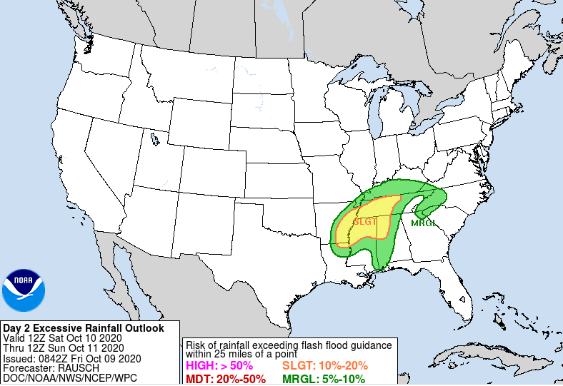 Pockets of heavier rainfall are possible late tonight and through Saturday. A few thunderstorms aren't out of the question either, but severe potential is very low. Remnants of Delta should be begin to work out by Monday morning providing a bit of sunshine back across the area in the afternoon. A system to the west will help force Delta out by early next week while also giving us isolated shower chances and cooler air on the back side. Sunny skies and high's in the low to mid 70's should return by Wednesday of next week.  Overall totals will vary. An initial line of showers will work through ahead of the parent low from Delta, then the brunt of activity the second half of Saturday and early Sunday. As of this morning, totals between the 1-3 inch mark are on tap. As Delta works north today, slight changes in the path will likely impact overall totals. Continue to check in through social media for the latest. 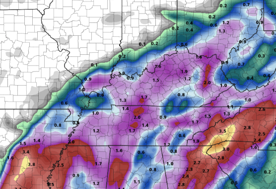 That will wrap it up for today, I hope you've enjoyed our dry streak as Delta will provide a good rain through the region. As I mentioned, tropical systems are hard to pinpoint down, so check in through our social media for updates. The biggest risk this weekend will be flash flooding, but I think due to the dry stent we have been on the risks are low. Delta is beginning to make an appearance on satellite as it works into the Gulf of Mexico. After making brief landfall in Mexico, Delta has returned to the Atlantic and is intensifying as it works into the Gulf.  As of the latest from the National Hurricane Center, Hurricane Delta will continue working northward. Landfall is expected to be made sometime late Friday/early Saturday through the heart of Louisiana. Uncertainty still lies with strength and path but as of this morning, Delta continues to strengthen as it enters the warm Gulf waters. Once landfall is made, Delta will work north and eastward forcing its way into western TN and KY. Again, uncertainty lies with the exact path, so anticipate changes in the days ahead. 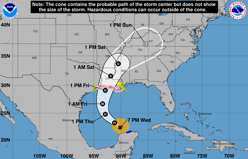 Moving forward, we will phase back towards normal/slightly above normal temperatures. Checking out the the middle of October, temperatures will be similar to what we will experienced Monday and Tuesday. On the flip side, precipitation will more than likely be at to above average. 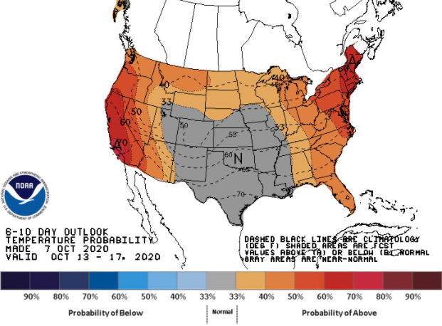 For the short term, things will stay dry today and much of the day Friday. We'll start to see cloud cover migrate in the second half of today, bringing cloudy skies to close out the work week. By the evening hours of tomorrow, a few isolated showers can't be ruled out. Through Saturday, showers and a few storms should be anticipated throughout the day. Again, changes are likely once Delta makes landfall but given the latest, the majority of this system will hang to the west and north (good news for us).  Continue to check back in for updates regarding Delta; changes are inevitable. As for today, stay cool! Above average temperatures will blanket the region with some areas reaching the mid 80's. Cloud cover and the eventual rainfall will cool things back down Friday and the weekend. Have a good Thursday and thank you for relying on Secret City Weather for all your east Tennessee weather needs. The latest satellite imagery of Hurricane Delta shows landfall to soon be made in Mexico. As of last night, this hurricane was a category 4 storm. Expectations are for Delta to weaken as it works through the eastern tip of Mexico and back into Gulf waters. From there, uncertainty lies with strength, landfall timing, and path. 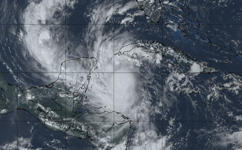 For now, we continue to enjoy the sunshine and above average temperatures. High's today will top out in the upper 70's to low 80's under sunny skies. Similar conditions are in store tomorrow with high's warming to the mid 80's for some spots. By late Friday, Delta will make landfall bringing cloud cover and isolated shower chances to the area. As of the latest, the heart of Delta stays westward, bringing the heaviest rainfall to western and central TN.  Early guidance is suggesting anywhere between the 1 and 2 inch mark here in east Tennessee, but tropical systems are very challenging to forecast for. Given the length of time out and uncertainty in intensity and path, better details will be paved out in the days to come. For now, enjoy the warm and sunny conditions but do anticipate for rainfall through the weekend. Tune in as we progress through the week; more details will be provided as to path, intensity, and duration. Sunny skies and above average temperatures continue for Thursday before tropical moisture and cloud cover find their way into Tennessee by late work week and weekend. After about a week of peace, activity in the Atlantic is back. Tropical Storm Gamma is currently impacting parts of Mexico and will turn northward this afternoon. We will keep a close eye on its path and intensity in the day ahead. As for Tropical Depression 26, it will work north and west, likely developing into a hurricane by Wednesday and arriving into the Gulf. We are several days out but the NHC suggests landfall in the Gulf by late this week.  We saw beautiful conditions this past weekend and expect the same for much of this week. A dominating high pressure will work in, keeping much of the eastern US dry the next several days. Specifically here at home, anticipate lots of sunshine and warming temperatures in the days ahead. We will see high's back in the upper 70's to lower 80's Wednesday and Thursday. 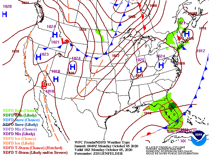 As we transition towards the cooler season, UV indices will slowly get lower. This is due to the tilt of the earth and the associated sun angle. With that said, we will see values in the medium range throughout the week (5-6), so be careful. 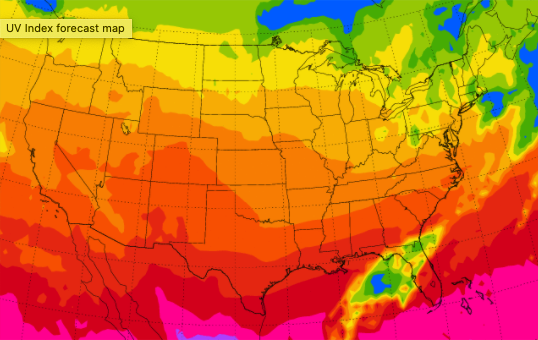 We will kick off the week with more sunshine and high's in the low to mid 70's. Working ahead we will see high's return to the upper 70's/low 80's (the avg. for this time of the year). Enjoy this GREAT weather and check back in for updates regarding the Tropics. We will more than likely see tropical activity impact the US the later half of the week. |