|
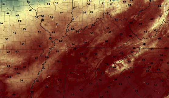
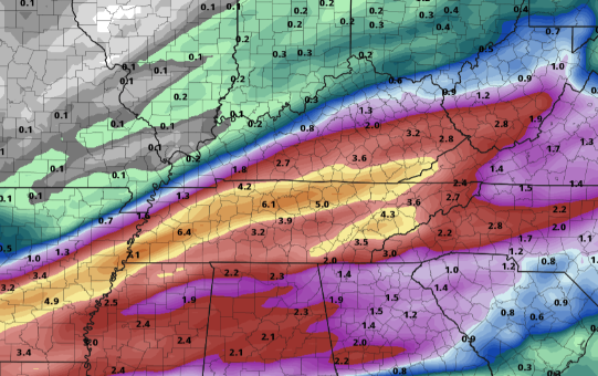
Good Wednesday morning to you! We have a mild start so far with very "warm" temperatures planned for this afternoon. Taking a look below, high's will range from the upper 60's to low 70's with some locations likely to reach the mid 70's. As a cold front works in the later part of the day, we could see breezy conditions in the afternoon. Cloud cover will be on the increase ahead of this weak system as well. As we progress ahead, there's lots to discuss. First, as mentioned above, a system (mainly to the north) will work through tonight bringing light rain to the region before departing early Thursday. We'll dry back out Thursday before another wave brings rain Friday. We discussed this briefly yesterday but this system has shifted further east in some models. Uncertainty still lies within the data but if this does shift a bit further east as the GFS suggests, less rainfall is in the forecast Friday to Saturday. If this turns out to stay its course from earlier guidance, this could be our primer to an extremely wet weekend -> more below...... It seems like every year (specifically in February) we deal with a flooding event. This year seems to be on par with the trend as yet another set-up looks favorable for heavy rainfall and flooding potential. Round 1: Like we suggested above, our system's track Friday will be a big key in rainfall for this weekend. For starters, a more westward favored track could bring us anywhere between 0.5 and 1.25 inches of rain. On the opposite side of the spectrum, scattered showers could bring a few tenths with upwards of a half inch. This doesn't seem like too much of a difference but much more is on the way. Round 2: Following this batch Friday into Saturday, another wave derived from the southwest will work north and east Sunday through early next week. This could be the knock out blow as a warm front lifts north bringing moderate to heavy rainfall Sunday and Monday. This will then be followed by showers ahead of a cold front Monday into parts of Tuesday. This will be highly dependent on the track of the system and where the axes of heavy moisture ends up. We are still many days out and changes are likely. For now, the graphic below gives you a rough idea on how much rainfall we could see over a 4 day period. Flooding is a big concern working into this weekend and early next week, so check in for updates in the days to come. Enjoy another Spring-like day today with temperatures a bit cooler tomorrow. Rain should be out by the morning Thursday with partly cloudy skies to fill in by the early afternoon. Working towards the weekend, tune back in as a flooding scenario is could be on our radar. We'll keep you well updated with the latest. Pre-recorded for 5pm show
0 Comments
Leave a Reply. |
Your trusted source for everything weather in East Tennessee.
Social Media
|


