|
If you have yet to leave the house be sure to pack the umbrella with you this morning. Showers are currently falling across the area with a some pockets on the Plateau and Smokies picking up some snowfall. A look at the surface map below shows a low working through in a northeast fashion. Showers will be likely the first half of the day with cold air to follow into Thursday. 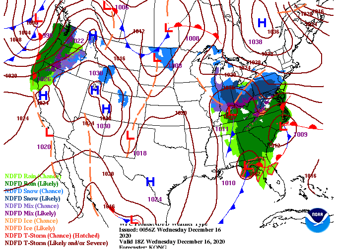 Model guidance continues to suggest some areas (the Plateau, Smokies, and higher elevations of northern TN) will pick up some snowfall this evening/overnight. Accumulations will be very limited with anything significant areas too high in the mountains for any worry (unless you plan to hike/camp/etc.) As we get into Thursday, things will be cold and cloudy. Gradual clearing will take place through the day with sunshine by Friday. Again, this won't last long as another (weaker) system works through Saturday into early Sunday.  Aside from the showers we see today, the biggest risk will be the cold temperatures tomorrow. Overnight low's tonight will drop to around freezing, leaving the chance for patchy black ice on elevated surfaces and bridges/overpasses early tomorrow morning. Unfortunately, things don't look to warm up much with high's tomorrow in the upper 30's. The plateau and Smokies will be lucky to surpass freezing (32) so have the Winter jackets ready! 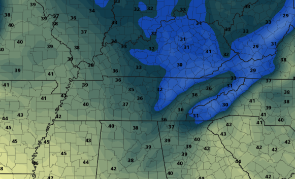 Make sure to grab the umbrella out of the door as we'll see showers through early this afternoon. Things begin tapering off and moving out by this evening with colder air to follow for Thursday. As I am sure you have seen, Secret City Weather has opening sponsorship opportunities for anyone in and around the area. For more information on what options are available visit SecretCityWeather.com/sponsors or email us directly at SecretCityWx@aol.com Pre-recorded for 5pm show
0 Comments
As the cloud cover from overnight slides eastward and out of the area, check out the views on top of Clingmans Dome. Things are a bit chilly here in the valley at 33 but a few thousand feet above us, Clingmans Dome currently sits in the 20's. As we progress into today, take advantage of the sunshine. Temperatures will also likely be the warmest of the work week (near 50) with much cooler air in store Wednesday and Thursday. 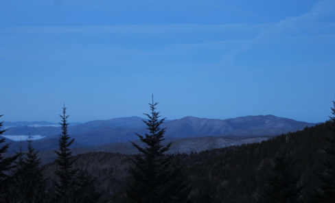 Taking a look at our next weather maker, a system to our south and west will slide in overnight tonight. With low's expected to be in the low to mid 30's, some mixing will be likely to begin the day Wednesday. Unfortunately, accumulations will be very limited (staying to the higher elevations). As the sun rises Wednesday, warming will take place, transitioning any snow/frozen matter back to liquid precipitation. Rain showers are likely the first half of the day before becoming more scattered by the afternoon and evening. A trailing cold front will drop temperatures to the 30's for high's on Thursday, so bundle up! Sunny skies plan to return for Friday before a weak system pushes through for the weekend.  A look at the rain maker overnight tonight and through tomorrow, we aren't expecting a huge washout. Model guidance is hinting at anywhere between a quarter and half an inch. Higher amounts are likely for the higher elevations as upsloping takes place. This will also be the most likely areas of snow accumulation. Overall, this will be another good opportunity to see a few flakes flying as well as keep any potential drought conditions at bay. 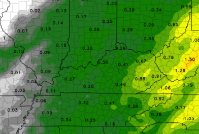 Enjoy the sunshine we see today because it won't last long. Snow, rain, and much cooler air are on the way midweek before warmer temperatures and sunshine finish us out on Friday. We also are accepting sponsors for the second annual Secret City Weather East Tennessee Almanac. More information can be found at: SecretCityWeather.com/Sponsors Pre-recorded for 5pm show
As the tail-end of showers works through this morning, we are seeing the cold air surging in. A transition to snow showers can be seen for parts of the northern Plateau and southern Kentucky with minor accumulation possible. The bulk of any snowfall will accumulate in southeastern Kentucky and the Smokies of East Tennessee. Gradual clearing will take place throughout the day today with sunshine returning into Tuesday. 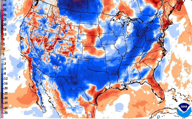 Something we haven't talked about much lately are the UV indices. Reason being? The UV index is low through the late Fall and Winter months due to the angle of the sun. As you can see below, values are in the 2 (light green) to 3 (darker green).  The current loop of showers across the region can be found under the "Radar" tab above. For the most part, this lines up with model guidance this morning. Anticipate things to begin dying out by the mid-morning hours with cloud cover to slowly clear out through the remainder of the day and overnight. A brief area of dry air falls into Tuesday before another round of showers & snow showers arrives Tuesday night and Wednesday. Similar to the event moving through our area now, we'll see snow showers overnight Tuesday then a transition back to rain showers throughout the first half of Wednesday. 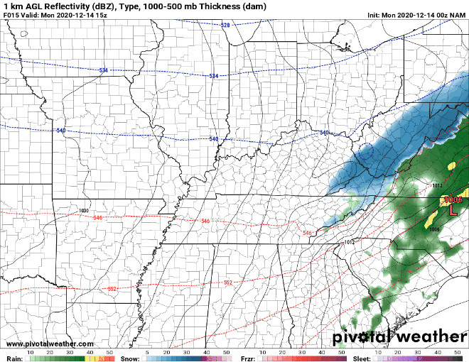 Unfortunately, snow accumulations will be a bust again this week. A few flakes can't be ruled out here in the valley but we'll have to wait some more time before a good snow returns to East Tennessee. For now, try staying warm as temperatures will be in the 40's for much of the work week. We also would like to announce we are accepting sponsors for this years Secret City Weather Almanac. Sponsorship opportunities include Full, Half, and Quarter page slots. Premium options are also available. If you are interested in being a sponsor for this year's release, visit http://www.secretcityweather.com/sponsors.html. Donations are also welcome and can be done so through the "Donate Today" button on our home page. Pre-recorded for 5pm show
Friday is here and so are the warm temperatures! We are starting the day right now nearing 40 degrees but will warm to high's in the mid 60's. Where does this compare with the average? Knoxville averages a high of 51 this time of the year so we will likely turn out 15 or so degrees above that this afternoon. A look at an updated drought map for the state shows abnormally dry conditions have expanded to include all of Western Tennessee and parts of Middle Tennessee. With the minimal rainfall this weekend and into early next week, this is something we need to keep an eye on. For now, normal conditions lie across our neck of the woods. 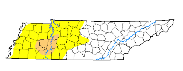 As we progress through the day, a low to the west will draw closer. Because of this, anticipate increased cloud cover for the afternoon and overnight. This will be one of two systems that move through this weekend. The second will come late Sunday and early Monday bringing another round of scattered showers and cooler air for Monday. A chance for flurries can also be contributed to the second system for Monday morning.  The trends have been holding steady the past few days showing this system breaking up as it works east. A line of showers and moderate winds will push through Western TN Friday night and arrive to East Tennessee by the mid-morning to early afternoon hours. As seen below, the loss of forcing and moisture is present as it progresses eastward. With that said, I do expect some light showers for the majority of the area Saturday, but they should be quick moving. Gusty winds at times can't be ruled out either with a fair decent southwest flow. Winds Saturday will be between 10 and 15mph with gusts up to 20/25. Rainfall totals look to be between the 0.1 and 0.2 inch mark. The second system looks a tad more promising, arriving late Sunday and into early Monday. A cold front will hug the back edge of the moisture plume, providing the opportunity for a few flakes (especially for the higher elevations) late overnight Sunday. No accumulations are expected across the valley with minor totals possible for the Plateau and into southern Kentucky. Conditions begin to clear back out Monday afternoon before a third (weak) system is possible midweek. 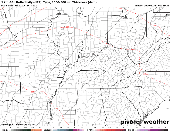 For now, end the work week on a strong note as we'll have both pleasant sky conditions and temperatures this afternoon. A few showers will work through on and off Saturday and late Sunday so be sure to view our "radar" tab for where things are wet. Pre-recorded for 5pm show
Good morning! For those of you still packing up the car this morning, consider taking a little extra time to work and school. Patchy fog can be see across the region (this view from the Stansfield Cam in Oak Ridge). 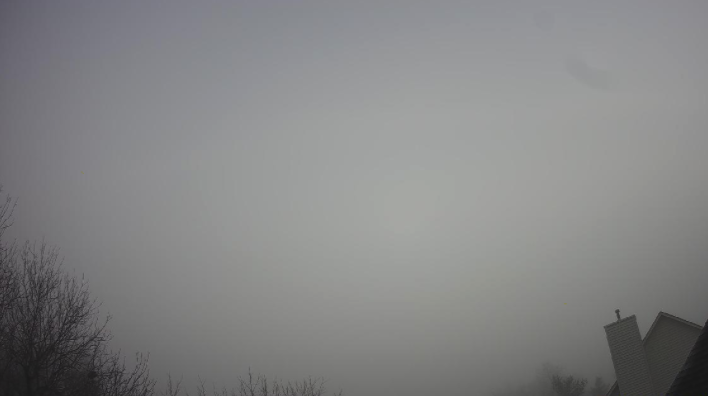 As promised, the United States drought map is shown below. Not only has it been a record-year for hurricanes and tropical activity, but we also have had a record number of wildfires (with many still active running from New Mexico to Washington and extended as far out as Colorado to the west coast). The latest weekly update will be published later today, so we'll have a better idea of the conditions across Tennessee for our Friday discussion. 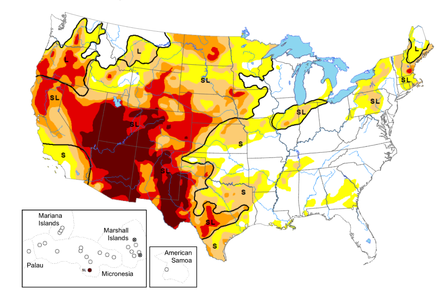 Moving into our next weather-maker, cloud cover will increase the second half of the day tomorrow. A few light showers (ahead of the system) could arrive overnight Friday, otherwise the bulk of activity will fall late-morning to early afternoon Saturday. A trailing cold front will cool things down quickly the later half of Sunday, providing the opportunity for a few flakes across the region. As of now, no accumulation is expected across the Valley. We could see minor accumulations (few tenths) across the Plateau with better opportunities in the highest elevations of the Smokies. For now, our main focus will be the rainfall bringing near half an inch to East Tennessee.  Be sure to take advantage of the conditions we have across East Tennessee. It is not too common we have sunny skies and high's in the low 60's for mid-December. This trend continues one more day (Friday) before showers and a cool down follow. Pre-recorded for 5pm show
As heights continue to rise with high pressure settling in, we'll see a favorable change in temperatures. High's will warm to the mid 50's (near to slightly above average) today and 60's tomorrow and Friday. Sunshine will also stick around making things feel a bit warmer at times this afternoon. 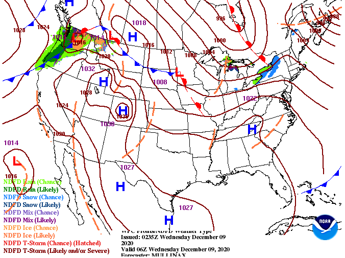 Moving forward, there will be little change in the short-term forecast. Sunshine and the continued warming of afternoon high's continues through Friday. By Friday afternoon, increased cloud cover (associated with a low) will bring the potential for showers for the start of the weekend. Trends in the guidance is still being solved as this particular one (below) has the line thinning out and weakening on its eastward trajectory. Other sources of data suggest a large swath of moisture throughout the day and into Sunday morning. For now, we went more conservative but this could change as we work closer to Saturday. Either way, do anticipate cloudy skies for much of the weekend and the chance for showers Saturday and the first half of Sunday.  We mentioned in a few previous write-ups that this coming Winter will likely be a late one. The latest monthly outlook from the Climate Prediction Center reflects that as well. The month of December (nation-wide) looks to end above average as a monthly mean. Like-wise, precipitation looks to end below average for much of the US. This is not good for the major drought conditions taking place across the western US (will provide that tomorrow). We'll continue to eye conditions here at home as well.
That will do it for today, thank you for viewing! We should have the Almanac sponsorship webpage up sometime next week if you are interested in purchasing a section for your company/business. Pre-recorded for 5pm show
Wow, take a look at the views over Clingmans Dome this morning. With snowfall throughout the day yesterday, it is like a picture perfect winter wonderland across the higher elevations of the Smokies. Here in the valley, we are still dealing with overcast skies with improvement to follow during the day. By this afternoon, anticipate sunny skies and high's in the mid 40's. 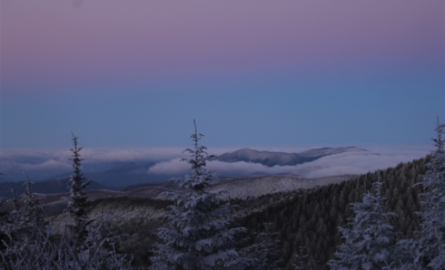 Working ahead, high pressure keeps things dry and warming. High's by Thursday and Friday will be nearing to exceeding the 60 degree mark (well above the average). We will also welcome another rain maker to East Tennessee Saturday will cooler air to follow. Overall, the remainder of the work week stays pretty quiet with sunny skies and warming high's each day. Late Friday night through early Sunday morning will be the target opportunity for rainfall before we dry back out this time next week.  Enjoy warmer temperatures today and in the days ahead. Conditions look to be above normal mid to late week so take advantage! We will also be looking for Sponsors in our 2021 Almanac so if you'd like to post an ad/information about your business we will be getting that information out soon. Pre-recorded for 5pm show
Good Monday morning to you! It is a dreary start with temperatures in the 30's and a layer of clouds overhead. The latest shot from Newfound Gap shows a fresh bed of snow that continues to fall in the Smokies. So far today, Newfound Gap has picked up right around half an inch of snow. Here at home, things look to stay much of the same as they started. High's are expected to top out around 40 degrees with improving conditions by the evening hours. A northwest wind near 10 mph (at times) will make things feel even cooler through the day, so be sure to bundle up. 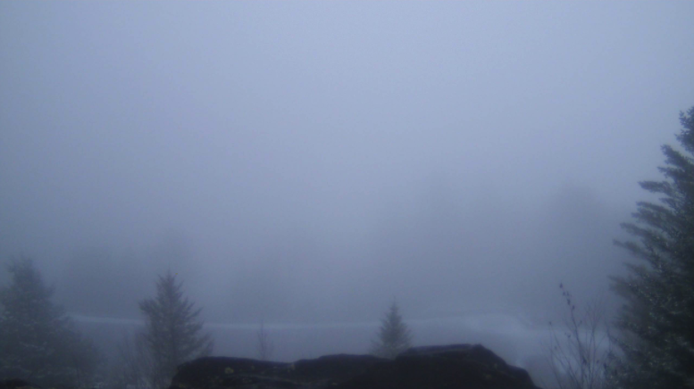 Looking at the current surface map, the low that tracked in some light moisture last night has shifted eastward. Snow flurries can't be ruled out through the day, but no accumulations are expected in the Valley. A bit of a different story is in play for the Smokies (as seen above) with a Winter Weather Advisory is in effect through midnight tonight and a few inches expected on the highest peaks. 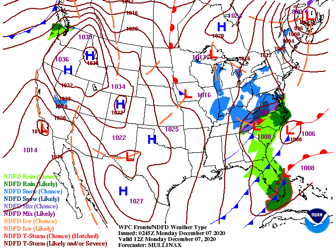 Looking ahead, we begin the clearing out process overnight tonight as high pressure finds its way back across the southeast. This will bring sunshine and warming temperatures Tuesday through Thursday before another opportunity for minimal rainfall finds its way this weekend. Overall, things look to be beautiful Tuesday through much of Friday so take advantage!  That will do it for today. Stay warm as high's struggle to find the 40's much of the day and NW winds will make feel-like temps in the low to mid 30's at times. Check out today's video forecast for more details on what you can expect later in the month. Radar has moderate rainfall beginning to work in across East Tennessee, so use caution on your way to work and school. These showers will continue into the late morning hours before becoming more scattered to isolated. This all associated with a low just to our south that will work eastward rather quickly by this evening and overnight. In behind, high pressure will fill its place providing sunnier skies through Saturday and Sunday. 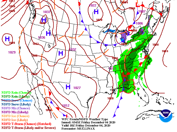 Model guidance paints the picture...rainfall is already working into the region this morning and will likely continue on and off through this afternoon. The positive with this will be the relative quickness of the system. Things will begin clearing out overnight tonight as sunnier skies prevail into the weekend. 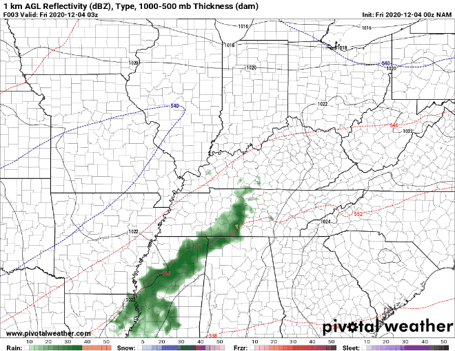 Counter to what I mentioned yesterday, conditions have worsened in parts of Perry, Decatur, and Henderson counties. Hopefully with the addition of today's rainfall, these moderately dry conditions will clear back to the closer norm. It will definitely be something we'll pay close attention to in the weeks ahead. Here at home, things stay right at normal and with general rainfall amounts between half an inch and an inch through the day today. Things turn dry again for much of next week so we'll see how things play out. I will mention, climatologically, December is one of our wettest months during the year. The pattern ahead keeps temps around average and sunnier skies above (Tuesday thru the work week). 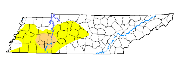 For those heading to the Vols game tomorrow or will be out and about, stay warm. Things will be chilly through the weekend with high's in the 40's (below average for this time of the year). On the flip side, things stay dry with improving sky cover so enjoy that before a few isolated showers become possible on Monday. Have a great weekend and don't forget to share your pictures by tagging us on social media or emailing them to SecretCityWx@aol.com Another chilly morning is here with current temperatures in the mid to upper 20's (some improvement since this time yesterday). We will also see a jump in high's with things rounding out in the low to mid 50's this afternoon. An increase in cloud cover is expected as showers find their way back late tonight and into Friday. A look at the latest drought plot for Tennessee has much of Western Tennessee under abnormally dry conditions. The latest data is expected to come out later today, so we'll include that in the forecast tomorrow for comparison. I would expect better results, and at the very least, the same outlook given the rain and snowfall we picked up this week. 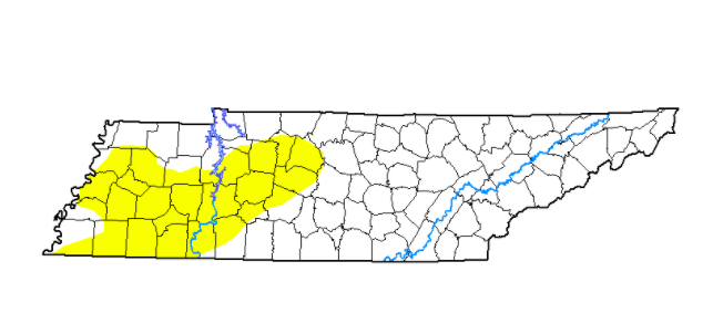 The good news across the state is the retreating cold temperatures. A more southern flow combined with high pressure (now to our east) will allow for high's closer to average this afternoon. Today and tomorrow temperatures will trend near average before another shot of cool air drops things back down into the mid/ upper 40's through the weekend.  This next system won't be a gigantic soaker across the state but most will likely see rainfall through the day Friday. Guidance suggests anywhere from the 3/4" mark up to 1.25". Guidance continues to push for higher amounts as the low trends more northerly, so we will be sure to watch carefully. Overall though, not expecting any impactful conditions for our neck of the woods. If anything, this should help any drought-like conditions we have (again more details into Friday). 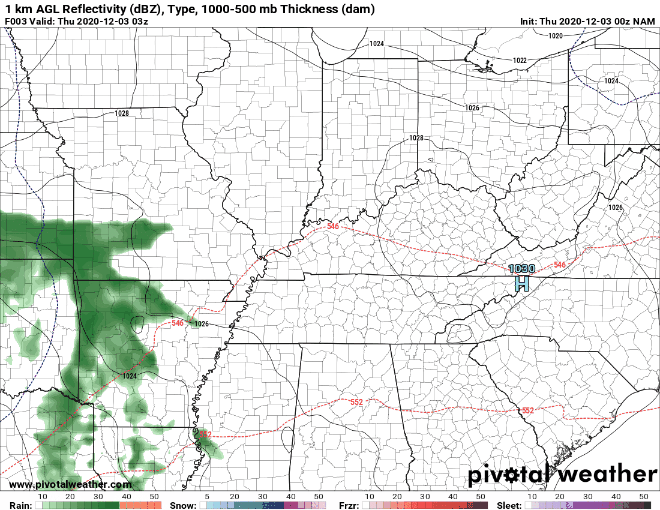 Enjoy some of those warmer temperatures today as we push back closer to average. We'll see some rain end out the work week tomorrow before drying back out for the later part of the weekend. |