|
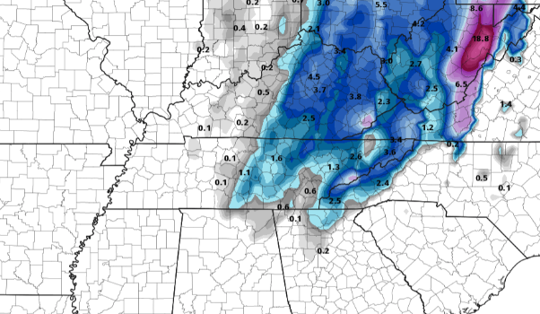
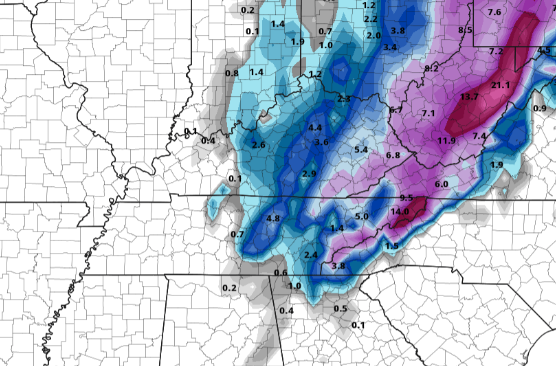
Good morning! This view comes courtesy of TDOT on Lovell Road in Knoxville. Clear skies will begin the day and continue throughout as high pressure sits overhead. With the system to our north yesterday, a cold front did pass through the area. This will keep temperatures at bay today (lower 50's) before return flow warms things up for Hump Day (tomorrow). Short-term data is beginning to feed in along with a narrowing consensus as it relates to the wintry precipitation expected Christmas Eve. First, the dynamics with this next storm system are impressive. Rain will begin the event Wednesday night bringing moderate to heavy rainfall at times and gusty winds. Areas that are very flood prone could see minor flooding, so be careful. As we work into Thursday, a cold front will power its way through bringing a transition to snowfall in the afternoon and evening. There are still some questions on how quick this cold front will move through. A quicker arrival will allow for more snowfall, while a slower arrival leaves less potential. As data (especially short term higher resolution data) comes in, we will have a better picture/grasp on the arrival time of the cold air mass. For now, here is a look at two model extremes showing higher snow totals with a quicker arrival time (right) versus a slower arrival time (left) with lesser totals. Either way, data is narrowing in on a solution. With what's in front of us right now, I do expect some accumulation across the region. The central valley and north can expect (as of now) half an inch to an inch. Further east, the foothills and into the Smokies will near the 1-3" mark with much higher totals expected on the peaks and higher elevations. Some changes are likely in store ahead, so check back in for updates along the way. A beautiful day is in the making today with temperatures remaining above average. A big change is in store the later half of the week so be sure to tune in for updates here and on social media. We will continue to provide the latest as it relates to the timing of the cold front as this will be our biggest judge on how much snowfall we see across East Tennessee. For now, pretty minor accumulations are expected but things are likely to change some over the next couple of days. Pre-recorded for 5pm show
0 Comments
Leave a Reply. |
Your trusted source for everything weather in East Tennessee.
Social Media
|


