|
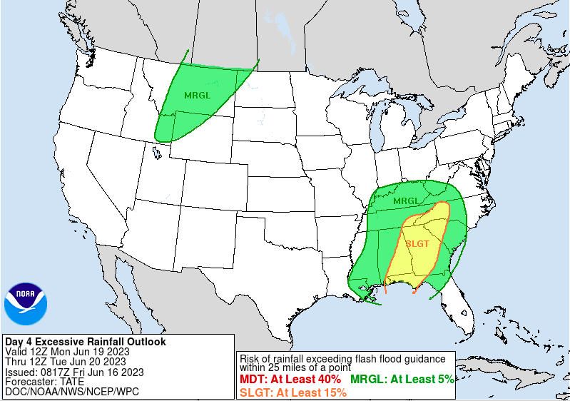
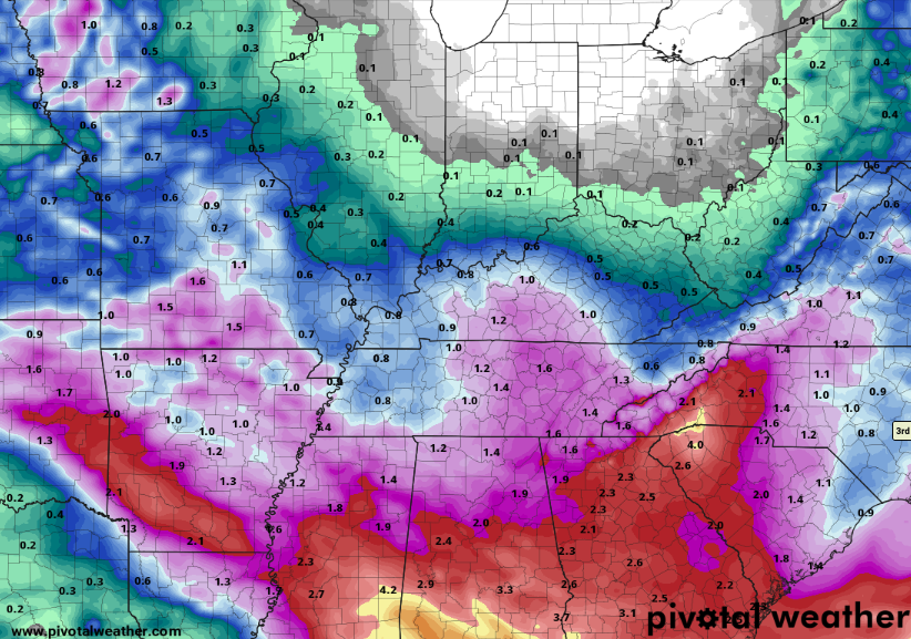
We will close out the last post for the week highlighting Sunday into early next week. We have been monitoring the evolution of a disturbance that will bring rounds of rainfall Monday-Wednesday, but some better trends have shown. That said, let's start with what WPC suggests Monday into Tuesday. As you can see below, a slight (Day 4) risk of flash flooding remains present across the SE, while the remainder of the area is under a marginal. This seems sufficient for a worst case scenario, as the south and southeast will more than likely see the most rainfall overall. Amounts as of this morning look to vary between 1.5-2.5" - a trend toward lesser amounts since yesterday and there's a reason (follow below). That said, large scale models do a poor job at picking up on smaller scale features/details so instances of thunderstorms (slow moving or strong, along with subtle boundaries and more) won't be properly ingested here. As such, amounts will vary with localized higher amounts likely. Now, on to a positive trend. What we have been watching is an upper level disturbance working in from the Central Plains. This feature, boxed in below, develops in the Mid Mississippi Valley and gradually works its way through the Tennessee Valley and then south. Previous data suggested this to stall out along the Appalachians or slowly shift towards the Mid Atlantic into midweek. Recent trends veer this towards the Gulf, which would result in a lesser influence, and thus, lesser rainfall. Assuming this trend holds that would lessen our odds of heavy and/or repeated rainfall and the overall flash flooding threat. We will keep an eye on things through the weekend, but this is a positive sign. So what about this holiday weekend? Well, it is going to be a mixed bag! Most will stay dry today with sunny to partly sunny skies and highs in the mid 80s. High pressure builds in for the day Saturday (dry and mild), followed by a warm front and approach of the mentioned low pressure system. This will raise highs pretty significantly Sunday, where most top out in the upper 80s to low 90s. Showers and a few storms will also be possible late afternoon and into the night, with widespread activity planned on Monday. As this system weakens and tracks south of the area towards midweek, shower chances become widely scattered.
For more information as it's released along with further weather updates across East Tennessee, follow Secret City Weather on Twitter and Facebook (@SecretCityWx)
0 Comments
Leave a Reply. |
Your trusted source for everything weather in East Tennessee.
Social Media
|


