|
Pre-recorded for 5pm weather broadcast
0 Comments
Pre-recorded for 5pm weather broadcast
Mostly cloudy skies start the day off and will continue to hamper the area through tonight. A low pressure system, currently across the Midwest, is poised to pass through the Ohio Valley this evening. This will bring precipitation chances into tonight. Rain shower chances increase in potential through the afternoon, with the highest chance overnight. As a cold front swings across the area and temperatures crash down, a change over to mixed precipitation (rain/snow) will be possible. Locations higher in elevations will have the best chance to see the mix or changeover, while those in the valley will be lucky to see a few wet flakes late tonight into Wednesday morning. Outside of the Valley and Plateau, accumulating snow is increasingly likely for the Smokies. Elevations above 2,000 feet face the best chance of receiving a dusting to half inch (on grassy and elevated surfaces), while the highest peaks of the Smokies could see several inches up to half a foot. Check out this graphic below, which depicts the probability of exceeding 2" tonight. (Greater than a 20% chance- keep in mind this is low in resolution, so probabilities are much higher for the peaks of the Smokies) 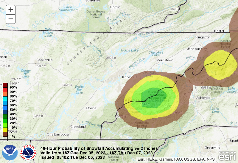 Here is a play-by-play of a potential outcome. Though this should be taken with a grain of salt, it does represent the overall message. Showers will sweep through tonight, before cooler temperatures force a rain/snow changeover. The highest elevations along North Carolina will see mostly all snow late tonight into tomorrow, with activity tapering off into Wednesday afternoon. Thereafter, high pressure fills in Thursday, bringing warmer temperatures and plenty of sunshine. Plenty of sunshine and even warmer air finds us Friday. 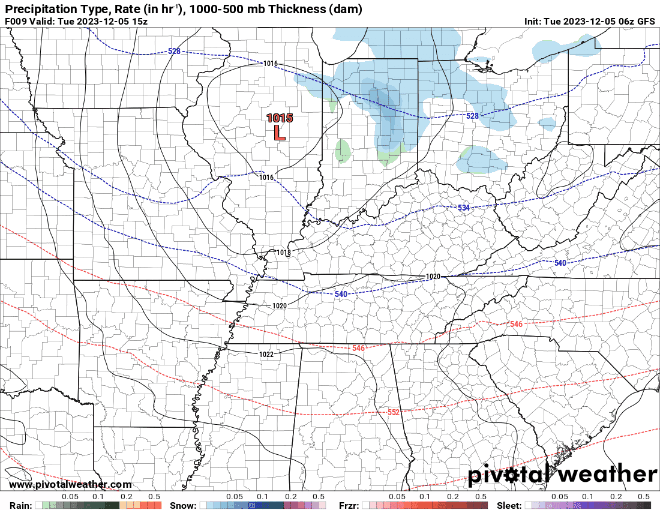 Looking towards this weekend, a strong area of low pressure will pass by north. This will bring the chance for thunderstorms, some of which could be strong, along with a soaking rainfall. Be sure to check back in with this weekend's system, as it could pack a punch across portions of the Deep South. Have a good one, stay warm through tomorrow, and enjoy the sunshine and mild temperatures Thursday and Friday. Pre-recorded for 5pm weather broadcast
I hope your Monday is off to a great start! For those who have yet to head out of the door, don't forget to pack an umbrella and a light coat. Shower chances will be sparse today, and primarily for locations along and north of I-75, but it's better to be save than sorry. Temperatures are also cooler this morning than this time yesterday, with most in the upper 30s to low 40s. The good news is showers should be out by the early afternoon, leaving partly cloudy skies later this evening and much of the overnight. Highs today to top out around average, in the mid 50s.  Checking out one piece of model guidance, any scattered showers will exit northeast of the area this afternoon. This will be followed by yet another quick moving disturbance, which brings precipitation chances Tuesday night into Wednesday. In large part, activity will be in the form of rain. That said, the higher terrain will see temperatures drop much quicker, where a transition to snow is likely. This will occur in the far east, bordering North Carolina, with elevations above 2,000 feet fairing the highest odds.  In fact, looking at the probability of exceeding 2 inches of snow, the Smokies fair a greater than 10% chance. Keep in mind the resolution is not the greatest to best capture true amounts, but the highest peaks of the Smokies could pick up a few inches before all is said and done Wednesday morning. Elsewhere, snow will not be a concern and mainly a chilly rain is expected Tuesday night into Wednesday morning. High pressure then returns Thursday, allowing for plenty of sunshine and moderating temperatures through the end of the work week. Another weather system is forecast this weekend. 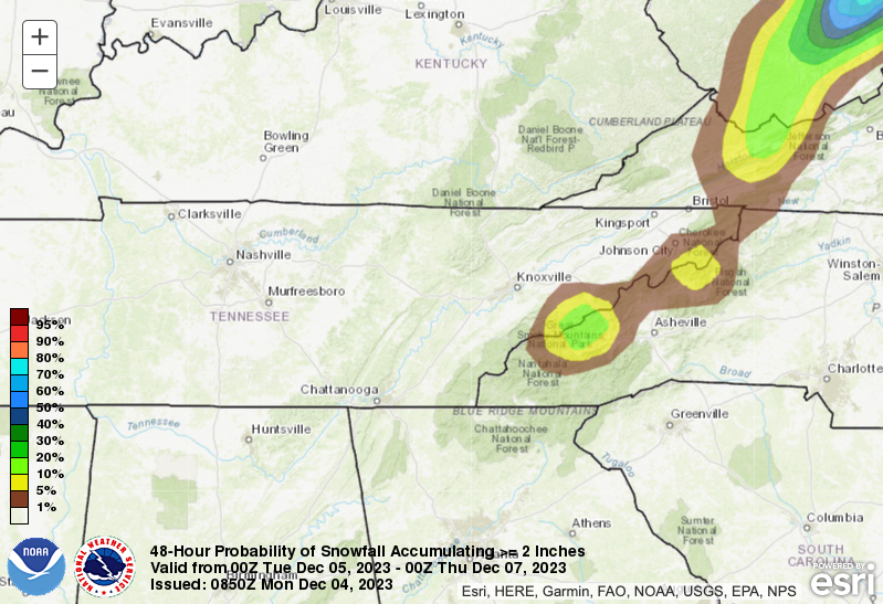 Unsettled weather will be the trend through midweek, with chilly temperatures at times as well. Highs today will be near average, but fall to the low and mid 40s for highs by Wednesday. Keep the warm gear and rain gear close by through Wednesday, before dry weather returns Thursday and Friday. Pre-recorded for 5pm weather broadcast
|