|
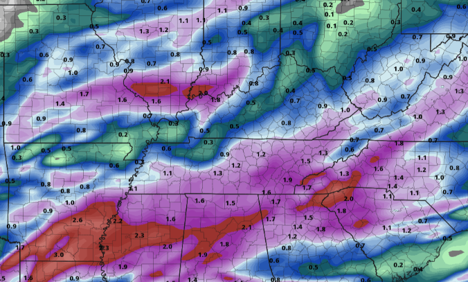
It's a bone chilling morning (for this time of the year) as current temperatures across the valley sit in the upper 20s and low 30s. To put in perspective how abnormal this air mass is, the average low for mid to late April is near 50 degrees. The record low for the 21st (in Knoxville) is 27 degrees and is 31 degrees for today (the 22nd). We'll see what was officially recorded later today, but I bet we come close to the record. For tonight, we'll be a bit warmer, so not expecting a record beating night. With that said, frost conditions are likely, especially for sheltered locations. Looking ahead, another system looks to bring heavy rain across the Volunteer state. High pressure will be edged out by a strong low to our south, bringing moderate to heavy rain at times Saturday. A warm front will lift northward bringing warm temperatures (along with trailing high pressure) to follow late in the weekend and early next week. Highs are expected to average above average; quite the difference from what we feel now. Looking at rainfall totals, some locations could see upwards of 2 inches from Friday night through Saturday evening. Flash flooding isn't a huge concern, given how dry we have been the past several days, but localized flooding can't be ruled out entirely. Expect rainfall to work out by Saturday evening with clearing in for Sunday and sunshine for early next week. Another chilly night tonight with lows in the mid to upper 30s. I expect frost advisories to go out with the afternoon package today from the NWS, so be on the look out for that. Protect those plants one more night, and we should be in the clear. Temperatures next week will average on the warm side with highs some days in the low to mid 80s. Pre-recorded for 5pm show
0 Comments
Leave a Reply. |
Your trusted source for everything weather in East Tennessee.
Social Media
|


