|
High pressure brings dry weather and bettering conditions today, with plenty of sunshine Wednesday. Highs will continue to warm into tomorrow as well, before a cold front targets us late week. This will bring showers into Friday and a cooler airmass thereafter. Check out the latest forecast video below for more:
0 Comments
Good afternoon! Check out temperatures as of 12:30 pm. Quite chilly across the area, with values over 15 degrees cooler than average. Not only that, dense cloud cover and spotty showers make things feel even worse. The good news is we begin warming back up, temporarily, tomorrow through Thursday. Highs will find themselves back up in the upper 60s to low 70s Wednesday and Thursday, before falling back on the chilly side once more thereafter.  As far as rain amounts, we remain desperately in need. A cold front and associated low pressure system will slide east Thursday, bringing increased cloud cover through the day and eventually showers overnight and through Friday. These will continue at times into the early weekend, before another disturbance pivots through late weekend to early next week. The Weather Prediction Center has us picking up near an inch Thursday night through Saturday, but this may be a bit high right now and we likely fall more in the 0.25-0.75" rainfall range. Even so, this will be beneficial rain and we will take all we can get right now given the ever so growing drought conditions. 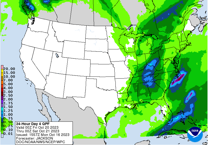 For a sneak peak at early season snow, check out our video forecast below. Hint: the smokies are a little white! We'll see improving conditions through Tuesday, sunshine Wednesday and a portion of Thursday, before showers return Thursday night through Friday, with lingering activity Saturday. Temperatures will also fall back into the 50s to low 60s this weekend to early next week. Good afternoon, the big topic we'll start off this forecast with is drought. Since the latest release, we have tumbled further down the hole, with severe drought now showing up in the southern valley. This is not good news as it relates to wildfire potential and water shortage/issues. We will be closely monitoring this moving forward, but I expect additional locations to become affected by severe drought in the weeks to come.  Changing tune, we are seeing cloud cover increase into the afternoon hours as a cold front approaches. The unfortunate news, as hinted above, is the very little rainfall that will be associated with this system. In fact, some may not see any rain at all. Activity will be hit and miss overnight and into Saturday, followed by the annoying and dreary: cold, cloudy, isolated shower/sprinkles. We will finally break the spell towards midweek, as sunshine returns and so does warmer air. Another system then looks to pose similar outcomes about a week out from now.  So about those temperatures...Many will struggle to break 60 degrees on Monday, with most in the low to mid 50s for highs. It will likely feel brutal, as there will be plenty of cloud cover around, an isolated shower, and temperatures upwards of 20+ degrees below average. The valley will see the best opportunity for mid to upper 50s, while outside locations struggle in the 40s to low 50s. 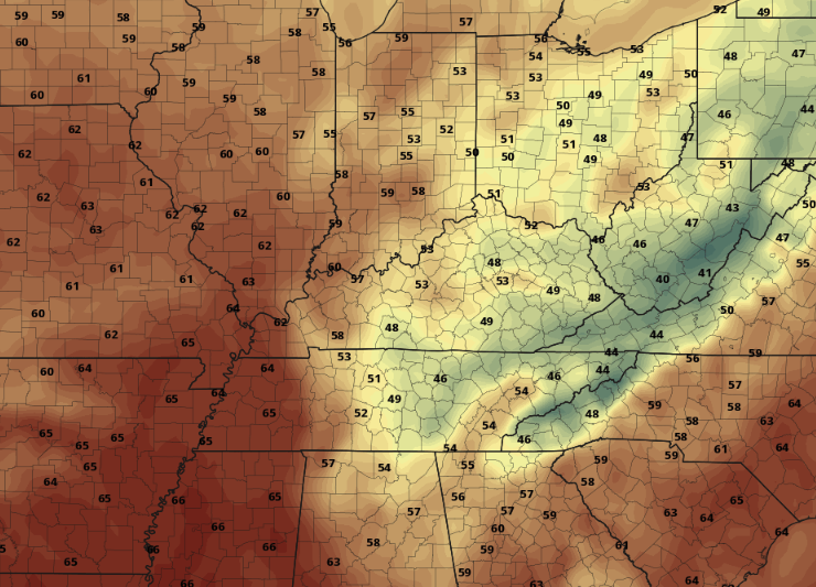 Prepare now to bundle up, as a cold front presses through tomorrow. This will be followed with well below average temperatures Sunday through Tuesday. We will finally see clouds break up through Tuesday, allowing for plenty of sunshine and warmer temperatures on Wednesday. Have a good one, stay warm, and look forward to Tuesday into Wednesday, as we'll finally get a reprieve from the dreary Fall days from Saturday through Monday.
Pre-recorded for a 5pm weather broadcast
An unsettled and overall cooler pattern will take shape through early next week, with rounds of rain and below average temperatures. As for today, cloud cover continues to push north and east as a system along and just south of the state meanders through. As a result, cloud cover will stick around much of the day, with isolated showers possible for those furthest south. Temperatures will feel cooler as well, with most topping out in the upper 60s to low 70s. Warmer air and more sunshine is on the way for Thursday though, with a change of mid and upper 70s expected tomorrow. 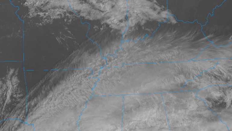 Looking at a concern we have mentioned that past couple of weeks: drought. This is the latest release for the state, depicting abnormally dry (yellow) and moderate drought (tan/brown). Rainfall amounts looks to be very minimal over the next week, with amounts up to a quarter of an inch possible. Rainfall will come best Friday night into Saturday, where lingering/annoying cool, cloudy, and isolated showers follow Sunday through at least Tuesday. With below average rainfall set to continue, the concerns for fire issues and related water shortage problems will grow in the weeks to come. 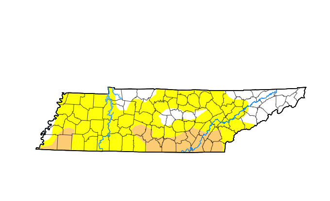 So what about this cooler air you are talking about? Well, a strong cold front will bring showers Friday into Saturday followed by a sharp drop in temperatures. Unfortunately, the upper level disturbance will linger across the eastern USA through early next week, resulting in periods of showers, cloud cover, and cooler temperatures overall. Below is a depiction of what we could see by Monday. This image is comparing average temperatures to those of what is expected....meaning we could see highs Monday 10 to 15 degrees below average in many locations. Prepare to bundle up moving forward, dreary fall days look to arrive this weekend. 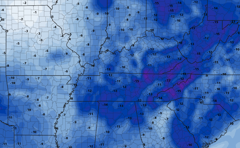 Cloud cover will thin out overnight, leaving partly cloudy skies for your Thursday. Temperatures will be warmer as well, followed by an approaching cold front Friday. This will bring likely showers to the area but with minimal rainfall amounts. Cooler air follows, lasting through at least early to mid week. Pre-recorded for 5pm weather broadcast
Pre-recorded for 5pm weather broadcast
Pre-recorded for 5pm weather broadcast
Pre-recorded for 5pm weather broadcast
Pre-recorded for 5pm weather broadcast
Good morning all! We will start off the day under mostly clear/sunny skies, but quickly see an increase in high coverage into this afternoon. Additional cloud cover will inch in from the west late in the day and overnight, as a disturbance approaches the region. As far as temperatures, one last day of very warm air with highs for many topping out in the mid 80s. Those south of I-65 could even find the upper 80s at a few locations. The good news? BIG changes coming by the weekend.  High pressure will begin breaking down today, as a strong cold front approaches from the west. As you can see below, the large blue area signifies the much cooler air post front across the Central Plains. This will slide east, bringing MUCH cooler air to East Tennessee late week. Highs Saturday and Sunday will struggle to break the mid 60s mark, while overnight lows will be very chilly. Values in the upper 30s to low 40s can be expected, with higher terrain closer to freezing. As such, FROST will be an issue for cooler spots this weekend. Make sure to bring in those plants or cover them Saturday and Sunday nights. 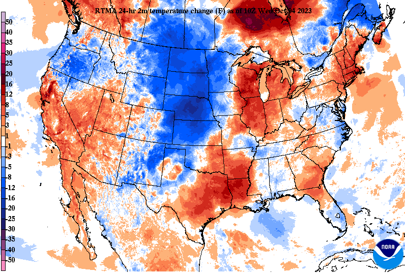 Aside from the the changing airmass, precipitation will be limited with this system. It will weaken as it sweeps through the Ohio Valley, leaving only isolated to scattered showers. Some may not even see rainfall at all, and those that do, only amounts up to a tenth or two. This is not much when comparing where we should be with rainfall and where we are in reality. Furthermore, the Weather Prediction Center is highlighting "Rapid Onset Drought" for a great portion of TN and south as we get into late October. This is not good, especially as this is our "Fire Season." Rainfall potential after Friday looks very lean and unpromising, so drought is likely to increase/expand in the weeks to come. Hopefully we see a change up later in the month and into November, or we could be dealing with wildfires and other issues in the near future. 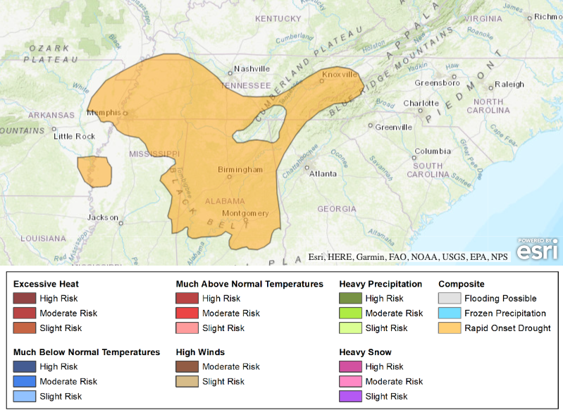 The forecast remains steady state for today, but the onset of changes will find us tomorrow. A few showers or an isolated storm can't be ruled out Thursday night into Friday, followed by much cooler air into the weekend. Enjoy!
|