|
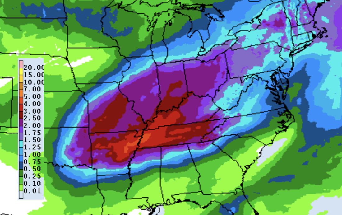
A beautiful morning across the Volunteer State as we start most sunny and generally stay that way through the day. Other than a few high clouds it should be a pleasant one with highs warming into the upper 60s and low 70s. Take advantage of the sunshine today into tomorrow, as it'll be the last we see of it until the weekend. Looking at model guidance, there still remains quite a bit of uncertainty regarding our next couple systems. Up first is the one arriving late tomorrow (really tomorrow evening and overnight), followed by a second one Thursday into Friday. System number 1: A cold front will pull east tonight into tomorrow, where cloud cover will increase throughout Wednesday. This will eventually lead to showers as a warm front builds north Wednesday night. Some activity Wednesday night into Thursday could be strong to severe, with gusty to damaging winds and heavy rain the main threats. Several inches of rainfall will pose both a flash flooding risk as well as a river flooding risk between Wednesday night through Friday night -- have a way to receive watches and/or warnings if they were to be issued. System number 2: With heavy rain in the realm of possibilities Wednesday night into Thursday, this second system could add to the fire. This will be particularly so if we see thunderstorms develop (which is likely). The good news is better agreement on a low track well north and west of the area favors lesser rainfall locally. There will be a brief break sometime midday Thursday (at least lesser shower chances) before activity picks back up Thursday afternoon and evening. Heavy showers and a few storms will be best Thursday night into Friday. We will continue to monitor trends moving forward and provide the latest here and on Twitter/Facebook. Looking at the rainfall amounts from the Weather Prediction Center, we are talking ranges of 2-4". These will be highest the further west you go, but still a soaker no matter where you are. Again flash flooding and river flooding will be a concern, particularly for locations that have passing thunderstorms and repeated activity. Enjoy the last of the sunshine and dry conditions, as showers and storms return Wednesday night through Friday. By the weekend, a post cold front airmass will allow for drier and much cooler conditions. Highs will be near average Saturday, moderating Sunday and into early next week. Check out more details below: Pre-recorded for weather broadcast
0 Comments
Leave a Reply. |
Your trusted source for everything weather in East Tennessee.
Social Media
|


