|
The biggest concern today and Thursday will be the heat. With high temperatures this afternoon topping out around 90 degrees, along with dew points in the 60s and 70s, heat indices will feel closer to the upper 90s. Some locations will even push the lower 100s. Keep your heat safety in mind today and again tomorrow, before cloud cover and rainfall cools things down a tad Friday and the weekend. 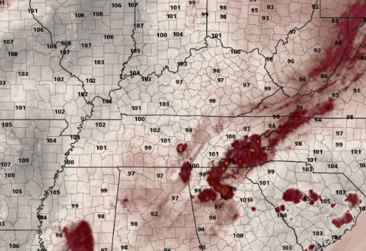 In terms of rainfall, we veer drier today with only an isolated shower or storm. By tomorrow, things begin to pick back up, with a cold front approaching from the west. The Weather Prediction Center has highlighted a Marginal Risk for flash flooding Thursday (late) and again for Friday. Given the rounds of rainfall we have already picked up, some locations will be more flood prone than others. Be weather aware both in terms of the heat as well as the rainfall tomorrow and Friday. 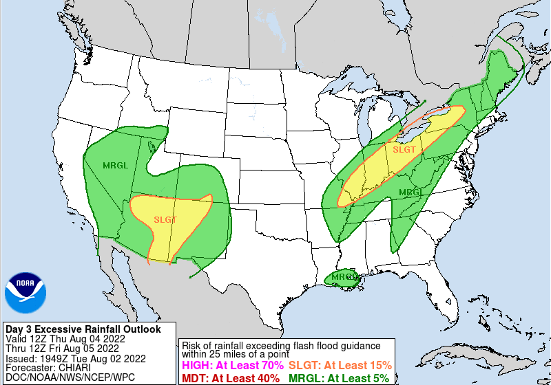 Laying it all out, showers will be isolated today, becoming more scattered Thursday. Chances will continue to increase overnight Thursday and into Friday, with most locations likely to see some rain to end the work week. Scattered activity will then linger throughout the weekend and into early next week, with the best chances during the afternoon to early evening hours each day.  Though activity won't be as widespread and consistent this weekend and into next week, have the umbrella on standby. Chances are you will encounter a few storms here and there. As far as today through Friday, the heat will be the biggest concern, with rain/storm chances picking up each day through the 3-day stretch. Pre-recorded for 5pm weather broadcast
0 Comments
We have started off warmer today, with current temperatures in the lower 80s (12:30 pm). Afternoon highs will also reflect the warmer conditions, with things topping out in the upper 80s. Combining this with the higher dew points, heat indices will feel closer to the mid 90s. Heat and humidity will continue Wednesday and Thursday, with heat indices climbing to around 100 degrees each afternoon.  Looking at the current forecast, UV index values will be between 9-10. This is high, so be sure to keep that sunscreen close by tomorrow and Thursday! Cloud cover will aid in lowering things (as well as temperatures) Friday and into the weekend. 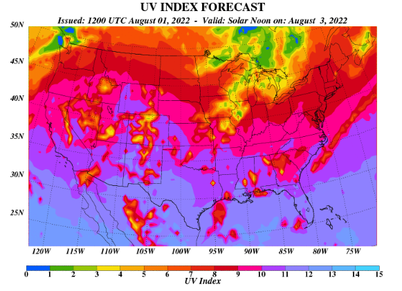 As far as what can be expected ahead, our usual summer-time pop up activity. Pop up showers and storms will be possible this afternoon, Wednesday, and again Thursday. By Friday, an approaching front will bring better chances, which also continue into the weekend. High pressure then fills in thereafter, bringing warmer but drier conditions next week. 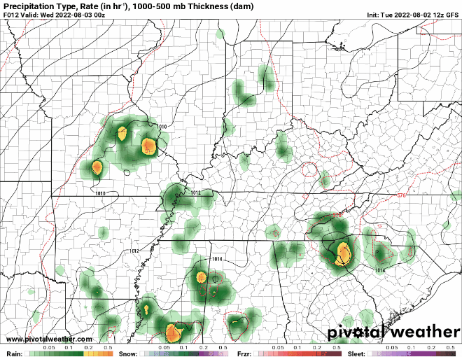 That will conclude the forecast for today, as always though, thanks for following along! Don't forget to share our content as well as follow us on Twitter & Facebook if you don't already. You can do so by finding us at @SecretCityWx Pre-recorded for 5pm weather broadcast
Good morning! Starting first with the latest state drought map....we have seen quite a bit of rainfall on and off the past several days, but the same can't be said in West Tennessee. Limited rainfall has led to Extreme Drought for portions of the state, while the remainder sits in Severe and Moderate drought. This will be something to watch moving forward, especially with East Tennessee back to normal. 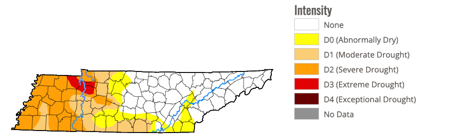 In terms of weather ahead, our active streak continues. Rounds of showers and storms will find us through the day today, before things quite down tonight. Redevelopment takes place into Tuesday, though activity will be more isolated to scattered. Higher Resolution guidance depicts an opportunity for a line of storms Tuesday night into Wednesday, so we'll have to keep a close eye on how things evolve. For now, look for Wednesday to be the quietest day, before increasing chances return Thursday and into the day Friday.  I want to take a second to also apologize for the gap in coverage late last week and into the weekend. I was apart of those who were stuck in Eastern Kentucky and dealing with the historical flooding taking place. With no phone reception, it was impossible to update you all on the latest (here, social media, or elsewhere). Thank you for understanding! Check out the video forecast below for more: Pre-recorded for 5pm weather broadcast
|