|
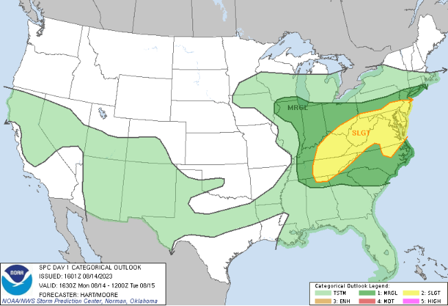
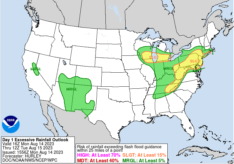
Scattered showers and storms seen across East Tennessee early this afternoon. A brief pause in activity can be expected now through the next couple of hours, before redevelopment later in the afternoon and through the evening. Highs today will warm up with increasing sunshine, topping out in the upper 80s. 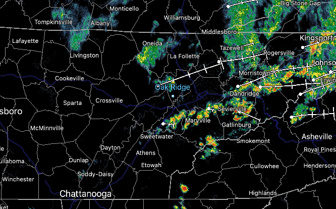 Looking at the risks for today, both a severe risk and flash flooding one are in place. With sunshine steadily returning from south to north at this hour, energy will increase across the area. This will set up the opportunity for strong or severe storms as we had into this evening. Additionally, heavy rainfall over the past week has resulted in soaked soils. As a result, flash flooding will be easier to come by. This is especially so for any showers/storms that work over the same locations. Have a way to receive warnings through early tonight.
Moving forward, a big change is expected. After a rather unseasonably active July into August, a strong area of high pressure looks to press in from the west. This could result in both an extended period of dry weather, along with warm temperatures. We will see the start of this intruding by mid week, with the center of the upper ridge filling in by late weekend. This could bring us the warmest temperatures of 2023 so far. We will see how it all plays out, but the risk is certainly there over the next 7-10 days. 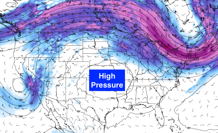 Stay weather aware today. With strong or severe storms and flash flooding possible, have a way to receive alerts and know your plan of action. Damaging wind gusts are the main concern, but a few instances of large hail or tornadoes can't be ruled out. Timing for the strongest storms will be between 6 PM and 2 AM. Activity decreases tonight into Tuesday morning, where generally dry conditions follow us out through the end of the work week. Pre-recorded for 5pm weather broadcast
The Smokies are living up to their name early this afternoon, as low clouds and fog have been slow to burn off here. Across the valley, partly cloudy skies prevail, but spotty showers and storms are starting to pop up across the plateau and drift east. Activity will dissipate into tonight, leaving another opportunity for patchy dense fog into Saturday morning. 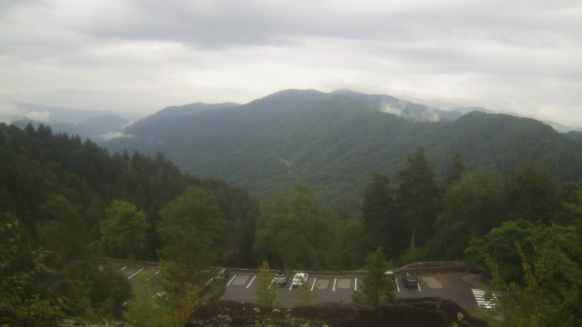 Looking ahead, a series of approaching disturbances are in the forecast this weekend to early next week. Though a few strong storms and/or heavy rainers are possible Saturday and Sunday, the better chance will be Monday ahead of an approaching frontal boundary. The Storm Prediction Center has highlighted a Day 4 slight risk across the northern plateau, where a general risk is likely for at least a portion of the area as we get closer. There are some uncertainties in timing as well as available energy, something that will be closer inspected this weekend. For now, be weary of the threat during the afternoon hours of the new work week, with damaging wind gusts and some hail the main concerns. Drier air then returns toward midweek and beyond. 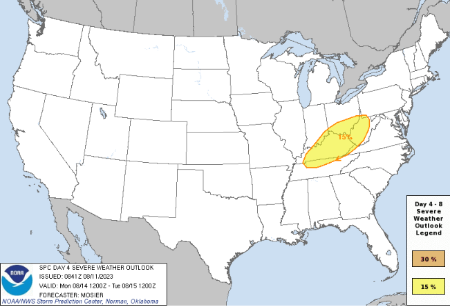 Changing tune, Hawaii has been in the news lately for its wildfires- specifically across the island of Maui. A big player in that issue has been the winds from Pacific Hurricane Dora. A strong pressure gradient from the system has resulted in high winds, and thus, a lack of control in wildfire growth and spread across the island. The good news is this hurricane will continue westward today into the weekend, with resulting winds slackening across the island chain. This will enable crews to get better control of the wildfires, and hopefully put a close to the activity in the days to come.  Scattered showers/storms will be possible this weekend, mainly during the afternoon and evening hours each day. Temperatures will also warm back up, topping out in the upper 80s to low 90s for some. Monday will be the best day to focus on in terms of strong or isolated severe chances, so tune back in for further details along with following on Twitter/Facebook. A few instances of flash flooding also can't be ruled out. Drier air then returns later Tuesday and towards midweek. Have a wonderful weekend everyone! Pre-recorded for 5pm weather broadcast
The results of Monday's widespread severe storms are in! Upon investigation, the NWS has determined an EF-2 tornado crossed Pellissippi Parkway just north of Turkey Creek and south of Pellissippi State Community College. The tornado path length was just shy of 4 miles, with a time on the ground of 8 minutes. Several other areas experienced damage as well, but it was determined to be straight line winds. I will post further details if other data is released. 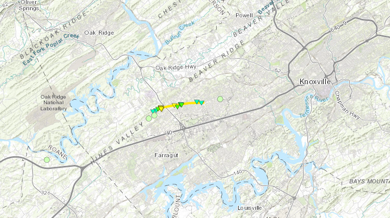 Moving back into the forecast, check out our drought map. If you recall a couple of months ago drought being an issue, well look no further. With several bouts of heavy rainfall experienced since the start of July, only nuisance abnormally dry spots are noted across the state. No worries of drought moving forward, especially after last nights rainfall, but climate prediction center outlooks do suggest drier than normal conditions are ahead for mid to late month. 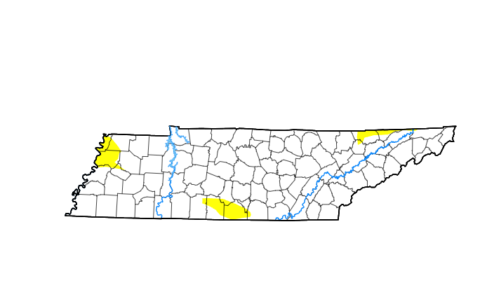 In terms of the rainfall potential ahead, isolated showers will continue to fade into this afternoon. Cloud cover will be slow to respond, but a return to partly cloudy skies is expected by late afternoon into the evening and overnight. Our usual pop up afternoon/evening activity will then primarily return ahead (Friday through early next week), with temperatures warming right back up into the upper 80s to low 90s this weekend. A few strong storms can't be ruled out Sunday afternoon/evening as a boundary approaches from the north, but the bulk of activity stays closer to the Ohio Valley. Drier weather looks to return about a week out (next Wednesday). 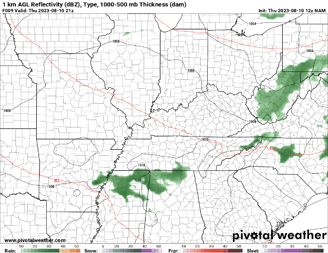 Check out our video forecast below for more details on the forecast ahead. Have a good one, enjoy warming temperatures tomorrow and through the weekend, and have an umbrella handy incase widely scattered showers/storms find you in the days to come. Pre-recorded for 5pm weather broadcast
Another passing disturbance brings strong & severe chances along with a flash flooding risk. Clouds increase this afternoon, leading to showers this evening and through the night. A few storms could become severe in the middle of the night, with the timing of this strong activity between 2 AM and &7 AM. Have a way to receive warnings, especially during this part of the night. Activity wanes into Thursday, with mainly scattered activity mid morning and through the afternoon. Additional showers & storms will follow Friday and through the weekend, with scattered (30-50%) chance each day. Temperatures warm back up near 90 degrees into the weekend as well. Stay safe, have multiple ways to receive warnings overnight (particularly for the plateau and southern valley), and know what to do if one is issued for your area. It turned out to be a very busy day across the Southeast, with hundreds of storm reports noted. As you can see below, the bulk of storm damage was in the form of winds, but hail, and possibly a few tornadoes are noted. I say "possible" because several NWS office's (to include Morristown) will be conducting surveys today and Wednesday. Stay tuned for the results of these investigations! 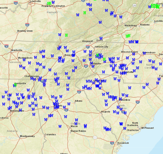 As far as today it will be pleasant. Cloud cover will be slow to exit, but once it does so through the morning and early afternoon, partly cloudy skies find us the remainder of the day. Highs will be a touch cooler, thanks to the front, topping out in the low to mid 80s. Moving forward, another disturbance is on the horizon. Thankfully this next system is not nearly as dynamic as the last, but will still pose a severe and flash flooding risk. A two-day flash flooding outlook has been placed across the area, with a slight risk (at least 15% chance) noted both days (Wednesday & Thursday). 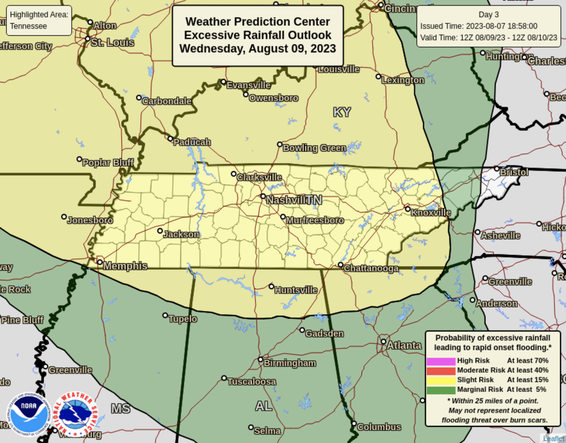 In terms of rainfall amounts, the average will range from 1-3 inches, with locally higher amounts likely within stronger thunderstorms. Have a way to receive warnings and know what to do late Wednesday and through Thursday. Scattered showers & storms then remain in the forecast Friday and through the weekend, with activity primarily in the afternoon and evening hours late week/weekend. Temperatures will also take a dip mid week (upper 70s to low 80s) followed by a rebound into the mid and upper 80s Friday and through the weekend. 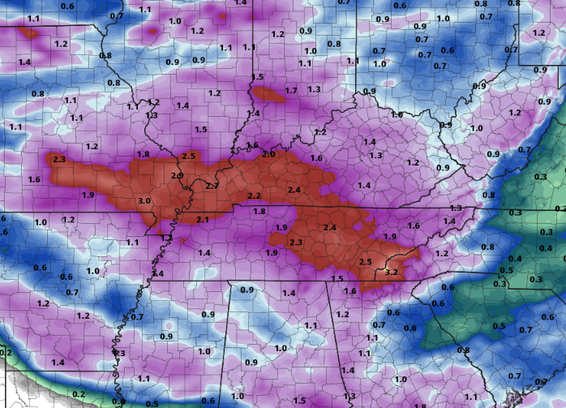 That will do it for today. If you have any reports (wind damage, hail, or possible tornado damage), please send that information our way. This information helps us know what is/went on, it helps the NWS with verification/insurance/official claims, along with spreading word to our other viewers on impacts seen. To send reports, mention us on Twitter, Facebook, or send us an email including what happened, where, and roughly what time (if possible). Pictures are ALWAYS welcomed as well!
Strong and severe storms become increasingly likely into this afternoon. All severe weather hazards on the table: damaging wind gusts, large hail, and a few tornadoes. This is a very "spring-like" setup and certainly abnormal for this time of the year. Remember what to do (and start planning now) if warnings are issued. The timing for activity will be best between 12 pm and 6 pm today. Activity lingers into this evening, otherwise clearing skies through Tuesday. Showers and storms again return mid week, where a few strong storms and a risk for flash flooding presents itself Wednesday and Thursday. Stay safe and pass along any reports you can to us via Twitter, Facebook, and Email today. High pressure brings decreasing rain chances and cloud cover throughout the day today, leading to partly cloudy skies and warm temps for Saturday. A anomalously strong low pressure system and cold front then bring the opportunity for strong storms Sunday and Monday, followed by our usual summertime pop up afternoon junk Tuesday and Wednesday. Winds could be gusty on Monday for some. Check out more below: Pre-recorded for 5pm weather broadcast
|