|
Pre-recorded for afternoon broadcast
0 Comments
Patchy fog for some as we start off the morning, otherwise mostly clear across East Tennessee. Check out the disturbance upstream to the northwest though, broad cloud cover and heavy showers associated with that complex but will weaken and dissipate through the morning hours. That said, blow off clouds from the system will pass into our area, where increasing cloud cover will be the trend today. Most will steer dry through this afternoon, with shower chances picking up this evening, overnight, and into Thursday. 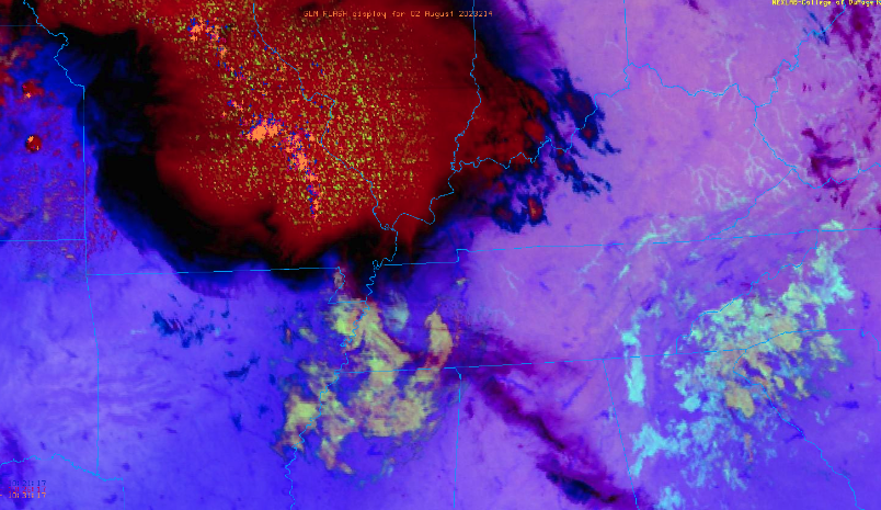 Looking at our next series of disturbances, our first arrives tonight into Thursday followed by several more thereafter. As a result of the rounds of rainfall expected, a Slight risk of flash flooding (at least a 15% chance) has been put in place for the entire area. Rainfall amounts have generally stayed the same as yesterday, so we are up-ticking from our original amount to say 2-4" will be possible. These higher end amounts look more promising across southeast Tennessee. With all warm season complexes, higher amounts will be possible especially for any locations that see repeated rounds of activity. Have a way to receive warnings, as heavy rainfall could leave to flooding and a few isolated strong storms could become severe. Again the primary timeframe for heaviest rain will come Thursday to Friday night, followed by scattered (mainly afternoon) activity Saturday and Sunday. 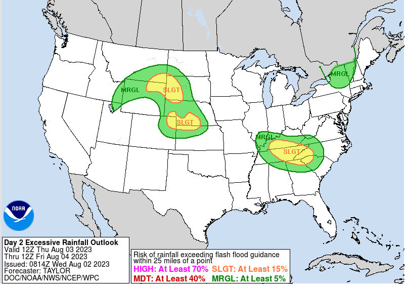 Checking out those rainfall totals for yourself, you can see the trajectory of storms over the next couple of days. A northwest to southeast line is favored, following a line from Western Kentucky to Northwest South Carolina. Because some areas are more flash flood prone (recent rainfall, lower lying, type of terrain, etc.) than others, be sure to stay alert and have several ways to receive warnings- especially in the overnight hours. 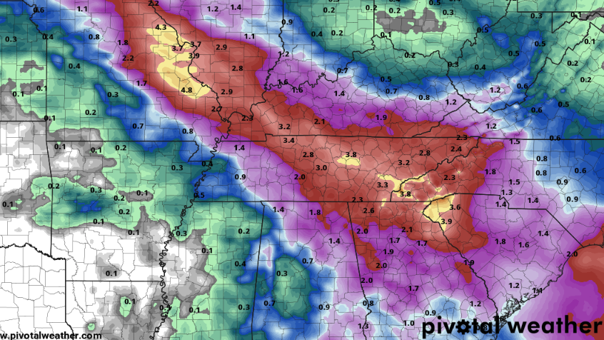 That will do it for today....be sure to check back in for the latest on rainfall and the flash flooding threat. Confidence continues to grow a soaking rain is likely, which could result in scattered instances of flash flooding/flooding. Be alert starting tomorrow and don't hesitate to pass along any reports!
Good morning! Another pleasant day is in the works, with highs topping out in the mid to upper 80s under most sunny to partly cloudy skies. Most will stay dry but a very isolated shower can't be entirely ruled out for the higher terrain this afternoon. As far as the image below, the Tropics remain active. The National Hurricane Center identifies two areas of concern, one of which bares a 40% chance of formation in the next 48 hours. The good news is both are expected to march northward, with little impacts to the CONUS.  Moving forward, our sights are set on our next disturbance. High pressure sits to the north, but will pull out through Wednesday. This will leave a stalled boundary hanging just south of the area, where low pressure will develop along it to the west and slowly work east with time. Moisture will return ahead of this system, where isolated to scattered showers will start as soon as Wednesday. The best chances come Thursday into early Friday as the low slowly works across portions of the area. Scattered activity will remain possible Friday afternoon through the weekend, but generally becomes more of our usual summertime pop up junk Saturday and Sunday. Temperatures will also rebound into the upper 80s to around 90 Saturday and Sunday. The biggest concern moving forward will be the threat of flash flooding and/or gusty thunderstorms. Looking below, the WPC has upgraded the area to a slight risk for flash flooding. With a slow moving low pressure system on a quasi-stationary boundary, rounds of showers and thunderstorms will be a concern through Thursday. Those that see repeated activity (training) will pose the biggest threats of excessive rainfall. 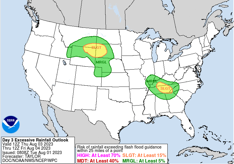 For those that missed our post yesterday, rainfall totals were generally in the 0.75-1.75" ballpark. As of this morning, WPC suggests this estimate has almost doubled. There remains some uncertainty in the true path of the low and associated boundary, so will hold to 1-2" until clearer data arrives, but do be weary of heavy rainfall potential to come. Have a way to receive warnings if they are issued and be sure to check back in for the latest on amounts and any severe weather potential (low right now). 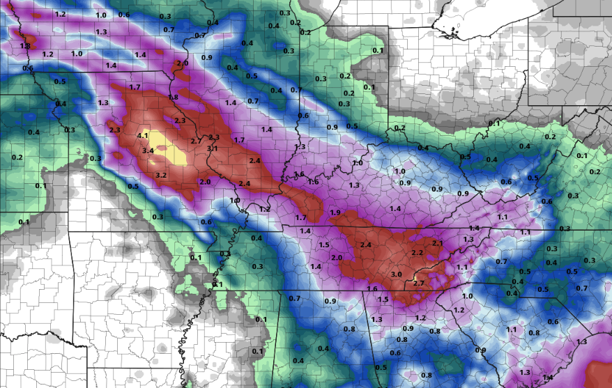 Have a good one, enjoy another beautiful day, and tune back in for the latest regarding heavy showers/thunderstorms later in the work week. Pre-recorded for 5pm weather broadcast
|