|
Another comfortable day is ahead with high's to top out in the mid to upper 70's. Shower activity will be limited to the smokies but a stray shower early this afternoon can't be ruled out entirely. 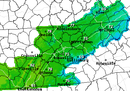 The latest surface map shows the low off the coast of South Carolina slowly working north and providing lots of rainfall for the eastern coast line. The good news is the Smokies act as a "buffer" shielding us from lots of that rainfall at home. As this system works back northward, wrap-around scattered showers will arrive later Wednesday and into the day Thursday. 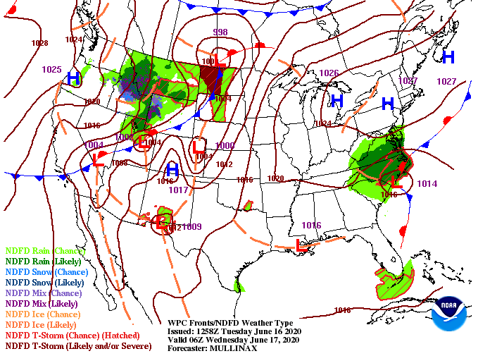 Taking a look at what I am referring to, showers will stay contained to the Carolinas today and much of tomorrow before widespread activity is likely Thursday. For now, I think this model in particular is "over-hyping" rainfall throughout the region so we are giving it a 40% chance through the day. Depending on how much moisture is still retained across the area and where the low moves will depend on shower chances. Jumping into the weekend, a high pressure system will slide in (later Friday) clearing things up and increasing the overall temperatures. The 90's will more than likely return for the majority of us this weekend as humidity values climb as well.  As I mentioned yesterday, take advantage (especially today) of the sunny skies and comfortable temperatures. We are nearly 5 to 10 degrees below average for this time of the year and that's expected to quickly change in the next few days.
0 Comments
A front has allowed for very comfortable temperatures to start the new work week. High's today and tomorrow will be in the upper 70's before the heat and humidity return Friday and the weekend. A look at what's going on below shows a low residing over northern TN/ southern eastern KY. This will slide south through today providing isolated shower/ storm chances this afternoon. 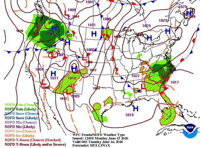 A sneak peak at your 4 o' clock temperatures show upper 70's here in the central valley and low to mid 70's for those in the higher elevations. Overall, today and Tuesday will feel great for this time of the year. We average high's in mid-June in the mid to upper 80's, so we won't complain about temperatures 7 to 10 degrees below average. 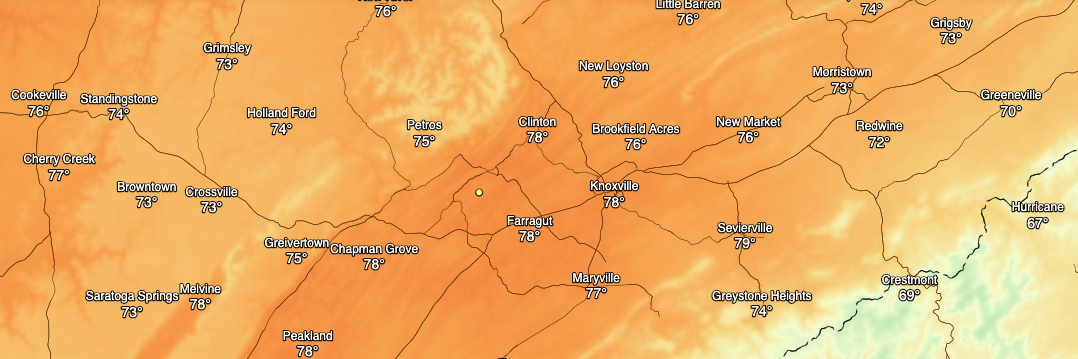 On the flip side, changes are on the way. The low currently residing in northern TN will meander south and east to the Carolina's coast line. It will then push north by Wednesday and Thursday bringing isolated to scattered showers. By Friday, a high pressure system will fill its place drying things out and warming things back up. High's, unfortunately, will return to the 90's here in the valley with humidity values on the rise as well.  Take advantage of these seasonably cool temperatures before the 90's return later this week and into the weekend. A few showers could be stronger at times this afternoon so be weary, otherwise enjoy partly cloudy skies and high's in the 70's. Tuesday looks to be beautiful with shower chances staying isolated to the mountains. Wow, how about this gorgeous view of the Smokies from the Newfound Gap cam this afternoon?! This is a good glimpse into how conditions will be for this weekend. 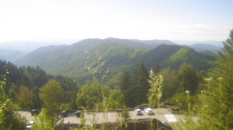 Temperatures to start the weekend will be nearly the same as today with high's topping out in the low to mid 80's. A high pressure system (to the west) remains in place keeping things rather peaceful. A weak cold front from the north will slide through the later part of the weekend keeping temps mild in the lower 80's (Sunday & early next week). Do be mindful a pop up shower is possible Sunday afternoon but the vast majority of us will stay dry with lots of sunshine overhead.  Taking a look into the future, precipitation is expected to remain well below the average for this time of the year. Not only will this impact us at home, but much of the deep south will be drier than normal over the next 6-10 days. We will keep a close eye on this as we near the summer time months and if any drought conditions begin popping up.  That will conclude today's forecast; have a fantastic weekend! If you would like to share any outdoor adventures with full credit to you, share your pictures by tagging us on social media or sending them to SecretCityWx@aol.com Thankfully, a cold front moved through late last night providing much needed relief from the heat and humidity we have been dealing with the past several days. Looking below, we are nearly 10-15 degrees cooler now than we were yesterday. 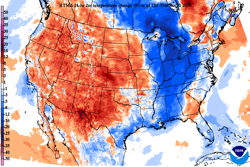 In addition to the cooler temperatures, dew point values are much lower as well. Looking into eastern North Carolina, we were in the low to mid 70's yesterday but now in the mid 50's. That is a dramatic change in comfort associated with the drier air post cold front. 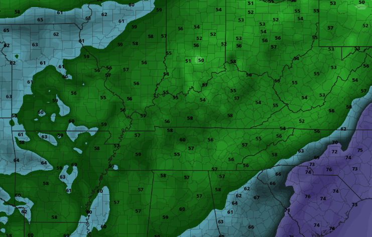 To finish out the work week and weekend, little changes are in sight. Major ridging is taking place over the eastern half of the US giving way to peaceful weather conditions for the greater part of the country. A secondary (weak) front will arrive for the middle part of the weekend keeping temperatures near average early next week. 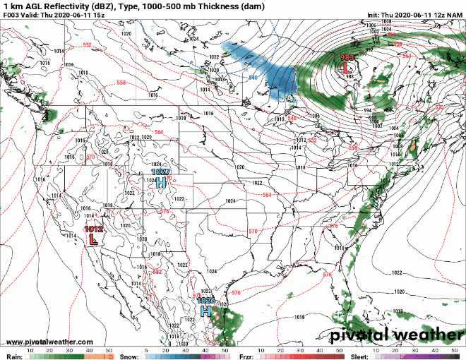 If you don't already have outdoor plans made, this would be a great string of days to do it. Sunny skies and highs in the low to mid 80's are anticipated over the next 5-6 days, so take advantage if you have the chance! A marginal risk remains in place this afternoon as showers and storms are expected to develop this evening ahead of a front. The heavier showers and storms today will be scattered with a developed line (ahead of a cold front) likely staying into the northern valley and into Kentucky. With that said, the timing for activity will fall between 4pm and 9pm tonight. Gusty winds and small hail are the biggest impacts through the evening hours. 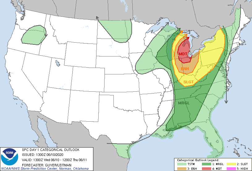 Activity will begin picking up this afternoon as a cold front from the west draws near. As mentioned, the best chance for storm activity falls into the late afternoon to evening timeframe before clearing takes place overnight. In the days ahead, sunny skies, average temperatures, and low humidity will be present.  Take a look at the future temperature map late tonight/ early into Thursday. You can definitely see where that cold front lies with a 10+ degree temperature swing from North Carolina to Tennessee. Cool air will stick around Thursday and Friday with high's in the low to mid 80's. Working into the weekend, a secondary front will keep things comfortable Saturday and Sunday. 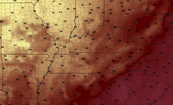 Check in this afternoon with us on the latest regarding the showers and storms. Though severe potential remains low, gusty winds and hail can still be an issue for some. As long as you can make it through today, beautiful conditions are in store for the days ahead. Cristobal continues to work north providing cloud cover and a few isolated showers across east Tennessee. Expect this to continue through the afternoon before fading out overnight. Working into Wednesday, a cold front will provide widespread shower and storm activity in the afternoon and evening hours. 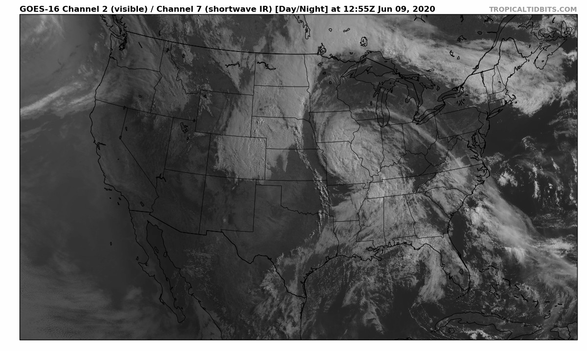 The day 2 SPC outlook highlights a marginal risk for the eastern half of Tennessee, so be weary tomorrow afternoon. A few heavier showers/storms will likely produce gusty winds and hail at times. The good news is once the front moves through, it is smooth sailing in the days to follow. 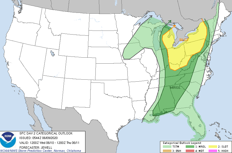 Checking out the model guidance, shower activity will be on and off tomorrow with the heaviest batch likely on the leading edge of the front. Timing for showers will be from late morning through the afternoon before heavier shower/storms are likely into the evening. Once the front passes, cooler and drier air will fill its place. 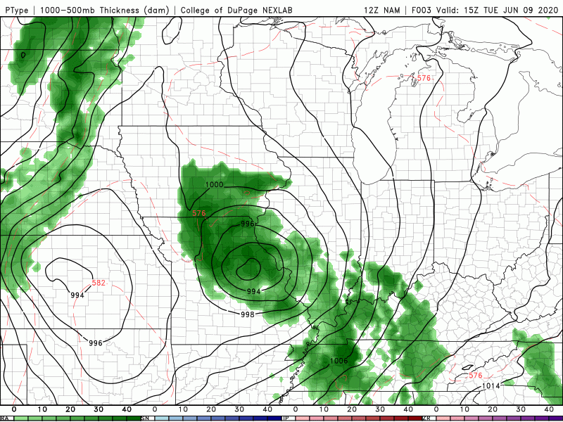 If you don't already have plans set for this weekend, you may want to make some. Thursday through early next week will be beautiful with at to slightly below average temperatures and plenty of sunshine. If you take a look outside you'll see the cloud cover associated with tropical depression Cristobal. This system will continue working north the next couple of days, eventually bringing scattered rainfall chances later Tuesday and Wednesday. Outside of this tropical system, make sure you are staying cool and hydrated today. High's this afternoon will be in the low to mid 90's and feel-like temps will be pushing the triple digits for some. There is good news working ahead as we'll finally get a break from the heat and humidity later this week. A cold front working in from the west will move through late Wednesday, providing cooler and drier air Thursday and Friday. A secondary front into the weekend will keep temperatures at to slightly below average Saturday and Sunday. 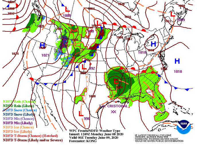 The first half of the week will be muggy, warm, and wet at times, so be prepared. As Cristobal moves north, some of the outer bands of precipitation will impact east TN tomorrow and early Wednesday. A better chance for showers (and a few storms) will appear Wednesday as a front closes in. By Wednesday night, skies will begin clearing as cooler air and sunshine return for Thursday and through the weekend.  If you can make it through the first half of the work week, the second looks to be beautiful! As always, more details can be found in our daily forecast video below. Have a good Monday! Shower activity is beginning to die out as we work into the early afternoon hours with sunshine to quickly return by early this evening. Looking ahead into the weekend, above average temperatures will return and continue into early next week.  A look into Saturday shows high's likely in the lower 90's for the central valley. The southern valley will likely feel a few degrees warmer, so take the proper precautions for your heat safety. The average high in Knoxville this time of the year is 83, so temps will be nearly 10 degrees higher Saturday through Tuesday. 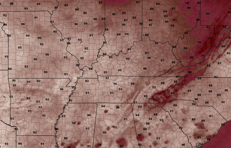 The path of Cristobal remains much of the same. Landfall is anticipated late Sunday/ early Monday where it will continue moving north. By late Tuesday/ early Wednesday, Cristobal will veer right. This is where we will see our next likely rainfall event. In addition to the scattered showers expected mid-week from this system, Cristobal will also break the extreme heat expected the next several days. 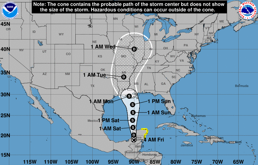 Be sure to keep your heat safety in mind this weekend. Drink plenty of water, take frequent breaks (if working outdoors), and stay cool. Have a good weekend and stay safe! The first 90 degree day of the year was recoded yesterday with Chattanooga topping out at 92 degrees. Luckily, we'll see a bit of a break today with high's in the mid 80's, but this won't last long. Temperatures through the weekend, especially Sunday and early next week, will be in the lower 90's in the central valley. 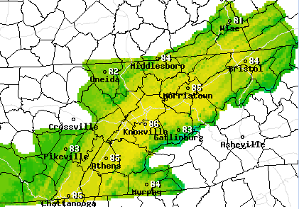 So far today, things have stayed quiet around the region. That will begin to change this afternoon though, as showers and storms develop and move through. They will be scattered in nature with a few heavier storms likely at times. Friday will be much of the same, partly to broken cloud cover with isolated to scattered showers (mainly in the afternoon). By the evening hours tomorrow, conditions will clear with sunny skies returning Saturday and Sunday.  Cristobal has weakened down to a tropical depression but is expected to regain strength as it works north in the coming days. Landfall is expected in the US sometime late Sunday to early Monday in parts of Louisiana and Mississippi. Once on land, the tropical system is expected to move north before breaking eastward in northern Arkansas. As Cristobal turns right, east TN could feel some of the impacts by mid next week. We'll continue to eye this in the coming days and let you know the latest!  That concludes today's forecast but if there is anything Secret City Weather can do for you, shoot us an email at SecretCityWx@aol.com and we will be happy to help! As we near the 11 o' clock hour, temperatures are already in the upper 70's to lower 80's. The average for this time of the year is 82 but we are expecting temps to top out today around 90. Muggy conditions will also be present so have plenty of water and stay cool this afternoon (especially those outdoors for long periods of time). 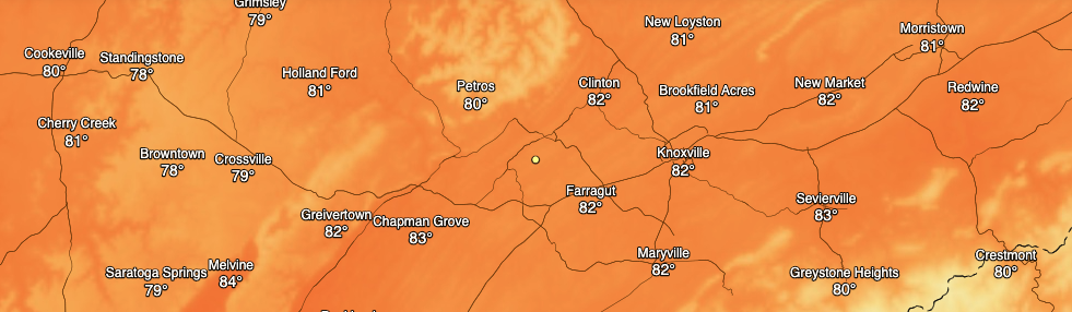 A bit of a break comes tomorrow as a low pressure system draws near. Scattered showers are expected to arrive by late-morning to early afternoon and continue on and off into the evening hours. Scattered activity will continue into Friday before more sunshine returns for the weekend. Keep in mind there is a low chance for any severe activity tomorrow but some storms could contain gusty winds and small hail.  Jumping into the outlook for mid June, slightly cooler temperatures are anticipated. Keep in mind averages for mid June are the mid 80's so "cooler" is a relative term. We'll have to get past the hump this weekend and early into next week as high's will be at or around the 90 degree mark. 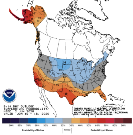 As always, we will keep you posted via social media for the latest on all your weather needs. For now, stay cool and hydrated as today will be much above average. |