|
I hope you are staying warm. We started the day with wind chill values in the lower teens for much of the valley. Into the higher elevations some cities were in the single digits to start the day, so very cold temps to be the middle of Fall. A cool feature satellite picked up on this morning was residual snowfall laying in east TN and to the north. Unfortunately, this will melt through the day today as we will have high's well above freezing this afternoon (lower 40's here in the valley).  With a high pressure system overhead, we will stay sunny today and gradually work ourselves back to average temperatures through the week. By early next week we will be back near 60 degrees and feeling a bit more comfortable. A disturbance to the north will bring in cloud cover tomorrow afternoon and into the first half of the day Friday before we clear out just in time for the weekend. No precipitation is expected with this system Thursday and Friday for the valley.  Below on model guidance is the latest cloud cover run. Dark values indicate clear skies while white to grey means cloudy conditions. As you can see, by Thursday afternoon overcast skies will be pushing in from the north and west. This will continue into Friday as well before clouds begin moving out Friday afternoon.  We will start the morning cold again for Thursday so bundle up! Temperatures will be in the lower 20's Thursday morning and eventually warm to high's near 50 by the afternoon. That will conclude today's forecast but stay warm today and tomorrow!
0 Comments
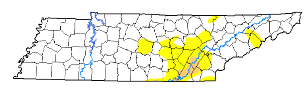
Blistery cold temperatures have arrived today and will only progressively worsen this afternoon. Even though temps will stay in the low to mid 30's this afternoon, a north wind (funneling in drier air) will make things feel in the 20's to teens across the board. The snapshot below shows wind chill values at 1 this afternoon in the mid 20's for the valley and teens for Plateau. The one piece of good news associated with the breezy conditions is the fact that it will dry out road ways lowering the chances for any ice to develop overnight. 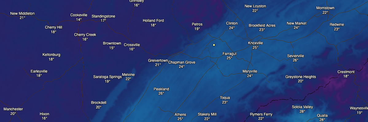 Better news is on the horizon though, as a high pressure system from the west will build in the next several days. This will gradually warm temperatures back up to near 60 degrees by early next week as well as keep things mostly sunny overhead. Keep in mind the average high for this time of the year is around 60 degrees, so we will stay below that for the work week. Into tonight, it is important to note we will likely set numerous low temperature records across east TN. For Knoxville alone the previous low (set back in 1987) was 20 degrees and we are looking to have temps drop to the middle teens overnight. Wednesday morning will be a COLD one so dress you and your children according. 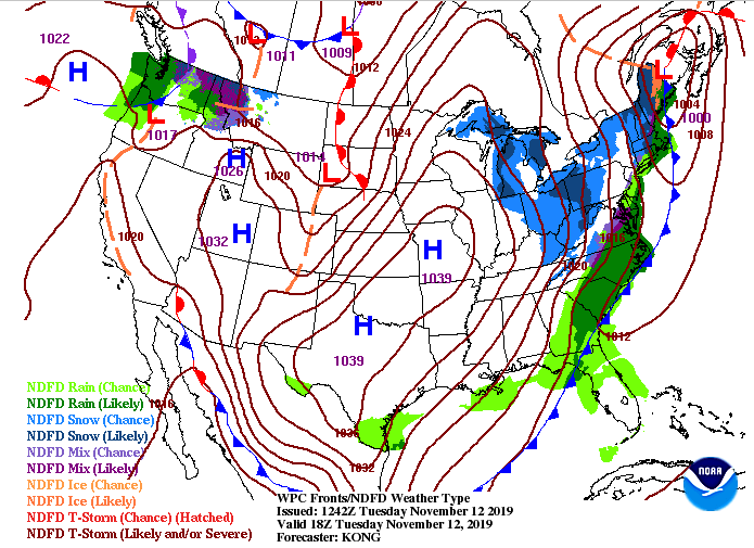 Model guidance suggests remnant snow showers into the early afternoon for the Smokies before the system moves entirely out and to the east. Tailing it, we will have a high pressure system move in clear things up and gradually warming the temps as we progress through the week. Overall snow totals varied but to paint a brief picture around the region, Anderson County received around half an inch in the Norris area, Blount county recorded nearly 2 inches, Washington county had 2 inches, and Claiborne county had just over 2.5. That should begin melting this afternoon and eventually fade out entirely by tomorrow with temps getting well above freezing.  That will wrap up your Tuesday forecast. Bundle up and stay warm as wind chills will make things feel nearly 15 degrees cooler than they truly are. Happy Veteran's Day! Thank you for all who have served and are currently serving to protect this great country. Getting into the weather across east TN, many changes are in the forecast for the next 24 hours. We have mostly sunny skies overhead now but cloud cover will increase from our west this afternoon. Showers will likely make a presence by late this evening before transitioning to wintry mix and snow by early Tuesday morning. As you can see below, the transition period will take place around 1am to 3am from west to east. 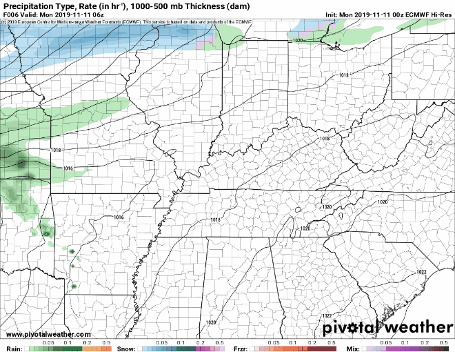 As I discussed in yesterdays post, topography plays a huge role in winter time events. The timing of the cold front and ground temperature also play a huge role for this weather maker. For this system, we are breaking down snow accumulations as followed: Plateau: Up to 1 inch of snowfall Central Valley: Trace to half an inch (grassy surfaces, vehicles and vegetation primary areas for any accumulation) Southern Valley: A few tenths of an inch of snowfall possible with the main threat of freezing rain & sleet Northern TN: Up to 1 inch of snowfall Foothills/Smokies: 2-3+ inches Keep in mind very warm temperatures (mid 60's) this afternoon will keep ground surfaces warm into the night. This is good news for morning commuters as most snow will stay off roadways. 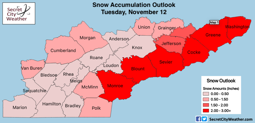 Into tomorrow morning and through the day, I advise using caution in the morning hours. As there will be a rapidly cooling temperatures tonight, patchy black ice will likely form, so slow down and account for some extra time. By mid-morning and through the afternoon, any ice will melt quickly allowing for pleasant road conditions the remainder of the day. 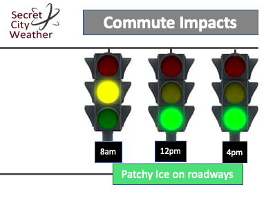 Don't forget to bundle up tomorrow as high's will only be in the mid 30's (nearly 25 degrees below average). By tomorrow afternoon expect mostly sunny skies to return and carry through the remainder of the work week (gradually warming back up each day). That will conclude todays forecast but be sure to remain weather aware and check back in for the latest details. (@SecretCityWX -Twitter & Facebook) Good afternoon everyone! I typically do not post on the weekends but given the upcoming system is rather interesting and could impact daily operations early to mid week, I thought I would provide my latest forecast and thoughts. Regarding this next system, we will have clouds build and move in throughout much of Veterans Day. Rain shower will arrive by the evening hours and carry on through the night. By early Tuesday morning an Arctic blast of air will arrive creating a transition phase from rain to frozen precipitation. The timing of this cold air arriving is still uncertain given the time period is too far out for some of the high-res short-term models. With that said, there will be a transition period across the board. As you can see below (just one model) rain will transition to snow early Tuesday morning, eventually petering out by the early afternoon (west to east).  Snow amounts will vary due to the topography but I do think all will see snow fall. As for the valley, I will keep totals on the lower end given the timing of the cold air is not in phase from model to model. The best chance to see snow accumulation will be in the Smokies and areas east of the valley. The latest models are narrowing in on the Plateau as the spot for snow showers to begin falling. Totals in this area (Plateau) will be up to an inch of snowfall. For the valley, expect (as of now) a trace to half an inch possible (higher totals for higher elevations). For northern TN, similar to the Plateau with up to an inch possible. Lastly, if you are in the Smokies or foothills (east of the valley) you will likely see 1 to 3 inches of snow into Tuesday. As you can see below, the "U" or "Horseshoe" effect is occurring (as it usually does with winter events). Warmer air is trapped in the valley while the higher elevations are much cooler. Topography plays a huge role in winter weather (and all weather) here in east TN making it challenging to pinpoint exact snowfall amounts per county.  Here is a rough outlook of the snowfall you can expect into the day Tuesday. Something to keep in mind from the above model guidance for accumulation is ground temperature. During the day Monday we will have high's around 60 degrees. Though the ground cools much quicker than other surfaces/ liquids, it will still take time for it to cool down quick enough for snow to stick. Basically, this means if model data is saying two inches for the Plateau it likely means only one inch will stick after the ground is to proper temperature. In addition to ground temperature, the air temperature will be around the freezing threshold here in the valley, so freezing rain could be the largest concern early Tuesday morning. By Tuesday afternoon, we will clear out leaving high's only in the mid 30's and breezy conditions out of the north. I hope this helps paint a better picture into Tuesday and if you have any questions don't hesitate to shoot us an email at SecretCityWX@aol.com. Enjoy the rest of your Sunday and have a great Veterans Day! We will continue to update you on the latest here and social media. Happy Friday to all! I hope everyone is bundled up as high's will only be in the mid 40's this afternoon. Beautiful sunny skies return though (as seen below). These conditions will continue through the weekend before our next system arrives early next week.  The cold front is being felt across the region with 20 to 25 degrees of change from this time yesterday. We will have another strong cold front bring Polar air into the region by Tuesday of next week with winter-like highs in the mid 30's. We could see several records broken here and throughout the eastern United States. 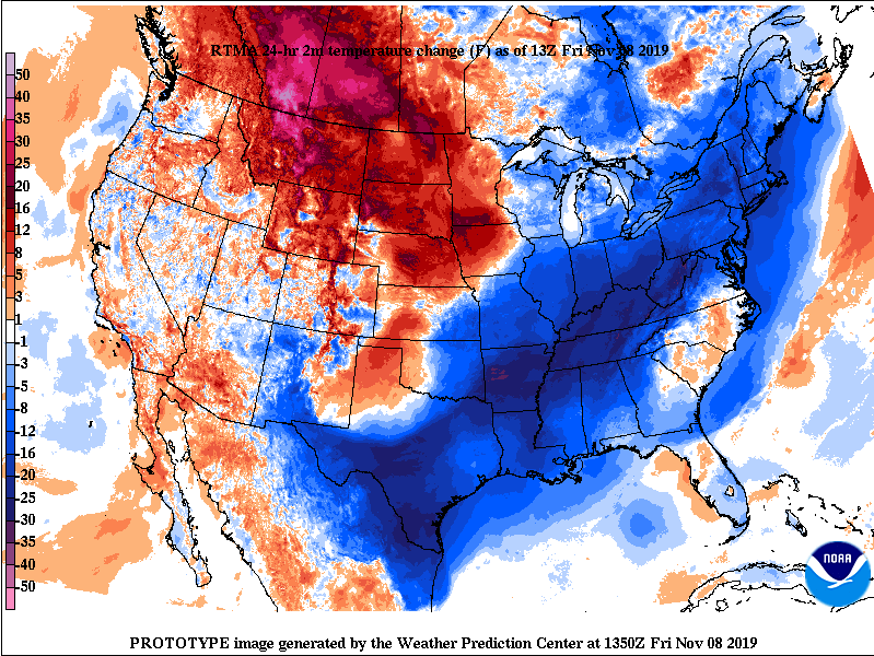 Through this weekend we will slowly warm up sticking with sunny skies overhead. By early next week (end of this gif) showers will begin moving in Monday evening/overnight before transitioning to frozen precipitation. Models continue trending toward the idea of rain transitioning to snow late Monday night and into Tuesday but this is all highly dependent on when the cold front moves in. The later the front is within the system, the more rain we will have. Oppositely, the sooner, the more snow potential there is. As we get closer to time we will have a better idea. Nonetheless, we aren't anticipating any accumulation in the valley but there is the likelihood in the higher elevations and into Kentucky. Keep in mind the general picture: COLD air Tuesday and Wednesday of next week. Along with the cold & likely breezy conditions, there is the potential for black ice and slippery spots on the road ways. 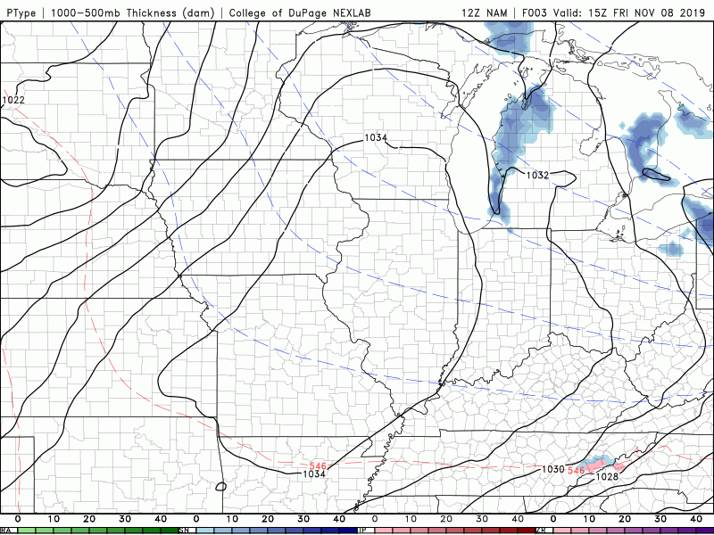 That will do it for Friday but have a great weekend and continue checking in on our social media (Twitter & Facebook) for the latest development of this next system. Kicking off Thursday with some improving news on the latest drought map. If you recall just two weeks ago parts of Chattanooga were under extreme drought conditions. The latest release shows the impacts all the rainfall has had with moderate drought the highest intensity we have across the state. With another round of showers today, expect these conditions to only improve.
As for the rain expected today, showers will continue moving in the next hour or so and carry through the evening hours. With a cold front back side, much cooler and drier air will funnel in tonight and into Friday. 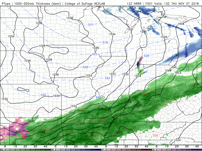 The latest surface map depicts the cold front to our west. This will slide in overnight tonight forcing moisture rich clouds east and clear skies to return to close out your work week. Cooler temperatures will stick around into the weekend before our next system makes an appearance Monday afternoon. As for this weekend, a high pressure system will keep things dry and mostly sunny. 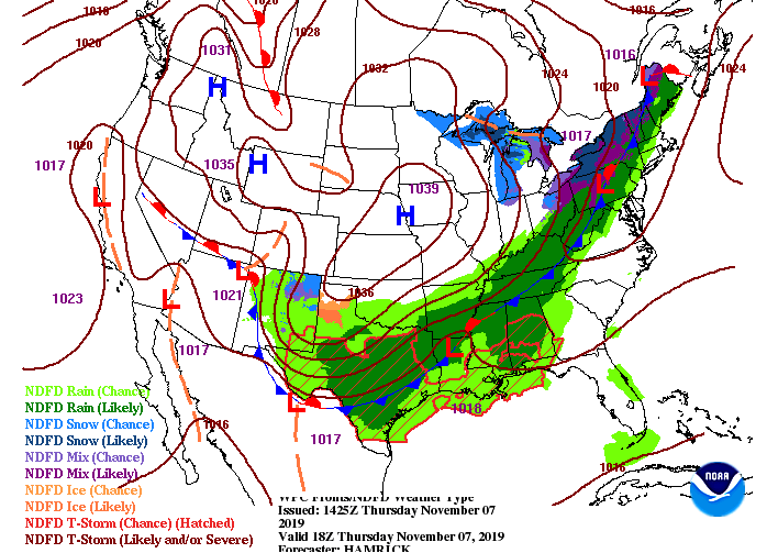 Cold front #2 could be an interesting setup as we peak into early/mind next week. Showers will arrive the later half of Monday where we could see a transition to freezing rain & snow overnight. With this next system we are NOT expecting any accumulation given the latest data and trends. With that said, accumulation is possible in the higher elevations (NE TN, Smokies, and Eastern KY). Though we won't have any accumulating snow in the valley, you will likely see a few flakes overnight Monday and into Tuesday. The main story line with this next system is the abnormally cold temperatures we will see mid week. Tuesday and Wednesday we will likely have high's in the 30's and overnight low's in the teens and 20's. Continue to check back for the latest development on this second system. 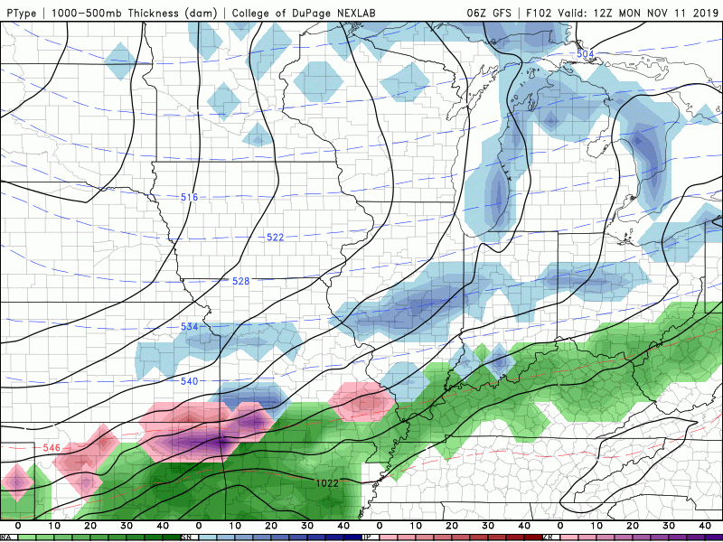 Stay dry this afternoon and don't forget your coats tomorrow morning as it'll be a chilly one. Have a good day! Good morning to everyone! It's another chilly start to the day but we will warm comfortably into the mid 60's this afternoon. If you are a fan of cold weather, we have a treat for you. This time next week an Arctic air mass will reside over the eastern US dropping temperatures into the 30's and 40's as high's here in east TN. Keep in mind cold air doesn't always mean snow, but there is a chance to see a snowflake or two early to mid next week. Be sure to check back in for the latest development of this next system. 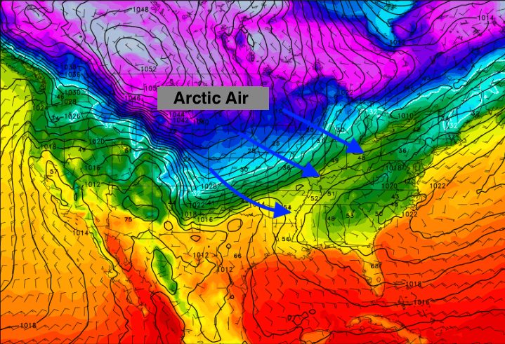 Jumping into tomorrow's outlook, a system to our west will move in. Steady light showers throughout much of the day tomorrow is expected before clearing out tomorrow night. A cold front will clear things out overnight tomorrow, allowing for a chilly close to the work week. Friday high's will be in the mid 40's with temperatures gradually warming as we get into the weekend.  Model guidance is picking up on scattered showers late tonight and early Thursday before the brunt of the rain arrives mid-morning. These showers will carry on throughout much of Thursday before pushing east (ahead of the cold front) by tomorrow night. Backing air from the north will keep things chilly and dry Friday and through the weekend.  Thats all we have for your Wednesday but enjoy the mild conditions Mother Nature is giving us today before rain and chilly temperatures return. Happy Tuesday all! It has been a pleasant start to the work week with high's in the 60's but unfortunately, changes are coming. Model guidance shows the possibility of a sprinkle or two this afternoon (in the higher elevations) but for the valley, expect to stay dry with clearing skies by this afternoon. Working into Wednesday, much of the same with mostly sunny skies and high's back in the 60's. Toward the end of the GIF below, you can see showers start to work in late tomorrow night and into early Thursday (from west to east). This is all apart of our next system that will arrive to close out the work week, bringing much cooler temperatures Friday and the weekend.  The broken cloud we had to start the day is associated with a weak front that has pushed east. The high following will keep things dry and comfortable Wednesday (as model guidance suggested) before a system arrives Thursday. With this next system, expect rain totals between 0.5 inches and 1 inch throughout east TN. Following the showers, a strong cold front will push through. As this cold front moves in, parts of the smokies could see a brief transition to some frozen precipitation overnight Thursday. We will stay with all rain here in the valley but temperatures into the 40's are expected as high's Friday.  Looking into next week, conditions do not look to improve (temperature-wise). With a 70%+ chance of below average temperatures, confidence is high we will stay well below the typical mean for this time of the year. Arctic air is expected to dip into much of the eastern half of the US bringing high's into the 30's for some and low's in the teens by mid-week next week. Be sure to check back in for the latest regarding this early season cold fluke we are anticipating next week. We could see some records being broken throughout the US this time next week. 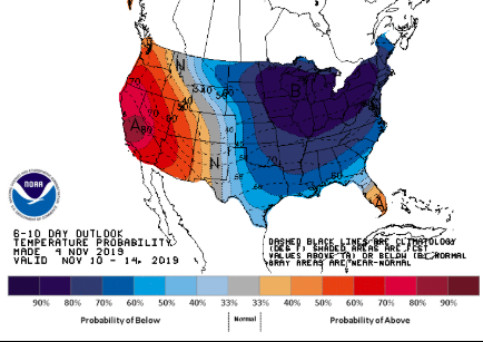 That will wrap up your Tuesday forecast! Share your great pictures on our social media by tagging us or emailing them to us. We had several great shots of the sunset last night sent in and we would love to post yours as well. Have a great day! We have a few clouds moving through the area ahead of a front to the west. Luckily, we will stay dry this afternoon and through mid week before our next system arrives. Along with the drier conditions, expect to gradually warm up as well. This afternoon we will top out near 60 degrees with high's by Wednesday in the mid 60's. 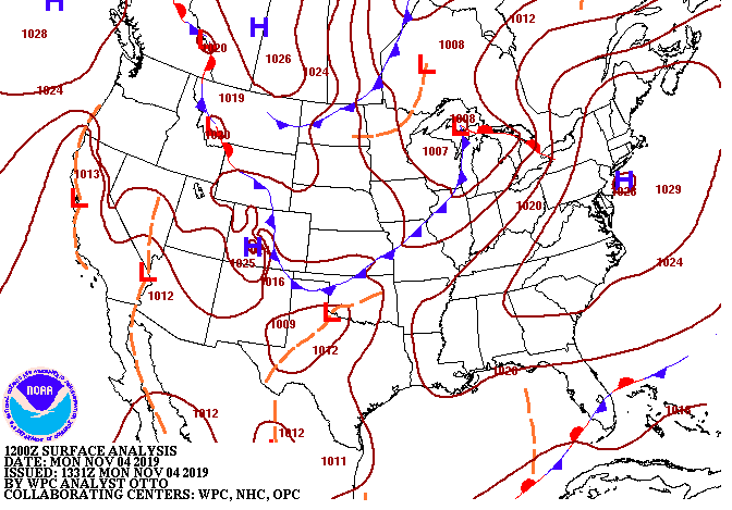 Model guidance shows the development of some light showers tomorrow afternoon in parts of west and middle Tennessee, but with a stable atmosphere overhead, we will stay dry here. A high pressure system will stick around through Wednesday before our next rain maker arrives Thursday. The latest data suggests around a quarter of an inch of rainfall Thursday into Friday morning before a cold front clears things out and cools things off.  In regard to that cold front, the surface map for Thursday (Below) shows the strong cold front working its way in from the north and west. Expectations for this system are very similar to last week. Light showers on and off through the day Thursday will lead to a sharp temperature change Friday with much colder temperatures entering the weekend. High's Friday will be in the 40's with overnight low's in the 20's. 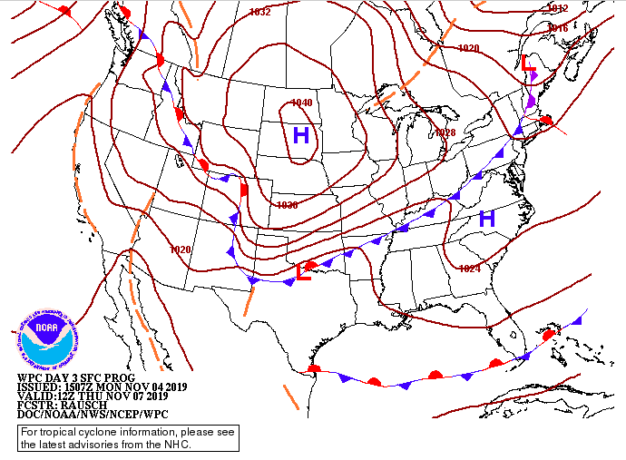 Be sure to enjoy the sunny skies and comfortable conditions the first half of this work week presents before showers and much cooler temperatures arrive the later half. |