|
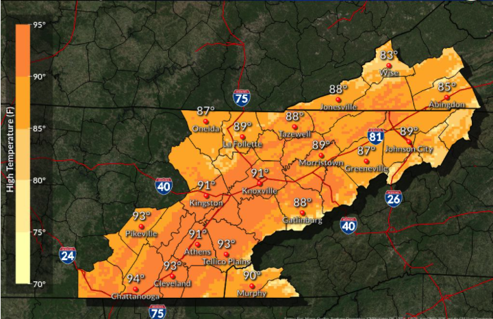
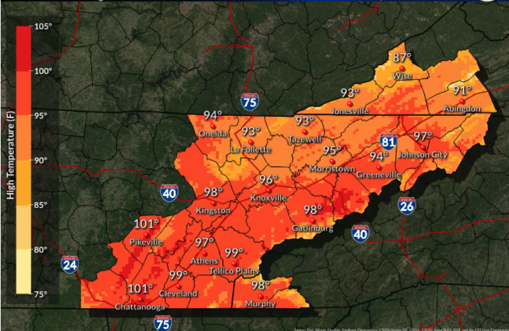
Good morning! Like a broken record, it will be another warm and mostly sunny day with highs in the upper 80s. As high pressure continues to settle in across the Tennessee Valley, we will remain warming and dry. There is some light at the end of the tunnel (if you are sick of the unseasonably warm temperatures and dry conditions), as rain chances move back in midweek next week.  Looking at the NWS official forecast (LEFT), highs through the weekend will range from the upper 80s to lower 90s. Looking at the image on the right, this is the WORST-CASE scenario. Because statistics plays a large role in weather forecasts, this image indicates the 90th percentile of values. Though we likely won't see mid to upper 90s, things will still be very warm for this time of the year. Be sure to throw on that sunscreen and drink lots of water if you're outside for lengthy amounts of time.
With high pressure in place, quiet weather remains for the time being. As the high breaks down and shifts south early next week, showers rounding the ridge will begin to work back in. A cold front extended down from Canada will also assist in bringing better shower chances Wednesday and Thursday, as well as cooler temperatures back down to near average. Until then, anticipate things to continue warming and staying dry.  That will conclude todays forecast, don't forget to share your images with us by sending them to [email protected] or tagging us on Twitter/Facebook. Have an excellent weekend, enjoy the sunshine, and stay cool! Pre-recorded for 5pm show
0 Comments
Leave a Reply. |