|
Happy Monday to all! It was a cold one this morning and continues to be this afternoon. Though we weren't expecting accumulations in the valley, we were in the higher elevations. Check out the latest view from the Newfound Gap area of the smokies. A few inches fell overnight and will continue to grow through this afternoon. 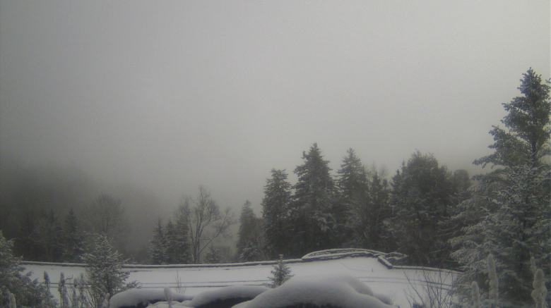 As for our surface map, the higher elevations to the east will continue to feel snowfall through the day and into the overnight hours tonight. A few remnant snow flurries can't be ruled out through the day here, but no accumulations are expected. High's today will be chilly, in the upper 30's, near 40 degrees. As we get into Tuesday, a high pressure system will begin working in clearing things up and increasing temperatures. 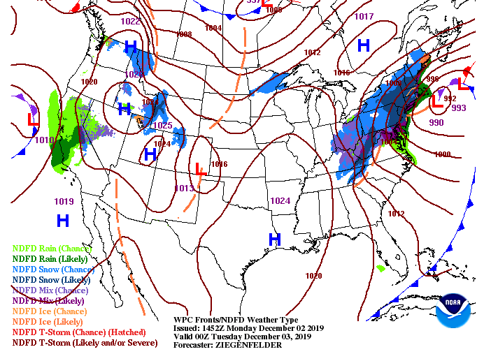 Model guidance is still suggesting remnant snow showers/flurries continuing into this afternoon and evening as this system continues to push eastward. Getting into Tuesday, clouds will begin thinning out allowing for pockets of sunshine throughout the day. Wednesday, sunny skies return along with temperatures back in the low 50's.  The "chill" will continue to stick around into Tuesday, so be sure to dress warm. Have a good start to the work week!
0 Comments
Check out this shot from the Stansfield's webcam in the Oak Ridge area. Things appear to be pretty calm but changes are quickly on the way this evening/overnight. If you recall the system that just passed through yesterday, we will be feeling another round of moisture from the north as moisture wraps around the surface low. With east TN being on the cold side of this storm, we have the chance to see snowfall overnight.  Looking at the current surface map below, the arrows show the movement of this wrap around moisture tonight. Think of this storm (if it were stationary) as spinning counterclockwise. Now, imagine this counterclockwise flow while move in an east/northeast direction. We are receiving the effects of this "wrap around". Precipitation from this system will end by early tomorrow afternoon leaving us cool and dry for first half of the week. Of course with frozen precipitation involved, we will be at or below freezing working into Monday. Expect much cooler temperatures to start the new work week with high's only in the upper 30's, around 40 degrees, here in the valley. 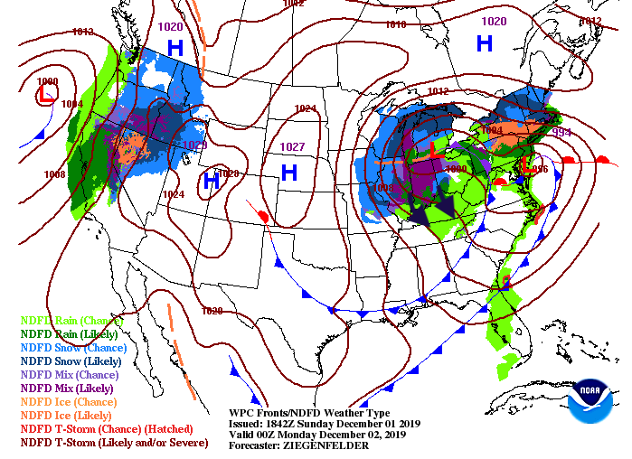 There are many advisories/watches/warnings out tonight and into Monday so be aware of the weather hazards. Specifically for the higher elevations there is a winter weather advisory for those in the Plateau, northern TN, and foothills of the Smokies. Working further to the east a winter storm WARNING is in effect with snow accumulations of 6+ inches likely in the highest peaks of the Smokies. This map also paints a good picture for snow accumulations overnight: Accumulations by area: The valley: nothing to up to a dusting The Plateau and northern TN: up to half an inch The foothills of the Smokies (east of the valley): 1-2" The Smokies: 3-6" with the higher peaks getting up to 10" 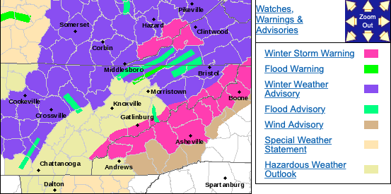 Here is the latest from model guidance below. Showers will begin moving in (from the north) around midnight and begin transitioning to frozen precipitation early Monday morning. With warmer air trapped in the valleys, snowfall will be limited. As you get into the Plateau and Smokies, snowfall increases with cooler temperatures in the higher elevations. For the majority of us overnight, temperatures will near freezing leaving a majority of rain here in the valley and a few flakes on the tail-end. This all depends on when the cold air arrives from the north. Nonetheless, for those in higher areas of the valley, and those outside of the valley, be cautious of slick spots in the morning hours. The Great Smoky Mountains National Park Service has already closed numerous roads ahead of the heavy snowfall expected overnight and into Monday.  Continue staying up to date with us overnight and use caution in the morning hours, as snowfall is expected for most outside of the valley.
|