|
Happy Friday to everyone! As we continue to be held in this holding pattern, we will stay mostly sunny today and the next several days. This will make for a great weekend to "chill out" on the lake. High's will be in the mid to upper 80's under mostly sunny skies. 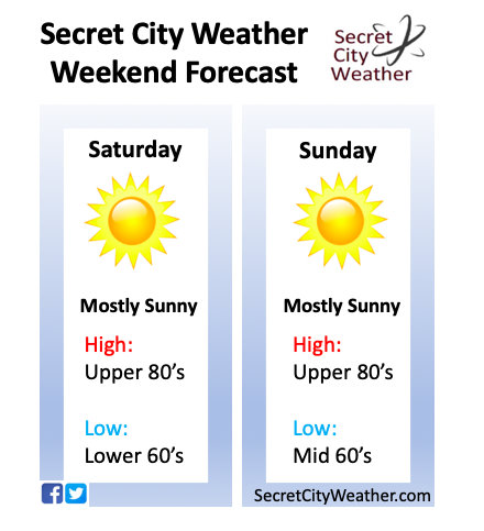 Taking a look longer term, we see a cold front to our north, which will slide through tonight. This will bring us similar temperatures as today, with high's expected to be in the mid to upper 80's Saturday. As we push into the later part of your Sunday, though, a high pressure system will move in bringing much warmer temperatures to start your work week next week. High's are expected to be in the low to mid 90's both Monday and Tuesday, as well as "feel-like" temperatures near the triple digit mark.  The latest model guidance is suggesting an isolated shower or two overnight, but overall I am not expecting much (if any) as the atmosphere is pretty dry. These showers, though, are associated with a low pressure system moving through the great lake region, and this is what will bring us the cold front overnight. For your weekend and early next week, we will stay mostly sunny with increasing temperatures each day.  I hope everyone has a good rest of their Friday and a great weekend! Remember, we would love to see your pictures out on the lake, hikes, etc. You can share them by emailing them to us at [email protected] or by tagging us on Twitter or Facebook @SecretCityWX.
0 Comments
Leave a Reply. |