|
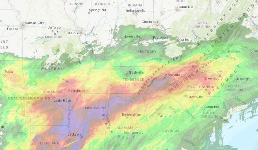
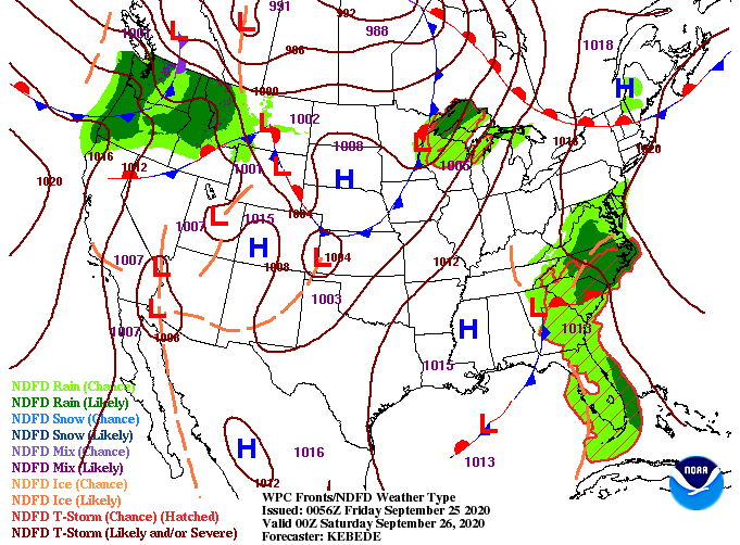
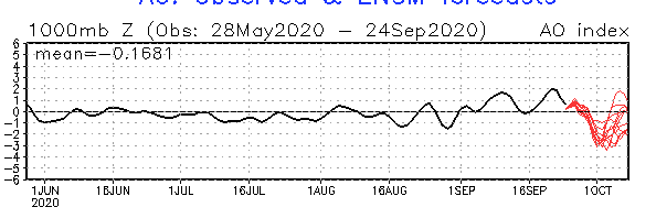
Rainfall is beginning to peter out this morning as remnants of Beta continue to work eastward. The latest 24-hour precipitation accumulation map shows totals near the 4 inch mark for parts of McMinn to the south of Knoxville. The remainder of the area is lying in the 2 to 2.5 inch mark from Chattanooga to Jefferson City. All in all, movement of the system did work a bit further east with the later models we saw yesterday. Flooding conditions stayed limited as of this morning but if you have a report, you may send it to [email protected] or by tagging us on social media. Looking at the latest surface map, the low associated with Beta is working east, leaving a bit of drier air in behind. Unfortunately, this won't stick around too long as another system to the north and west will swoop through. This will allow for scattered showers the second half of the weekend and into early next week. Following the system, a steep cold front will leave high's Wednesday and onward in the lower 70's to mid/upper 60's. Doing a little teleconnection analysis, the Arctic Oscillation is phasing towards a negative signature....so what does that mean? As a brief background, teleconnections are large scale "signals" based on pressure and circulation differences. In this case, a -AO indicates the likelihood for cooler air across the southeast and and weaker trade winds off the coast of Africa. This relationship can be seen as we work into the next 3-8 days. Activity in the Tropics (as of this morning) have all but ceased and cooler temperatures are expected to migrate in the second half of next week. As shown from the graph below, AO will shift back positive, but it will be nice to feel a Fall front and have little activity in the Atlantic. I would also like to mention teleconnections are not see all be all, they are only guidance to help in a longer term forecast. As showers work out this morning, drier air will move in tonight. For the most part, expect showers to be out of the Valley by 2pm this afternoon. Most of us will stay dry tonight and through Saturday before scattered showers return Sunday and Monday with the next system. Once the cold front moves through, Wednesday, sunny skies will remain as cool dry air dominates behind the front. With lots on the plate today, check out all the details through the video forecast below. If Secret City Weather can help you, be sure to shoot us an email or visit our "Services" tab above. Have a wonderful weekend and check in on Twitter/Facebook for updates throughout the next couple of days.
1 Comment
9/27/2020 05:30:18
It will always be a great pleasure for us to know the right answer to the questions to our mind. I want to know the right answer in my questions. It will be a great help for us to know more about the details of this post. Informative post will give us the clarity that we want to have. Let us read more and never stop reading for this will save us in the future. It will be a great opportunity for us to grab. It will make a great impact and for that we will be grateful for it. I want to be the hero in my generation by sharing the wonderful facts that I have read.
Reply
Leave a Reply. |
Your trusted source for everything weather in East Tennessee.
Social Media
|


