|
Another Spring-like day is on tap, with highs today in the upper 60s and low 70s. Check out the forecast as we work into the weekend though. Highs Sunday can be seen below, but Saturday won't be too far from these values either. Keep in mind, the record high in Knoxville (as it stands now) on Sunday is 79 degrees. 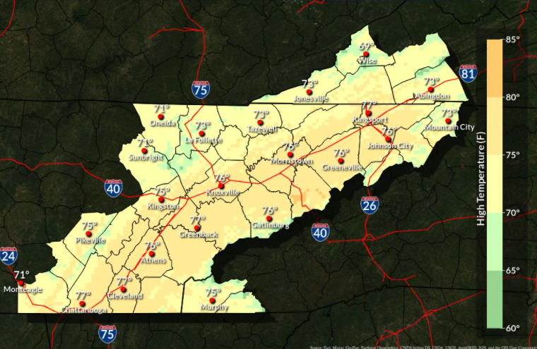 As we move forward, a wavering frontal boundary will bring several things. First, slightly cooler air for Friday. By cooler, you can anticipate highs Friday to remain in the upper 60s to low 70s. As an area of low pressure develops along it, this boundary will build north in the form of a warm front (Saturday and Sunday). As it does so, warm moisture rich air will filter in. This will increase cloud cover and lead to isolated showers at times late Saturday and again at times Sunday. By Monday, a cold front will begin inching in from the west and bring the opportunity for widespread showers and possibly a thunderstorm. Cooler and drier air will then follow for Tuesday.  After a dry and warm week, a transition back to an active pattern is set. The rainfall outlook over the next week suggests upwards of an inch across East Tennessee, but much higher amounts to our north and west. 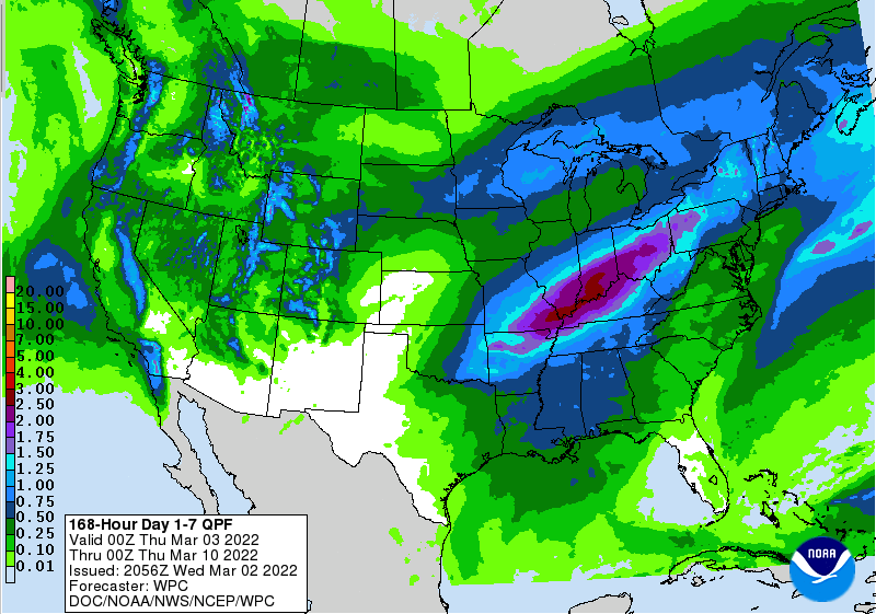 Another pleasant, warm, and sunny day is set so take advantage if you can! Don't forget to watch our video forecast below as well as follow us on Twitter & Facebook (@SecretCityWx) Pre-recorded for 5pm show
0 Comments
Another warm start to East Tennessee and that will continue now and through the weekend. High pressure will continue to shift east providing warm air to the area. A diminishing and dry cold front looks to cross Thursday night, which could stall highs Friday afternoon, otherwise expect an on-going upward trend through Sunday. 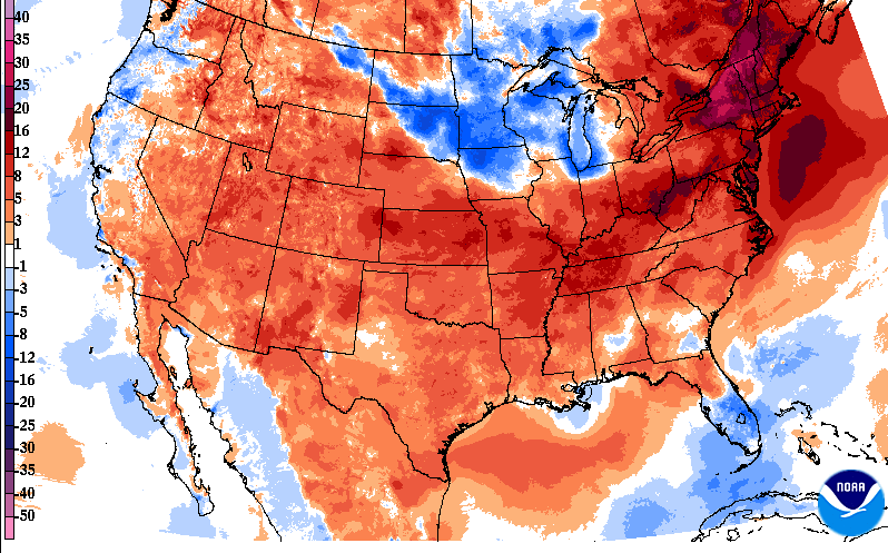 Keeping highs in mind, let's further look at records. Our best potential will be Sunday afternoon, as the record in Knoxville currently sits at 79 degrees. If we get enough sunshine during the morning, along with the strong southerly surge, we could see this happen. Nonetheless, it puts in mind how warm things are when comparing to records for the day. Longer range, a cold front will bring better rainfall Monday, cooling things down Tuesday, and making a return for highs in the 50s. 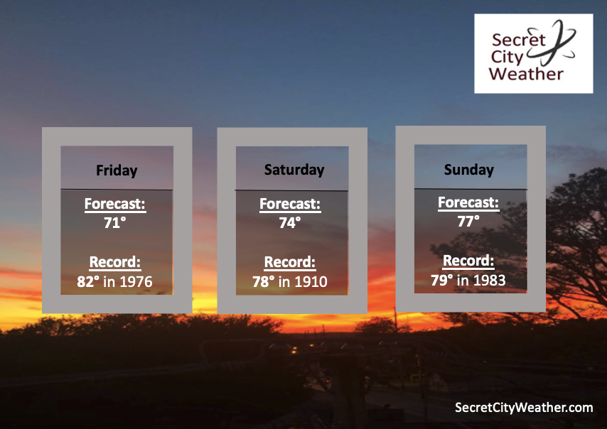 Take advantage of the warmth and sunshine today and tomorrow with highs in the upper 60s and low 70s. Cloud cover will increase through Friday and Saturday leading to a few showers by the end of the weekend, with widespread activity by Monday. Pre-recorded for 5pm show
Good morning and happy March! Appropriately, it will feel very Spring-like today and the remainder of the week as a whole. Looking at the past 24-hours, we are already warmer than we were this time yesterday and afternoon highs will definitely reflect that as well. Most should find themselves in the low to mid 60s, with a few pushing near 70 degrees. 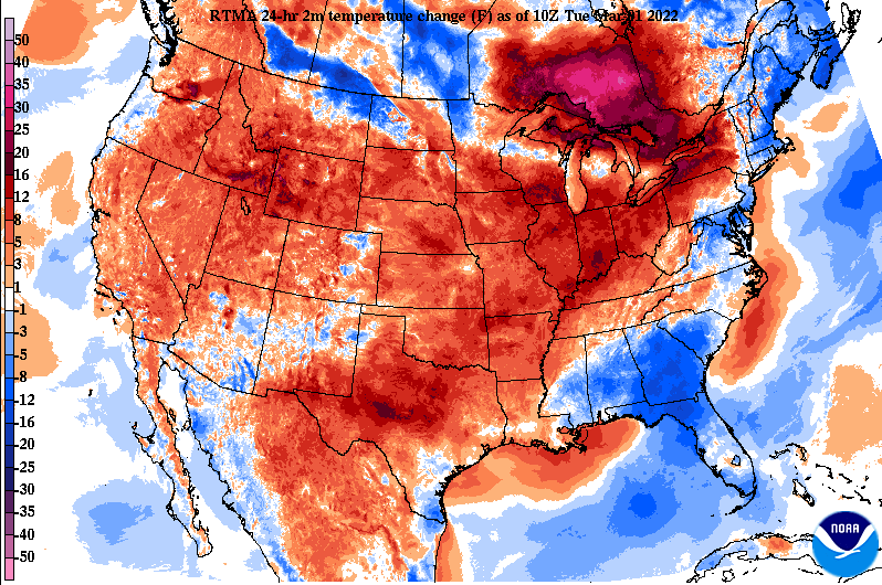 Why is it so warm right now you may ask? A stout area of high pressure is planted across the Southeast. This is allowing for warmer air to pump in from the southwest, increasing temperatures well above the norm. An increase in temperatures is expected nearly every day from now and through Saturday.  How warm will things get? Looking at the temperature anomalies (which compares expected temps from the norm), highs Saturday will be 15 to 20 degrees above the norm. For those living further norther and west (W KY, Indiana, Illinois, Missouri) 25 to 30 degrees above the average is expected. This is all to say: it's going to be warm! Our best opportunity for record breaking heat (through Saturday) looks to be Thursday with the current record in Knoxville at 76, but this could be tough to achieve.  Other than the increasing temperatures and winds out of the southwest, weather conditions will remain fair the next couple of days. Our next best chance of rain doesn't arrive until Saturday, with showers expected by the evening coming in from our northwest. Pre-recorded for 5pm show
|