|
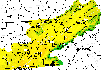
I hope you are staying cool on this Tuesday! Temperatures as of 11:15 this morning are already in the low to mid 80's. The cloud cover to the north and west is associated with a slow moving front. Moisture will begin streaming in tomorrow along this front, allowing for better shower chances Wednesday and Thursday. As for today, shower activity will remain limited. The bulk of activity will stay in the higher elevations. The main focus remains on the very warm temperatures. Afternoon heat indices today will top out, again, in the triple digits. High's alone will be in the mid to upper 90's. We will see a slight break in temps the next couple of days, but don't get too excited, we'll still be in the lower 90's. As seen from model guidance, the NAM continues to suggest better shower chances Wednesday and Thursday. As the front moves eastward, moisture from the Gulf will funnel through the area providing scattered showers and storms. By Friday, a high pressure system will arrive, clearing things out (for the most part) for the weekend. A Marginal risk is in place again today and for Wednesday, so be weary of strong storms producing gusty winds, hail, and frequent lightning. Thank you for viewing our content today and everyday! Stay cool as feel-like temps will find their way back into the triple digits this afternoon.
1 Comment
7/22/2020 00:01:06
Weather changes every now and then. But because of climate change, our weather changes abnormally. We all know that human is the reason of Earth's climate change. While we still can, we must work together to reverse the effect of Climate change and global warming. If we don't act fast, we might all suffer the consequence of our abuse on our planet. There are a lot of ways to help our planet recover, we just need the initiative to do so.
Reply
Leave a Reply. |
Your trusted source for everything weather in East Tennessee.
Social Media
|


