|
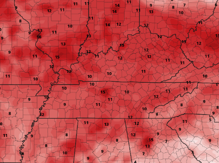
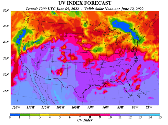
Good Friday morning to you! Present temperatures (8 am) are in the upper 50s to mid 60s, with cloud cover quickly increasing. We wanted to start off highlighting the biggest threat over the next week and that'll be the temperatures. Taking a look below, values indicate how much warmer temperatures could be compared to the average. That means some areas could be anywhere between 10 and 15 degrees + above average through the first half of next week. In addition to temperatures, humidity values will also be high. This means heat indices of over 100 can be expected. Keep your heat safety in mind as the warmest temperatures so far this year will find us Monday-Wednesday. Falling in line with the Summer-like conditions, the UV index is forecasted to be very high as well (10-11). If you plan to be outdoors for extended periods of time, keep the sunscreen, water, and shade close by! Jumping back into the shorter term, an upper level disturbance will bring isolated to scattered showers & storms later this afternoon and into the night. This should pass fairly quickly, as drier conditions make a return Saturday afternoon/evening. High pressure then fills in Sunday, bringing the aforementioned heat and humidity Sunday and early next week. Lastly, the latest drought map has been released. Given the widespread rainfall we saw last week, there has been many improvements. We will see if this takes a hit over the next week or two, as drier than normal conditions are in the plans. Temperatures today and tomorrow will be near average (upper 70s to low 80s), before warming to the upper 80s Sunday and low to upper 90s early to mid week. Check out our video forecast below for more. Pre-recorded for 5pm show
0 Comments
Leave a Reply. |
Your trusted source for everything weather in East Tennessee.
Social Media
|


