|
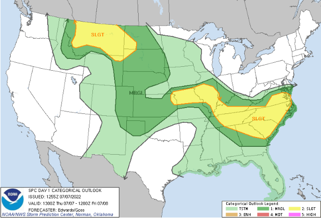
Jumping right into it, the lack of rainfall across portions of the state have really taken a toll. Looking at the latest state drought map, southwestern TN is now in a severe drought, while the remainder of the west is in a moderate drought. This is all while East Tennessee sees mainly normal to abnormally dry conditions. Even so, there is a few pockets of moderate drought, where showers and storms have been lacking. Thankfully, a sweeping cold front will bring widespread rainfall late Friday and into Saturday, but this may not be enough for West TN to catch up. It is important to also note, the bulk of the rainfall over the next 7 days will be across the Plateau and east. This is something we will continue to watch, as this plays a big role in agriculture, fire hazards, and more. Swinging back into things for today, a slight risk of severe storms encompasses a large part of the state. We have already seen scattered showers and a few rumbles of thunder this morning, but this will again pick back up into this afternoon and early evening. Some activity could be strong to severe, with isolated instances of flash flooding as well. Stay alert and know what to do if a warning is issued for your area. In addition to the showers & storms today, a cold front will push southeast through the day tomorrow, bringing better rainfall chances late Friday and into the early weekend. Again, some of these could contain stronger storms within, but the chances of severe weather are generally lower given the timing. With that said, isolated flash flooding remains possible, especially for areas that have seen repeated rainfall so far this week. By Sunday afternoon, showers should be exiting the area, providing a much needed relief from the heat and humidity. This will carry into portions of Monday as well, before things return to the warm and muggy conditions we have been experiencing. Pre-recorded for 5pm show
0 Comments
Leave a Reply. |
Your trusted source for everything weather in East Tennessee.
Social Media
|


