|
As a low pressure system continues to settle overhead, lots of rainfall will funnel into western North Carolina today and tomorrow. The Weather Prediction Center (WPC) has labeled this area of NC under a HIGH risk (4/4) of flash flooding through today. A slight risk is highlighted for parts of Kingsport, Bristol, and Johnson City today as well. Though flooding potential will begin winding down the next few days, a marginal risk is still in place for those in flood prone areas, especially near water features. 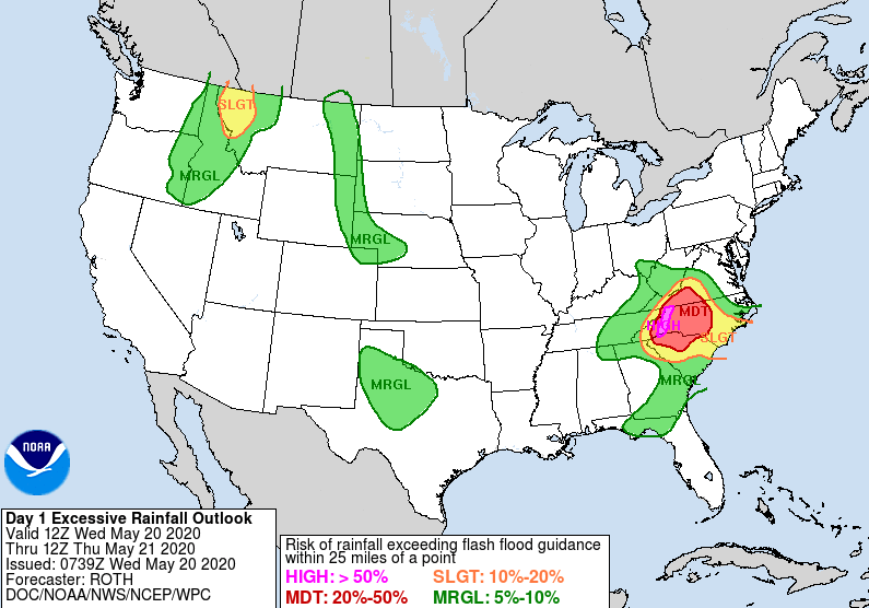 For the days to come, cloudy skies and scattered showers will continue. The bulk of this, as seen from the excessive rainfall outlook, will be to the east now through Friday. For the central valley, we will continue to see a few scattered showers/ rumbles of thunder the next few days with lesser chances as you move west. The good news is this system will begin working NE tomorrow and Friday allowing for some sunshine to return for Memorial Day weekend. Isolated to scattered showers remain in the forecast but activity will be limited through the weekend. Saturday and Sunday will mainly contain your typical afternoon showers/ t'storms we are accustom to during the summer. These will likely form off of the Plateau & Smokies and roll into parts of the valley during the afternoon hours.  The latest run for rainfall now through Friday really illustrates where the bulk of rainfall will be. An additional 1-3" will fall for NE TN with lesser totals as you push west. I expect us to round out the work week with 2-3" total for the central valley. We have already picked up, as of this morning, just over an inch and a half. 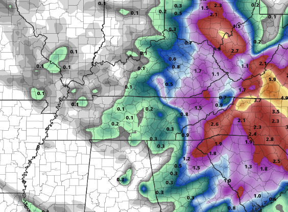 A few more gloomy days are ahead before better chances at sunshine present itself into the weekend. If you'd like more information into weather conditions for personal use or for your business, send us an email at [email protected] or visit our services tab at the top of the page.
0 Comments
Leave a Reply. |