|
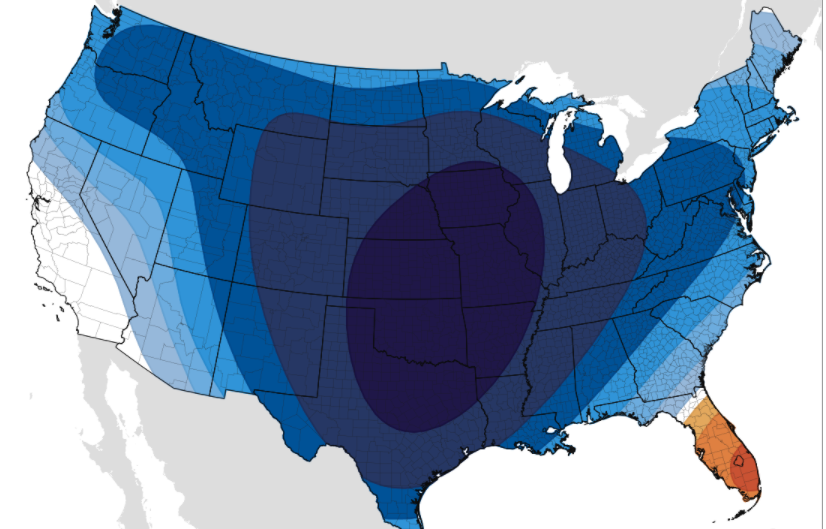
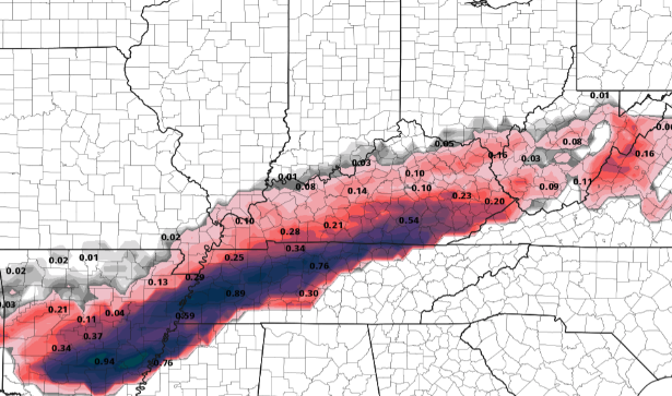
Happy Hump-Day! Cloud cover continues to hang above with the sight of showers in the not too distant future. In fact, radar has activity to our west, in TN, and to our north in Kentucky. These will continue gliding eastward, arriving by the later part of the afternoon and into the overnight hours. Switching subjects a bit, cold air looks to finally intrude the state. After about a week's bout, things are looking up for you cold lovers mid-February. As an Arctic air mass dips south, we'll see cold air influencing East Tennessee early weekend with high's by Sunday in the 30's for most. A little hint ahead, we could see some winter weather early to mid next week. The latest trends look to bring the chance for an icing to snow event, so something to definitely tune back in for as we gather more details in the coming days. For now, hold tight, stay dry, and warm as we get into the weekend. Running through the sequence for today and tomorrow, a system from the southwest will push east today. A few sprinkles to light showers ahead of the main system will be possible today, otherwise we will stay cloudy. By this evening, initial moisture will nose in followed by heavier showers (at times) overnight. We could see the potential for some thunder tonight as well, but no severe weather is expected. Showers should continue through the bulk of Thursday (in a west to east orientation) before drying out Friday. As it stands now, East Tennessee will fair on the "good side" of things. Precipitation in the form of all rain is expected for this event. Unfortunately, our friends just to the west and north aren't so lucky. With cold air at the surface and warm air aloft (in the atmosphere), freezing rain is the likely setup for the areas shaded below. Significant icing is possible Wednesday night through Thursday with totals in the 0.25" to 0.5" ballpark (& locally higher). If possible, avoid travel in these locations on Thursday as power outages, icy roads, and downed trees are all a likely possibility. Nearly all of Kentucky is under an Ice Storm Warning. Trends continue to push this line further south, so fingers crossed we hold on to enough warm air all the way down to the surface. We'll continue to monitor this very closely and give you any updates we may have. Anticipate, for now, an all rain event with freezing rain a concern for far western-East Tennessee. Rain totals will be upwards of an inch through Thursday will locally higher amounts possible in heavy downpours and thunderstorms. Have a good one, be safe, and continue to check in via Twitter & Facebook for any changes we may have with the forecast. Pre-recorded for 5pm show
0 Comments
Leave a Reply. |
Your trusted source for everything weather in East Tennessee.
Social Media
|


