|
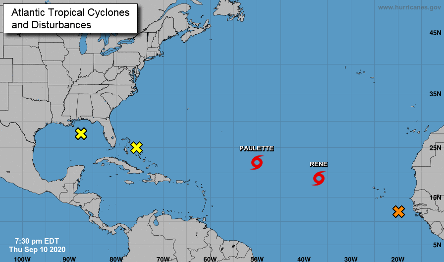
Improvement continues across the state with only southeastern TN seeing abnormally dry conditions. With rainfall in the forecast this weekend, most of this area should return to near normal conditions. As for weather conditions today, they'll be very similar to yesterday. A mix of sunshine and cloud cover with a few showers developing in the afternoon (mainly higher elevations). High's top back out near 90 degrees with feel-like temperatures in the mid 90's. With September being peak hurricane season, we can verify the truthfulness with FIVE potential systems in the Atlantic. Two, of course, have developed into tropical storms (Paulette & Rene) but pose no threat for landfall. Far eastward, a wave off the coast of Africa will likely intensify through the weekend. The path and movement are much too early to tell but this will be something to watch for as we progress into next week. Closer to home, one system in particular is worth noting. A disturbance near the Bahamas (right of Florida) is expected to work westward crossing over the Caribbean and parts of Florida. By early next week, this will land in the Gulf where intensification could take place. The NHC believes the environment in the Gulf will be conducive for growth and a Tropical Depression can't be ruled out. We'll provide updates when needed! With a front still hanging to the north today, the bulk of activity will be north and west of the area. As we work into Saturday, this will work south providing better coverage (especially the second half of the day). Showers and a few embedded storms are likely throughout Sunday before becoming more scattered by early next week. Rainfall amounts vary throughout with the highest rainfall in the plateau. It is worth highlighting the WPC has labeled the eastern half of Tennessee under a marginal risk for flash flooding both Saturday and Sunday. Those of you in flood prone areas should use caution throughout the weekend. For the work week next week, scattered showers are possible each day with high's in the lower 80's. Unfortunately, long term guidance hints back toward a warming trend for mid-September. For now I wish everyone a good and safe weekend. Do your best to stay dry as we'll more than likely see rainfall Saturday and Sunday.
0 Comments
Leave a Reply. |
Your trusted source for everything weather in East Tennessee.
Social Media
|


