|
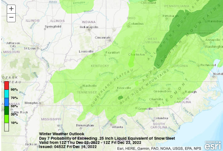
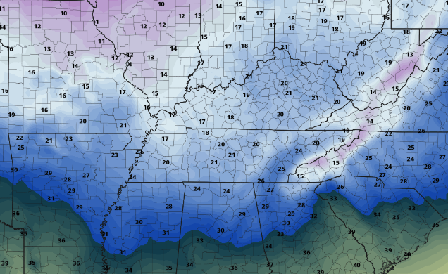
Lots to discuss today, so we will jump right into it. First up, check out the latest drought map! Huge improvement since last week and especially the most recent weeks, as half of the state has returned to normal conditions. After our bout of rainfall the past few days, I expect continued improvement for for all this time next week. Speaking of next week, what changes we have in store! Starting first with what you can expect this weekend and into early next week: generally very little. Most should anticipate a mix of sunshine and passing clouds with highs in the low to mid 40s each day. We will be wedged between high pressure near to just to our south and a disturbance to our north. Because of this, can't entirely rule out a light snow shower or set of flurries in the highest elevations of the Smokies tonight through Saturday night. Otherwise, dry and cool conditions prevail for the vast majority of us. Now, into the changes later next week. As many of you have probably seen, heard, or even wished for, we have the chance for a wintry system to pass through the area. The details, as of now, remain some what fuzzy, but chances are likely we see precipitation of some kind. The latest guidance depicts a strong area of low pressure and an Arctic cold front sliding through the region, bringing a rain to snow mix followed by very cold temperatures. Looking below, this outlook depicts the chance we see at least 0.25" of snow/sleet liquid equivalent. This means if you were to melt the snow/sleet down, this is the probability that it would equate to at least a quarter of an inch. For common figures, we use a 10:1 ratio for snow. This means 1 inch of rain roughly equates to 10 inches of snow. So, you could think of this as the probability of at least 2 inches of snow (with lesser amounts if talking sleet ratios). Keep in mind snow ratios vary greatly based on temperatures, but this is the general rule of thumb. As such, we do see a low end chance of solid accumulation later next week (Thursday). With timing, strength, and low pressure path still uncertain, changes are likely, but the overall set up of precipitation (of some kind) and cold temperatures is a near lock. So, touching on the cold temps, take a look at this raw single model output for potential highs Friday (the 23rd). Yes, these won't be the exact readings but it gives you an idea of the kind of cold we are talking about. Low temperatures into Friday and Saturday morning (depending on snow potential) could be in the single digits to the teens. To make it worse, afternoon highs will likely not cross the 30 mark, with most more than likely in the low to mid 20s Friday and Christmas Eve. Another element to keep in mind are wind gusts. The strong front will bring breezy conditions to the area, which could lead to dangerously cold wind chills. I will emphasize changes are likely and there is still a lot of details to pan through in total, but brace for some cold about 7 days from now. Though we are cooler than average today (highs in the mid 40s) and through the weekend, much cooler air finds us later next week. Start preparing now for the cold temperatures (proper car care, sheltering of outdoor animals, etc.) as well as the possibility of some wintry mix. As of now, confidence is low to medium on accumulating snow (at least for valley locations) and high for cold temperatures thereafter. Stay abreast to the latest updates, as we will have plenty more to come on Monday. Don't forget to also give us a follow on Twitter & Facebook as several updates, images, discussions are posted daily. Have a great weekend and we'll catch you back here on Monday! Pre-recorded for 5pm weather broadcast
0 Comments
Leave a Reply. |
Your trusted source for everything weather in East Tennessee.
Social Media
|


