|
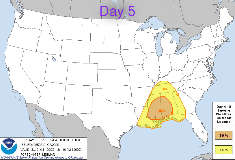
We have cleared up nicely after nearly half an inch of rain (here at the office) fell this morning. Looking into the next couple of days, ridging will dominate much of the east coast, leaving us dry and above average. As we work into Friday and this weekend, a strong system from the south and west will work in, leaving severe weather in question. Day 5 from the SPC (Storm Prediction Center) shows a 15% chance of severe potential for middle and west TN. From the latest data, storms will arrive in the afternoon and evening hours. Though the SPC gives middle and western TN the best chance for severe weather (Tennessee-wise), I believe severe potential still remains possible for our neck of the woods as well. Inevitably, the timing of initiation and the parameters that make up severe storms will play a roll in the severity here at home. Nonetheless, strong to severe storms (damaging winds & isolated spin-up), heavy rains (1"-3"), and flooding/flash flooding are all possible this weekend. For the time being, we will stay dry with ridging over the eastern USA but showers begin working in Friday. For Saturday, darker shades of yellow, orange, and even reds indicate strong showers and storms throughout Tennessee. As we get closer to time we will have a better idea of the severity and timing, but for now, enjoy the sunny and mild conditions we have the next few days. With stronger storms moving in this weekend, be sure to check back in for the latest in regard to this system. As we work into Saturday, not only is severe potential on our radar but also the opportunity to beat another high temperature record. The current forecast suggests a high around 70 degrees with the record being 72 (set back in 1890).
0 Comments
Leave a Reply. |
Your trusted source for everything weather in East Tennessee.
Social Media
|


