|
A chilly afternoon, but things are going to get even cooler for Tuesday. Taking a look first at tonight, a Freeze Warning will be going into effect. This will likely end the growing season for good, but for those with outdoor plants, be sure to insulate them to protect from the freezing temperatures we are expecting. Overnight lows will be in the upper 20s to around 30, with mid to upper 20s expected Tuesday night and into early Wednesday morning.  With the passage of the cold front late yesterday, temperatures are going to be cold for this time of the year. In fact, looking at what is anticipated versus the norm, we will be 20+ degrees cooler than average tomorrow and Wednesday. Most will likely struggle to break the 50 degree mark tomorrow, with most topping out in the upper 40s. Thankfully, sunny skies will prevail all week, as high pressure slowly works its way in and eastward. Additionally, Tuesday will be the coolest day, where temperatures gradually tick upward thereafter. 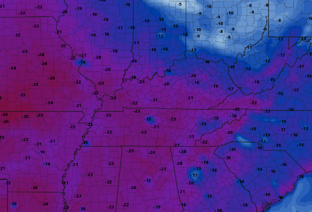 Longer term outlooks indicate an airmass change. From the chilly temperatures expected early this week to above normal temperatures late in the month (next week). To go with this, below average rainfall is expected during this time. With that said, early November data does suggest the opportunity for better rainfall potential, so fingers crossed as we remain below average for the month of October so far. 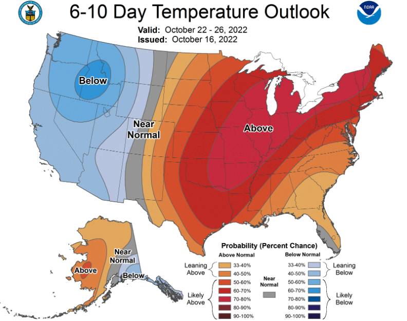 That will do it for today, the big news is the cold temperatures Tuesday and Wednesday with highs in the 40s and 50s. Overnight lows will be in the 20s to around 30 through Wednesday night, before more reasonable temperatures find us the second half of the work week. Check out our video forecast below for more. Pre-recorded for 5pm weather broadcast
0 Comments
Quiet but breezy into Saturday, with temperatures warming from the low 70s today to the mid and upper 70s tomorrow. A passing cold front then brings isolated to scattered (30-40%) showers Saturday night into Sunday. High pressure dries things back out late in the day, with sunshine following through mid week. This will come with the coldest airmass we have seen since Spring, where highs in the 50s find us Tuesday and Wednesday. Check out our video forecast below for more information. Good morning! Most are under cloudy skies as a cold front is making its way eastward. Fortunately, clearing is soon on the way, with sunny skies already across Nashville and portions of the Plateau. This will continue eastward through the morning, where sunshine returns for all this afternoon. Highs will be a bit cooler, nearing 70 degrees. 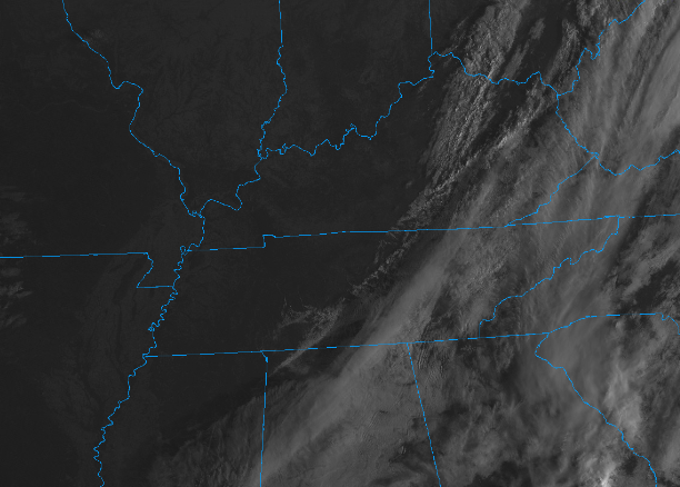 Looking at the 24 hour temperature change map, you can clearly see the cold front making its way through the Ohio Valley and down through the Lower Mississippi Valley. A change of 10+ degrees is seen, which will be most noticed overnight tonight with lows in the 40s. 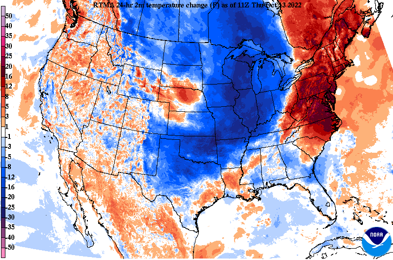 With the last of the showers (mainly far east) exiting, clear skies will return under passing high pressure. This won't last too long though, as another disturbance pushes in Saturday night and into the day Sunday. Showers will be scattered overall during this time, so some may not see rain at all. Dry air then returns by Monday with high pressure filling back in. Showers will be ahead of another advancing cold front, where MUCH cooler air arrives into early and mid week.  Check out early guidance attempts to predict Tuesday night/Wednesday morning temperatures. Assuming this pans out, and confidence continues to grow, we could be in for the coldest morning since late Spring. Lows for elevated locations could see the low 20s, while the valley lands in the upper 20s to low 30s. Bottomline, it looks to be a chilly one towards mid week, with highs in the 50s and lows well below average to match. 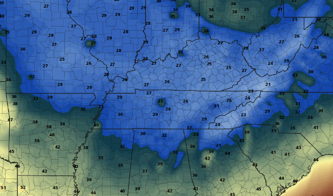 Skies will continue to clear late this morning, allowing for a beautiful and mild afternoon. Will highlight breezy western winds, where gusts up to 20 mph are possible. Have a great day, and tune back in tomorrow for the latest East Tennessee weather forecast!
Good morning! Rainfall has finally returned to the area, as indicated from this 10 am radar scan. These are scattered this morning, but will become widespread ahead of an advancing cold front later this afternoon and overnight. As far as temperatures, we will be mild again today, with highs topping out in the mid 70s. Additionally, it will be breezy at times, with southwest winds between 5 and 15 mph and gusts up to 25. 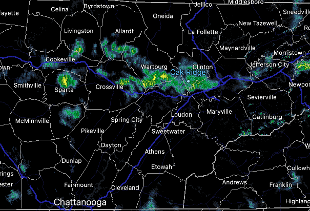 Breaking down the approaching cold front, scattered showers and storms will be possible through this afternoon. A few could be strong to marginally severe, though the chances are low given the lack of usable energy. Nonetheless, know what to do if a storm were to develop and become strong. The biggest threat will be damaging wind gusts, but isolated instances of hail and a brief tornado can't be ruled out. Into Friday, we cool and dry back out, before a secondary boundary glides through late weekend. This will bring another round of showers and maybe even a storm before a cold shot of air arrives early next week. We could even have some lows (in the valley) in the low 30s next week.  Given we have averaged pretty much zero in the rain column in the past couple of weeks, this is a welcomed site. Rainfall amounts today will vary between 0.25 and 0.75". Sunday amounts are lesser, but still something we won't complain about. Rain is essential this time of the year because it helps mitigate the threat of wildfires. Conditions both at the surface and aloft become more prone to wildfires, so it's important to stay near or above the average rainfall threshold (something we have not been doing as of late). 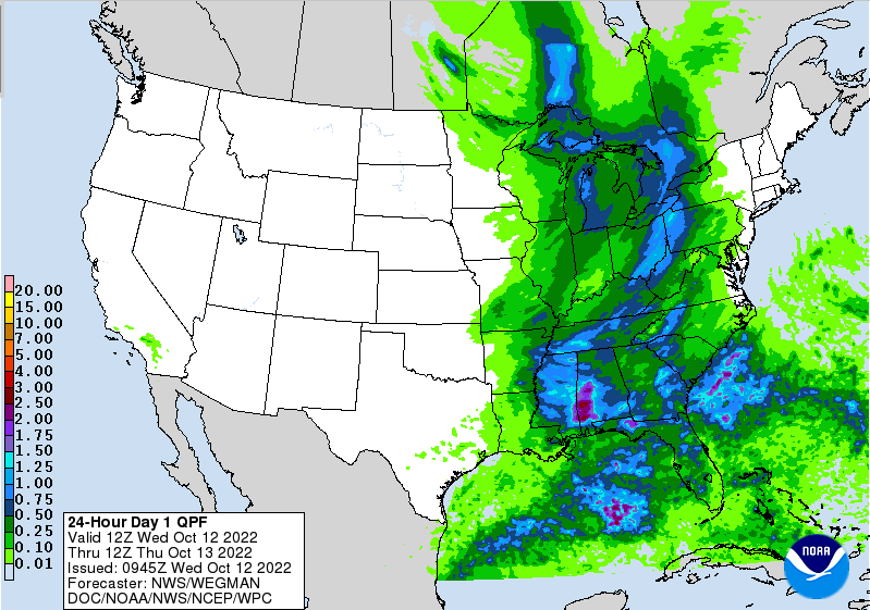 That will do it for today, remain weather aware. The threat is low for severe weather, but a few stronger storms can't be ruled out. Cooler air finds us Friday and the early weekend, before another front brings some rainfall Sunday into Monday, followed by another chilly airmass. Pre-recorded for 5pm weather broadcasting
Quiet and warming today, with increasing cloud cover this afternoon and night. An approaching cold front brings much needed rainfall tomorrow night and into early Thursday, followed by cooler air. A low end severe threat will be possible, where damaging wind gusts are the main threat. Timing looks to be after midnight Wednesday for the best potential of strong storms. Check out our video forecast below: Pre-recorded for 5pm weather broadcast
I hope you are enjoying Columbus Day thus far! Though it may not feel like it, we are starting out warmer than this time yesterday. Highs will find the upper 60s and low 70s this afternoon, warming to the mid 70s tomorrow. 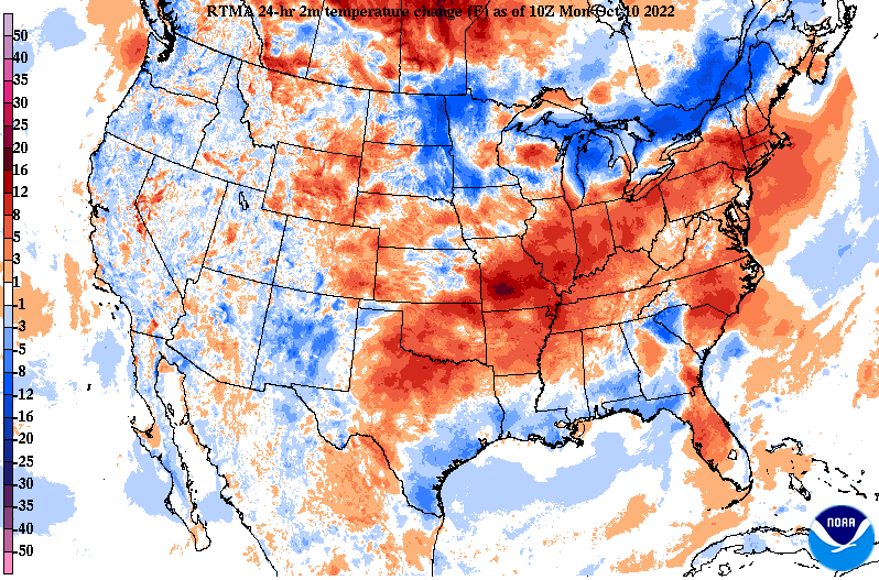 Moving forward, a potent cold front is in route, bringing MUCH needed rainfall to East Tennessee. Looking at guidance below, the best rain chances will arrive into Thursday morning, but a few isolated showers can't be ruled out late Wednesday. Totals aren't overly impressive, but we will take what we can get. For now, anywhere between 0.25 and 0.5" is expected with locally higher amounts possible in thunderstorms. Dry and cool conditions then return Friday and into the weekend with highs falling back in the 60s.  Along the front there is a low end chance for severe weather. A Marginal (1/5) risk is in place Wednesday night into Thursday morning, with damaging wind gusts the primary threat. We will have to keep an eye on the evolution of this system, as guidance is hinting at the better potential much further north.  Continue to check back in with this system, as some changes are likely. The good news: rain returns! Enjoy a beautiful day across the Volunteer State, with even warmer temperatures in tomorrow. Pre-recorded for 5pm weather broadcast
Good morning! A mild start for most in the mid 40s to low 50s. By this afternoon we'll find highs in the low to mid 70s under mostly sunny to partly sunny skies. Moving forward, a cold front will pass by later today, bringing chilly temps into the weekend. This will be most noticeable Saturday with highs in the 60s and Sunday morning, as morning lows will be in the 30s. Bundle up, protect any sensitive plants, and plan for warmer temperatures by early next week. We also have a shot of rain in the 7 day outlook. Check all of this out and more below: Increased cloud cover later today, but staying partly cloudy overall as a cold front approaches the area. We will stay dry through Friday, before much cooler air arrives this weekend. Highs will range in the low to mid 60s, with overnight lows in the 30s and 40s. Fortunately, warmer air returns for Columbus day and through mid week. Find out more below: Pre-recorded for 5pm weather broadcast
Our warming trend continues Thursday, with highs finding the upper 70s to around 80. An approaching cold front will bring some cloud cover late and into potions of Friday, before a much cooler airmass settles across East Tennessee. Highs this weekend will range in the mid to upper 60s, with overnight lows in the 30s to low 40s. Cooler locations could even find the freezing mark or lower, so have a way to care for any sensitive vegetation if you are in these locations. With Ian leaving its mark across Florida and the East Coast, two more areas of concern arise across the Tropics. With a high likelihood of development from a disturbance off the African coast, we will need to eye where this potential system goes. Likewise for the disturbance north of South America, with a 40% chance of development in the next 48 hours. 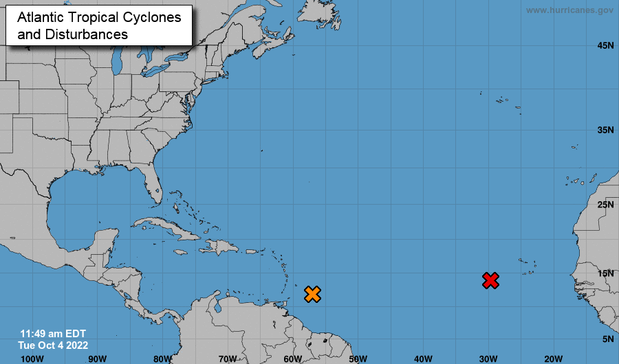 Moving forward across East Tennessee, high pressure sits to our north. As this shift east, warmer temperatures will advect in, allowing for highs to peak in the mid 70s tomorrow and near 80 on Thursday. This will be short lived though, as a cold front passes through Friday, bringing some of the coolest temperatures we have had since the Spring. This should be a dry front as well, meaning little to no rainfall chances locally, and mainly increased cloud cover for our northern counties. 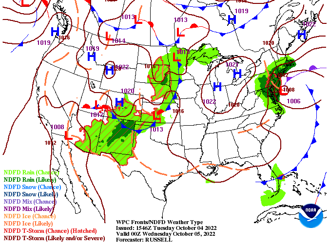 Checking out temperatures for Saturday and Sunday morning, it's going to be a chilly one. The cold front will allow for lows in the 40s Friday night and upper 30s Saturday night. Keep in mind this is for valley locations, those in the higher terrain will likely see the low 30s, with a few upper 20s not impossible. This is also a heads up to protect any tender/sensitive plants. Some frost is likely, which can kill off vegetation. 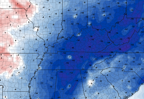 Other than the warming temperatures through Thursday and a quick drop off into the weekend, conditions remain rather quiet. Drought conditions will likely creep back in, which could lead to a risk of fire weather toward November. For now, things remain in tact but something we'll be watching for ahead. Pre-recorded for 5pm weather broadcast
|