|
Definitely a bit warmer out there than compared to this time yesterday, and that can be thanked due to high pressure moving off the coast. This has allowed for temperatures in the upper 40s and low 50s (noon) where highs find the mid 50s before the end of the day. Additionally, moisture is increasing across the area. Most should stay dry through this afternoon, but a few sprinkles can't be ruled out at times.  Looking at model guidance, our active streak of weather remains in tact. First up, a sliding cold front will bring widespread showers to the area overnight and early into Saturday. Most of the activity will hold off until late afternoon and evening, before showers pick up from west to east and continue through the night. Rainfall amounts will vary, with generally between a tenth to three tenths expected. Drier conditions then follow for the later half of Saturday, through Sunday, and a good chunk of Monday. Another longer lasting rain event then finds the area Monday night through mid week. We are still eyeing the flood potential but the axis of more consistent rain looks to have shifted a little further west. Nonetheless, something that could pose concern and something we will keep you updated on moving forward. Another opportunity will find us a week out (next Thursday to early weekend). Again, something that could pose concern given the series of rainy systems leading up to it.  Don't forget to check out our video forecast below for more information. Other than lingering cloud cover, most should veer on the dry side through much of the weekend. For those who are photogenic, don't forget to share your outdoor/ weather related pictures with us within the "Submissions" tab under the "News and More". Pre-recorded for 5pm weather broadcast
0 Comments
High clouds are passing through this afternoon, lending to partly cloudy skies and temperatures in the low 40s. We will warm a couple of more notches to top out in the mid to upper 40s, before additional cloud cover moves in overnight. This is all due to a cold front that will pass through Friday night and into Saturday morning. Showers are expected with this system, where briefly drier conditions follow Saturday afternoon to Sunday morning. Chances then return as a potentially long lasting rain event arrives late weekend and into next week. Looking at the long term outlook, the Climate Prediction Center has geared their forecast towards a higher probability for above average rainfall between the 6th and the 10th. 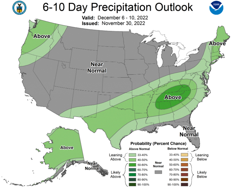 Essentially, the boundary that pulls through Friday night into Saturday will lift back north and stall out near the area. This will allow areas of low pressure to develop along it and bring multiple shower chances to the region. There is still quite a bit of uncertainty where this boundary sets up, as earlier guidance had this across Kentucky. The trend has been for a further south set up, but exactly where is still in question. Nonetheless, current data has this across the Tennessee valley so it warrants highlighting. Looking at ensemble guidance (multiple model runs synthesized into one), we could see over 3 to 4 inches of rainfall between now and the 7th (Wednesday). Of course, changes are likely but this will be something to monitor. 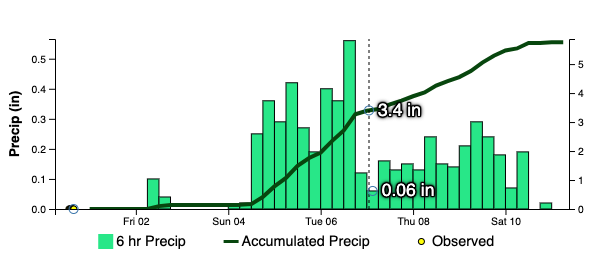 Furthermore, the Weather Prediction Center has released a rare day 5 slight risk of flash flooding. Typically these are in the shorter term (Day 1-3), but the data warrants highlighting the longer term risk. So what does all of this mean? Well, showers look likely but where the boundary and axis of showers develops is still a bit in question. More recent runs suggests across the Tennessee valley, and if that turns out to be the case, we could be in for flooding/ flash flooding concerns. Even with the dry/drought conditions we have been dealing with, 2-3 inches+ in a ~36 hour period could be a concern for flooding potential. The orientation and boundary would suggest training showers/storms as well (which is more favorable for flash flooding potential). We will keep an eye on things moving forward, but do keep in mind the various outcomes. 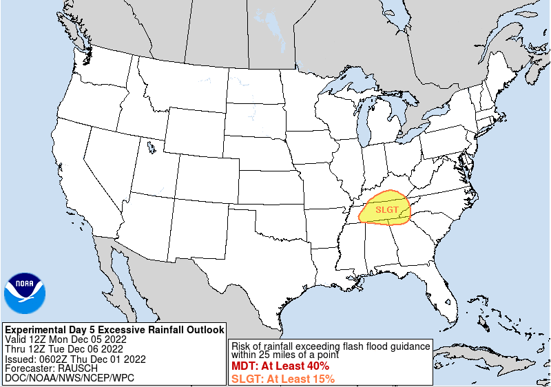 Other than showers tomorrow night into Saturday and again Sunday evening and through portions of next week, temperatures generally stay seasonable with highs Friday and the weekend in the 50s. Be sure to check back in moving forward, as there remains plenty of uncertainty with rainfall/any flooding potential next week (primarily Monday- Wednesday). Pre-recorded for 5pm weather broadcast
|