|
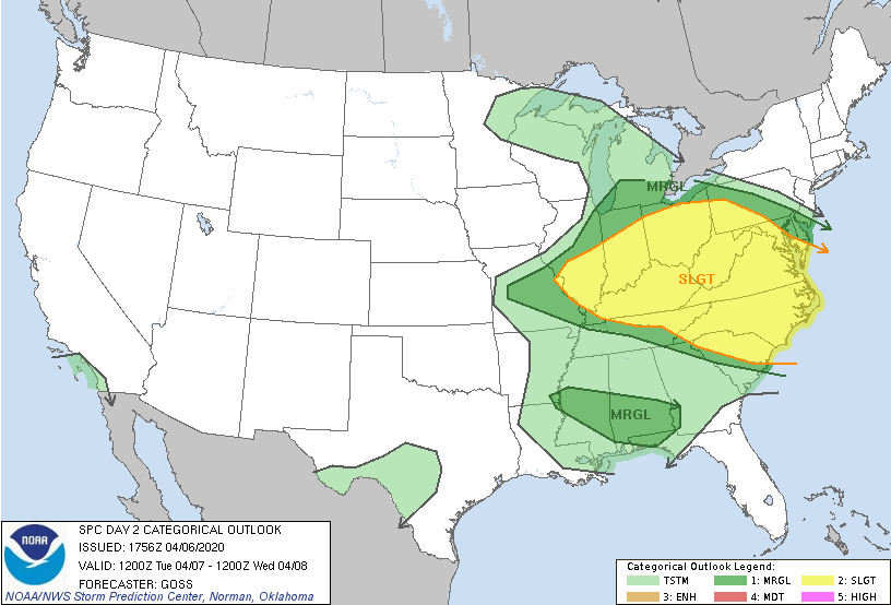
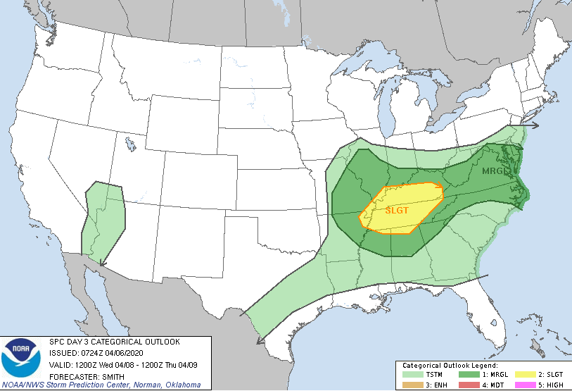
I hope everyone had a good Monday! The shot of Neyland Stadium below highlights today's beauty with few clouds and comfortable temperatures. Changes are on the way though for mid-week as showers and storms could impact the area in the days ahead. 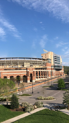 Imagery by Emily Green Starting with the day 2 SPC outlook (left), a slight risk is in effect for the northern and eastern half of our state. As we saw today, scattered showers will likely move through tomorrow afternoon and evening. With some instability in place, some of these could be strong to severe. Again into Wednesday (day 3 -- right), a slight risk remains as the main system begins to work in. The timing falls in the evening to overnight hours of Wednesday into Thursday with damaging winds and hail the main threats, but isolated spin-up also possible.
Model guidance depicts the scattered showers tomorrow afternoon and into Wednesday morning before a cold front works in from the west. If you notice toward the end of the gif, a line of showers works in from the west. Behind this, a cold front that will knock temperatures down to below average on Friday. Tomorrow will feel more like a late summer pop up shower/storm day with a chance for some to be severe. Wednesday night into Thursday will be a more typical setup with a strong jet, instability in place, and a trailing front. Nonetheless, be weather aware both days with an emphasis into Wednesday night.  Working into the end of the work week, much cooler air will push in. The cold front will begin to cool things off and clear things up Thursday, providing high's in the upper 50's on Friday. Sunny skies return as well but another round of isolated showers are possible the later part of the weekend.  That wraps it up for tonight....I apologize for the late post, but we'll be back to normal for tomorrow. Pay attention for any severe threats tomorrow afternoon and, as always, we'll keep you posted!
0 Comments
Another beautiful day is unfolding with sunny skies and high's around 70. Expect the dry conditions to continue into the weekend as well. A high pressure system will keep things at bay the next day or two, but changes arrive Sunday and early next week. 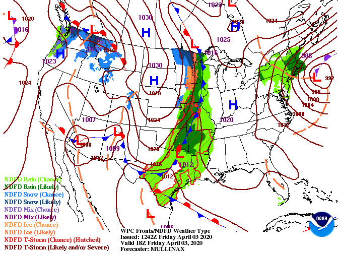 If you recall, we had high's in the low to mid 50's Tuesday and we are looking to be in the mid 70's Saturday and Sunday. The average for this time of the year is in the upper 60's, so we will be slightly above that as we work into the weekend.  A cold front will slowly makes its way east before breaking down late Saturday. An isolated shower or two is possible Sunday and Monday as another system to the south develops. We will see this system work in fully by Tuesday and early Wednesday before drier air follows the later portion of the week. Expect to stay on the drier side Sunday and Monday but we can't rule out a few isolated showers/storms.  If you have the opportunity to enjoy the sunshine and comfortable temperatures, I encourage everyone to do it! If you are active on social media, be sure to follow us @SecretCityWx. We will try to keep the boredom away with threads and weather updates. If you have anything you'd like to see, ask, or discuss, let us know! I hope you are enjoying your Thursday so far! It was another chilly start this morning with temperatures in the upper 30's to lower 40's. Luckily, we have begun to warm up late this morning with current temps in the mid 50's. If you check out the latest GOES-East view below, much of the southeast is having their fill of sunshine today. 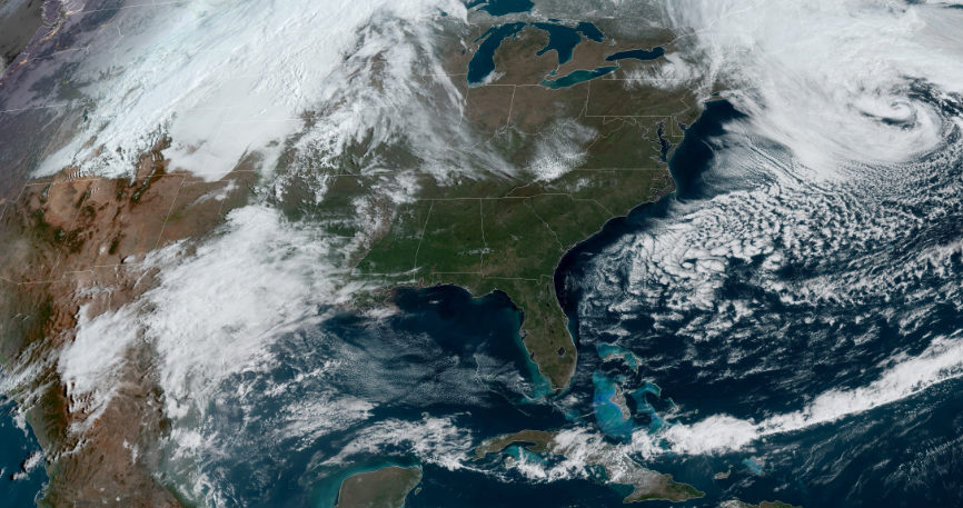 With a high pressure system stationed across the eastern half of the US, sunny skies will continue to stick around into Friday as well. We will gradually warm in the days ahead with high's tomorrow around 70 and low to mid 70's through the weekend.  With little to discuss the next couple of days, we will highlight the longer term changes. A system to the south and west is expected to develop and begin working in early next week. We will see an isolated shower or two Sunday and Monday before the main system arrives Tuesday and early Wednesday. 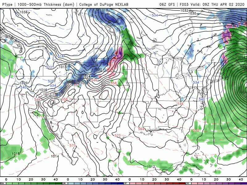 Sunny skies and comfortable temperatures stick around again tomorrow so go out and enjoy them! If you plan to hike, check out the lake (still very cold), or do something outdoors, share with us on Twitter/Facebook @SecretCityWx. Good afternoon! I hope you are staying warm once again today as high's will top out in the mid 50's. If we look into the Newfound Gap area this morning, a much different scene with a fresh 1-3" of snowfall across the area.  As we move into the days ahead, a high pressure system will clear things out making way for sunny skies and warming temperatures. We'll begin to inch our way back to average high's with tomorrow in the mid 60's. Warming temperatures continue into Friday as well with high's in the lower 70's. 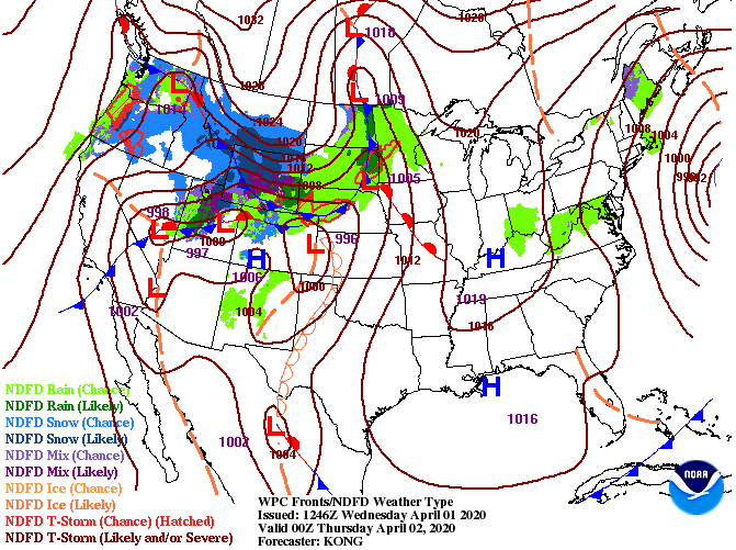 Model guidance shows a rather uneventful next few days as mostly sunny skies will be the main story across the region. As we work into the later half of Saturday and into the day Sunday, an isolated showers or two is possible across the area. Our best chance for showers doesn't return until Monday and early next week.  It is important to note areas of patchy frost are likely to develop overnight. If you have already started planting for the upcoming season, be sure to have a way to protect your plants tonight. Overnight low's in the valley will fall in the mid to upper 30's with the biggest concern for the higher elevations who will be around that freezing mark. If you get the opportunity, go out and enjoy a string of dry and sunny days. Today may be a bit chilly for some but Thursday and Friday will be beautiful with high's in the 60's and 70's. For a full graphical forecast, click "Weekly Forecast" at the top of our page. |