|
Cooler temperatures are continuing to funnel in this afternoon with nearly a 10 degree 24-hour temperature change expected within the next few hours. This will continue into your Saturday, as we will have high's in the mid 80's. 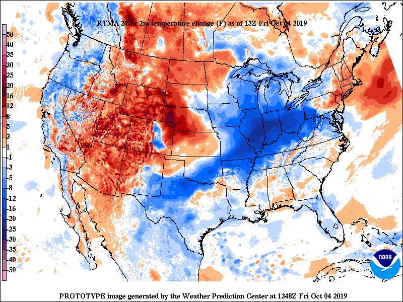 To our north in the Great Lakes region, a high pressure system will keep things dry across the area into Saturday. By Sunday, we will have another cold front approach, bringing with it showers and storms. This MUCH needed rainfall will arrive mainly in the overnight hours Sunday and into the early half of your Monday. We will quickly clear out, allowing for mostly sunny skies and highs in the mid 70's Tuesday. 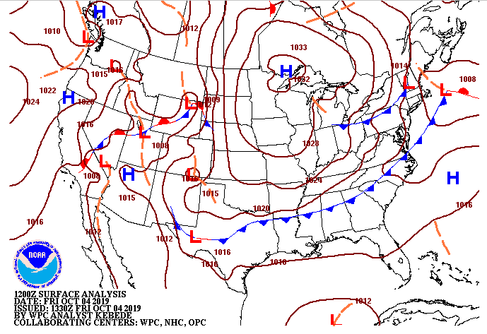 As expected, model guidance suggests dry conditions across the region through Saturday before the cold front and showers (out ahead of the front) arrive into Sunday. Latest models suggest around a half an inch for the valley through Monday afternoon, so we will take it! I know starting the work week rainy isn't ideal, but I am sure many of us will gladly accept it given the conditions we have been dealing with.  Thats all we have for your Friday, have a great weekend of "cooler" temperatures before Fall really makes its way in next week.
0 Comments
Happy Friday-eve to everyone. Another very hot afternoon expected with high's in the mid 90's. With the very warm and dry conditions we have had this past week, parts of the state are beginning to transition into a severe drought (Middle TN, NE TN, and Chattanooga area). Luckily, we will have our first real rain potential Sunday into Monday that will help combat the drought conditions we have been dealing with. 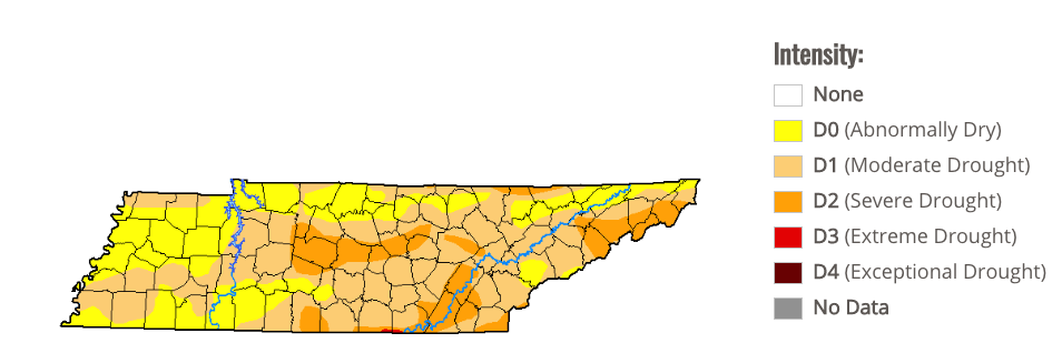 A cold front will slide through this evening leaving high's in the mid 80's Friday and Saturday. Working into your Sunday, the low pressure system (currently on the west coast) will move through north of the US, but provide us with a cold front. This front will bring shower and storm potential ahead of it, as well as much cooler temperatures (around the average). We are looking to start the work week next week with high's in the lower 70's.  There is nothing on model guidance that suggests drought conditions will get any better today, as we have very dry air aloft. This will begin breaking down into the weekend, as southern flow will return and with it, the rain chances by early next week.  Continue staying cool and hydrated this afternoon, as cooler temperatures and rainfall are expected in the forecast. Have a great day! Today will likely be another record-shattering high day with temperatures in the mid 90's. Luckily, we will have cooler temperatures move in Friday, allowing high's back in the low to mid 80's. Even better news, the low pressure system sitting off of the western coast will meander east, providing near to below average temperatures and rain chances, as we get into the beginning of next week. 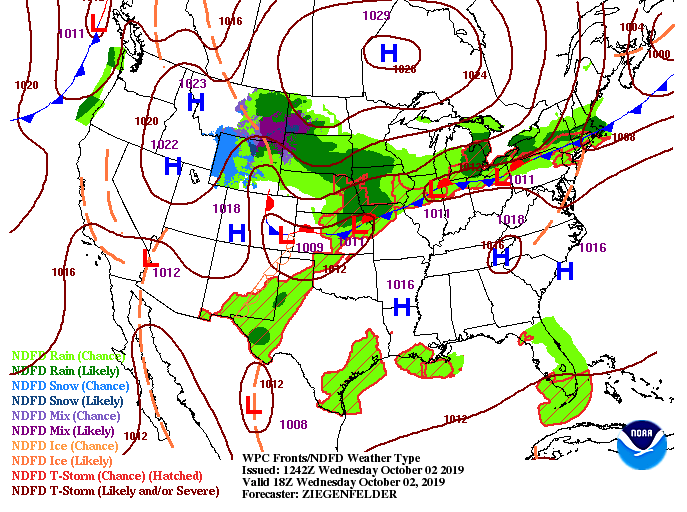 So, taking a look at next week to get a little sneak peak of what we could see, this is for Monday afternoon. High's expected to be in the lower 70's with rain chances likely, as well. We are FINALLY transitioning toward a fall-like pattern, so 90 degree days will likely be behind us after tomorrow. Nonetheless, long term we will likely stay above the average into the later half of October, but relative to what we have had, cooler temperatures in the forecast.  Not much activity expected with the latest model guidance, as the high pressure system across the area will lock in dry conditions and hot temps. This will continue into Thursday too, with rain chances not arriving until the afternoon/overnight hours Sunday and into Monday.  Thats all we have for your Wednesday, but better conditions (closer to average) are on the way! Be patient and stay cool and hydrated in the mean time. Happy first day of October! It is feeling a lot more like the first day of August though, as high's this afternoon will again be in the low to mid 90's. Looking below, this is the 500mb height level (~16,000-20,000ft) in the air. This graphic is showing where pressures are higher (associated with warmer temperatures) or lower (colder temperatures) all in comparison to the average sea-level pressure. As you can depict, VERY warm across much of the eastern half of the US due to strong ridging in the area. Luckily, we will have a trough develop and move through this weekend bringing the chance for some much needed showers next week. 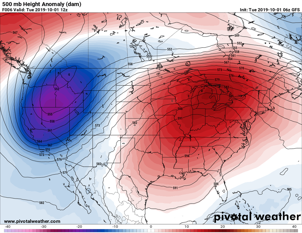 The latest from the CPC (Climate Prediction Center) shows those warm temperatures sticking around into mid October (and likely into November) with above average temperatures. Don't let this graphic discourage you though, as average for this time of the year is the upper 70's and we will likely be in the low to mid 80's the next couple of weeks. We will stay warmer than average, but relative to how it has been, we will be "cooler" long term. The 8-14 day outlook suggests slightly above average precipitation as well, which is good news for our area. As I mentioned, we will likely see some rain showers next week before the graphic below suggests slight above average into mid-October. 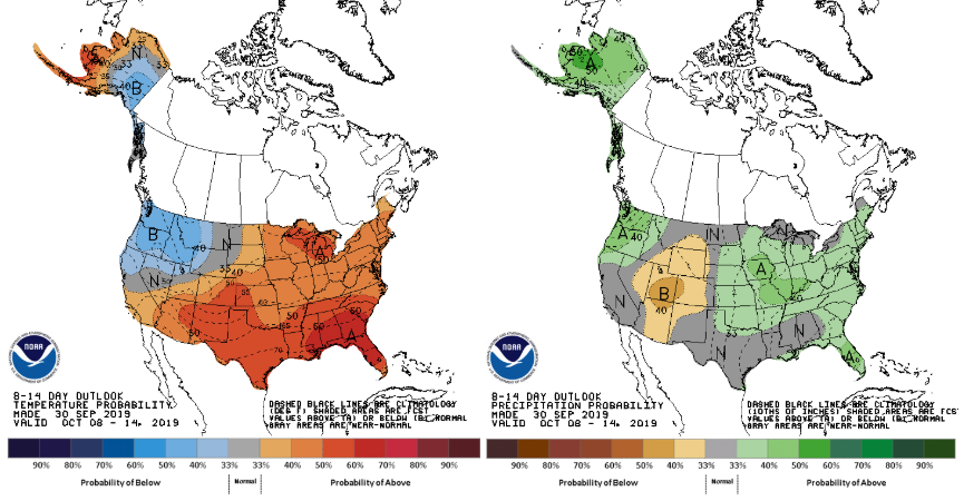 Little to discuss with the model guidance. We have a low to our north and west, providing showers in the Ohio and Great lakes region (we will stay dry). This will continue sliding through allowing for a cold front to move through east TN and those cooler temperatures to follow into Friday and the weekend.  There is your Tuesday forecast, so have a wonderful day and remember your heat safety through Thursday as we will remain hot the next couple of days. |