|
Happy St. Patrick's Day to everyone! I hope your day is a bit more lucky than the weather we have been having. If you take a look below, southwest flow is beginning to dominate from western Texas to New England. This will allow for warming temperatures the next couple of days.  Looking at the latest surface map, remnant showers are working through the valley now before mostly cloudy skies return this afternoon. A high pressure system to the north will keep things mostly dry this afternoon to Wednesday then scattered showers return Wednesday night and Thursday. The main focus will be on Friday afternoon as a system (currently in the Midwest) could bring stronger showers and storms.  The last of the showers are working out now leaving mostly cloudy skies the remainder of today and into Wednesday. By tomorrow evening, additional scattered showers will work in and through Thursday. By Friday, a low pressure system will arrive bringing the chance for some heavier showers and storms. Though the SPC hasn't released an outlook for day 4, I anticipate a marginal to slight risk will cover the region. Models seem to be in agreement that the bulk of "strong stuff" will stay to the north but rounds of heavier showers, embedded thunder, and minor flooding is possible.  Through 11am today we have recorded 0.58" here at the office with mostly cloudy skies beginning to work in now. The graphic below depicts expected rain totals now through Friday afternoon. As you can tell, the bulk of rainfall will stay to the north and west with the heaviest rainfall amounts coming on Friday. 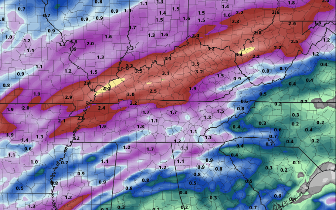 I hope everyone has a safe St. Patrick's day and stay dry this afternoon! We'll continue to monitor any severe weather potential for Friday.
0 Comments
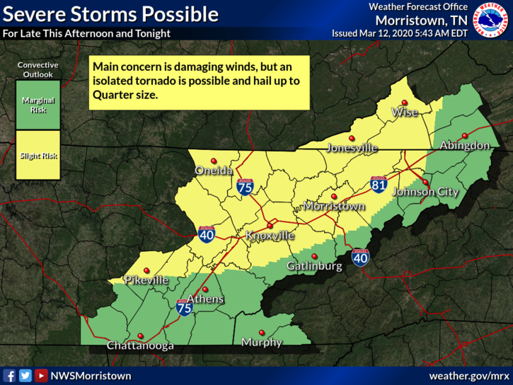
Another chilly start this morning with temperatures into the 40's but warmer air is on the way. With another active week in store, southern flow will help draw in warm Gulf temperatures as well as that moisture much of this week.  If we take a look at the latest surface map, you can see the next weather maker lies just to the west. Showers are expected to work in overnight tonight and continue until early tomorrow afternoon. We'll begin drying back out but cloudy skies will stick around for the second half of Tuesday. High's will begin warming as well, in the mid 60's tomorrow, with mid 70's for Wednesday and Thursday. Keep in mind the average temperature in Knoxville is 62 this time of the year and we could be pushing 80 as we work into Thursday. 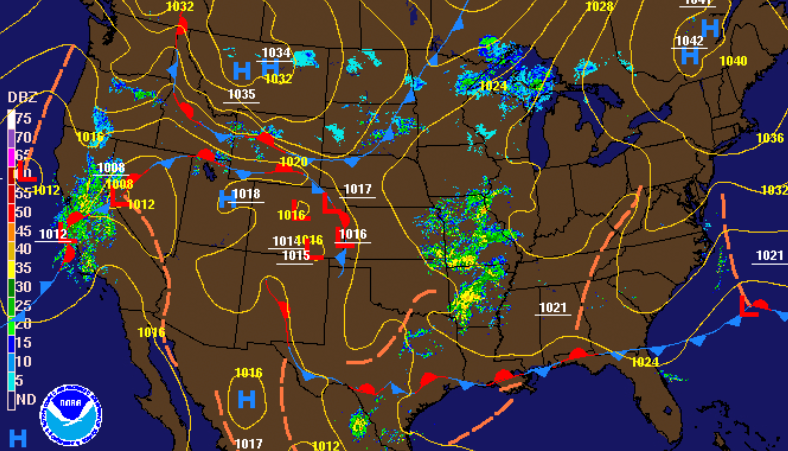 For your week ahead, very similar to last week. A mix of scattered showers and cloud cover through the next several days. The best day for any outdoor activity will be tomorrow afternoon and Wednesday before scattered showers work back in for Thursday. Something we'll be eying is the chance for heavier showers and storms for Friday. A strong cold front will work through the Midwest providing the chance for heavy showers and thunderstorms Friday and early Saturday.  This active pattern looks to continue for sometime so prepare for more gloomy and wet days. We'll continue to eye any severe weather chances for Friday, but until then, stay dry! Happy Friday to you! Showers have been limited to southern Tennessee this morning but by this afternoon, we will all be mostly cloudy. Just to our west is a cold front that will work in overnight and through Saturday. This is a weak front but it will still provide some cooler air over the next 24 hours.  As mentioned, the cold front will work in overnight tonight providing low's in the low to mid 40's. As we work ahead, we'll stay dry for the start of Saturday with a system working through by the afternoon and overnight hours. Scattered showers will continue into Sunday before we dry back out Sunday afternoon and much of Monday. 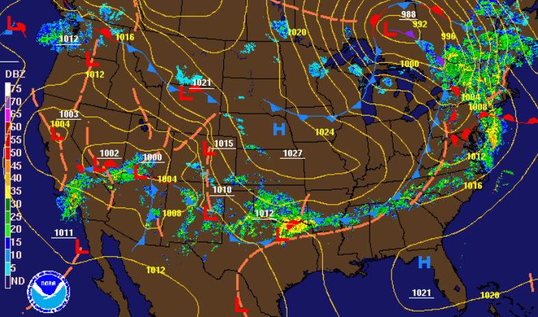 Very similar to this week, showers will be light and scattered for the weekend and beginning of next week. As model guidance suggests, the first half of the day Saturday will be mostly cloudy with showers arriving in the PM hours. These will remain scattered into Sunday before clearing back out by the afternoon. Realistically, expect the chance for showers each day next week with limited sunshine potential. Again, this next week won't be a washout but more of an annoyance with the scattered showers.  That'll wrap it up for this week but enjoy your weekend! Make use of the first half of Saturday before rain chances increase in the afternoon. So far today, a few scattered showers have worked through (mainly to the south). As you can see below, the SPC has placed us in a slight risk for severe weather. Just to our north and west, western KY and TN are under an Enhanced risk (3/5). The main threat here at home will be damaging winds but isolated tornadoes and hail up to a quarter in size are possible.
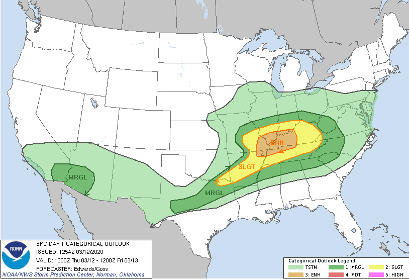
As we look into this afternoon, a warm front will be moving through the area. Just like it is described, the warm front will pull in warm moist air from the Gulf (high dew points). Though the severe threat will stay mainly to our west, this is one of the parameters we look at for severe weather. Moving ahead, a cold front will slide through tomorrow providing cooler air for the start of the weekend. 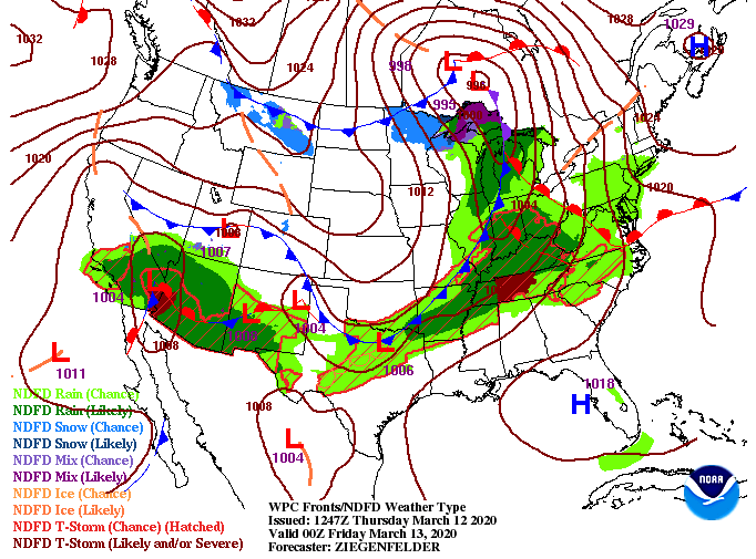 Looking at the latest model guidance, scattered showers will continue working through this afternoon. By the later half of the day strong storms will begin developing in central Kentucky and working east. If you notice toward the end of the gif, a bowing-like line of showers/storms is working through western TN. This is the line that poses the best risk for severe weather here at home. Luckily, with its arrival in the evening/overnight hours, the system will be dying down. If storms do stay organized long enough, we could see damaging winds, isolated tornadoes, and small hail for the northern half of east TN.  Stay up to date the second half of today through our Twitter and Facebook as we'll keep you posted. Also be sure to have a way to receive alerts from the NWS if watches/warnings are issued this evening. Stay weather aware and have a good one! Check out the latest view from the Stansfield's cam. Not only is it finally not raining, but some peaks of sunshine are shinning through; take advantage! Showers will return tomorrow and parts of Friday and again throughout the weekend.  The latest from the SPC shows severe potential for western TN and KY tomorrow afternoon and evening with only a marginal risk for our neck of the woods. The bulk of heavy showers and storms will stay to the north but damaging winds are something we'll be watching for here at home. As with all severe weather outlooks, isolated spin-up is something we can't forget about but potential is low. 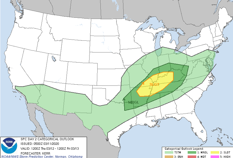 Along with the SPC outlook, the WPC has provided a marginal risk of flash flooding across Tennessee and Kentucky. Isolated flash flooding is possible in heavier showers tomorrow, so be weary if in flood prone areas. 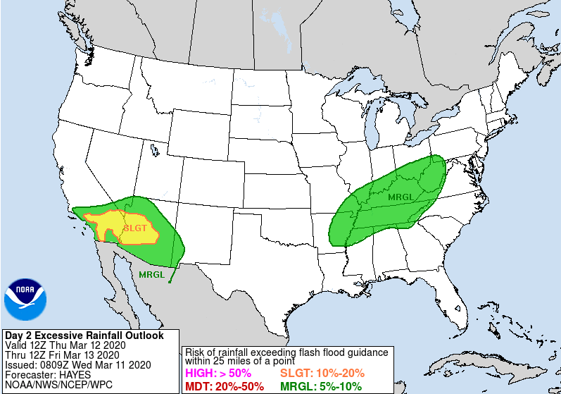 The latest model guidance runs shows the waves of showers and storms working throughout tomorrow and Friday. Friday afternoon we will begin to dry back out, continuing into Saturday morning. Unfortunately, another round of shower activity arrives for Sunday and early next week. As mentioned yesterday, this pattern of scattered showers looks to stick around for the next several days so keep the umbrellas handy.  That concludes the forecast for today but be sure to check in for the latest in regard to any severe potential tomorrow afternoon. Shower activity has been limited to the AM hours so far today. Another round of showers is likely working into the afternoon and evening ahead of a weak cold front moving through. So far, we have picked up almost 0.25" of rainfall here at the office. 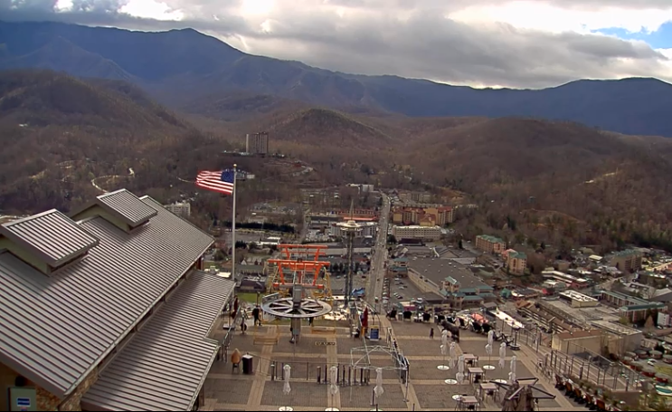 Looking at what's to come, we'll dry out tonight and much of Wednesday before showers return Wednesday night. Rounds of scattered showers will work through Thursday and Friday before another break comes Saturday morning and into the afternoon. Once again, though, showers return Saturday night and into Sunday.  Though model guidance paints a more dramatic story, totals will stay limited to 1-3" through Friday afternoon. These showers, as mentioned yesterday, will be more of a pester than anything else. Nonetheless, keep the umbrellas handy the next several days. Temperatures will stay Spring-like in the 60's through much of this week. 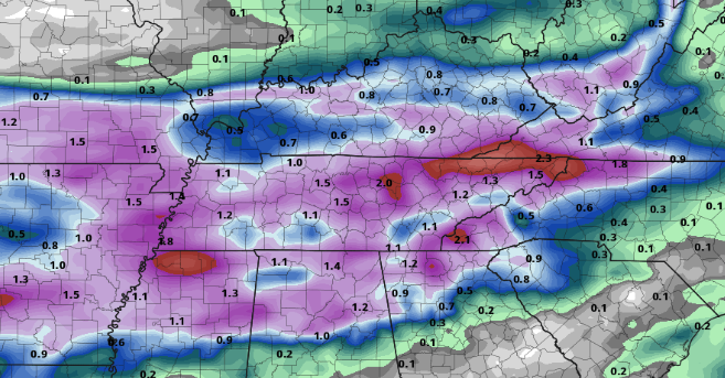 Though shower activity is likely much of this week, there are some opportunities to enjoy the outdoors (Wednesday & parts of Saturday). Stay dry as this pattern looks to stick around for some time. What a beautiful weekend we had! With a high pressure system in place, temperatures have been quite warm for much of the eastern half of the US. For you Spring lovers, temperatures will remain above average (in the 60's) throughout this week. As for today, we'll stay dry with cloud cover increasing throughout the afternoon.  Enjoy the lack of rain today before showers return into Tuesday. Looking below, our next system lies just to the west. Rain will begin working in overnight and through Tuesday before moving out by the afternoon and evening hours. 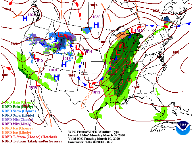 Model guidance tells the story of shower activity this week. Rounds of showers on and off each day will be more of an annoyance than a washout. As you can see, showers will thin out by tomorrow evening before another round returns into Wednesday. Much of the same can be said for Thursday and Friday as well.  Even though shower activity is likely each day, it won't be a wash out for the area. Rounds of scattered showers will be the main story this week with totals between 1 and 3 inches. This week will be more of a pester with the showers than it will be a washout. 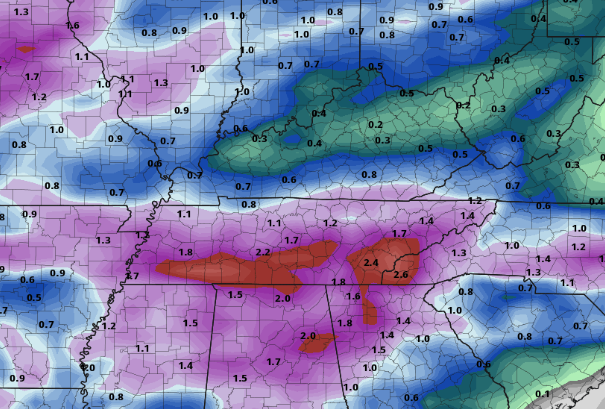 That concludes the forecast for today but keep the umbrellas handy the next couple of days, scattered showers stick around much of this week. Shower activity today will stay contained to northern TN and the higher elevations (east). Cloud cover will gradually thin out this afternoon, providing partly cloudy skies. A cold front has started to work through now keeping temperatures into the lower 40's, but by 5 o' clock most will be in the upper 30's. It has also been breezy through the morning hours with gusts up to 20 mph at times. Wind chills are in the mid 30's, so stay warm! 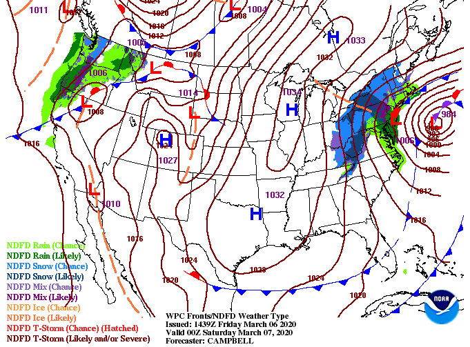 To begin the weekend, we will be beautiful. Temperatures will remain below average in the lower 50's but lots of sunshine will make things feel a bit more comfortable. Sunday will be the best day for outdoor activities with high's in the lower 60's, but lets face it, both days will be gorgeous.  With cooler air working through today, a high pressure system will build in behind gradually warming things up this weekend. The latest data suggests Spring could be starting a bit early given the latest patterns we've had and those to come. Speaking of Spring, the first day will be March 19th at 11:50 PM (EDT). This will be the earliest Spring start in 124 years. Working overnight Sunday and into Monday, cloud cover will increase with showers by Monday night. Next week looks to be another soggy one with showers likely Tuesday through Thursday.  Take advantage of the weekend ahead and enjoy some sunshine and outdoor activities. Be sure to share your adventures with us by sending pictures to SecretCityWx@aol.com or tagging us on social media (Twitter & Facebook : @SecretCityWx) Good afternoon! It has been rather uneventful for many (as expected) with only a few showers working through parts of Chattanooga this morning. As we work ahead, cooler air will arrive Friday morning. As you can see below, a low to the west of the Great Lakes will move east today providing cooler air for our region. 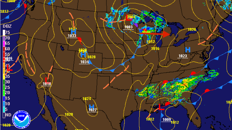 If we look into model guidance, we will start the morning into the upper 30's and lower 40's before cooler air keeps temperatures around that mark for the day. If you notice into eastern TN and eastern KY, temperatures will stay around freezing as that cold front works through. With cooler temperatures in place for the higher elevations, these areas could see some snowfall through the day.  Though any moisture here in the valley looks bleak, a stray shower or some mixing is possible tomorrow morning. By the afternoon we'll clear out to be partly cloudy with temperatures in the mid 40's. As for the Smokies, snowfall is more likely with temperatures around freezing much of the day. Keep in mind along with cooler temperatures will be breezy conditions as well. Winds between 5 and 15 mph could make temperatures feel in the 30's at times. 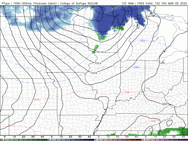 Be sure to bundle up tomorrow as cooler air moves back in. High's will be 10 degrees below average for this time of the year but warmer air moves back in for the weekend. If you haven't had the opportunity, be sure to check out and download this year's East Tennessee Almanac at SecretCityWeather.com/Almanac. This morning has been comfortable with temperatures in the 50's and a mix of sunshine and cloud cover. Unfortunately, clouds will increase this afternoon with a chance for showers tomorrow morning.  Stansfield's Webcam The current surface map shows that system bringing lots of moisture to the southern states. As the low tracks north and east, it will clip the southeastern corner of Tennessee. Rainfall will be light and quick moving with clearer skies back in the forecast for Friday. 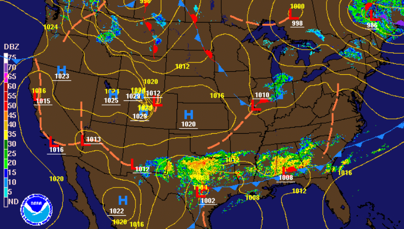 As this system works northeast, showers will stay mainly south of I-40 and east of I-75 tomorrow. This isn't to say those in Oak Ridge, Clinton, LaFollete, and to the north won't see any showers, but the potential for activity is low. As we work into Friday, sunnier skies work in by the afternoon with a beautiful weekend to follow.  Looking more in depth at the cold front Friday, highs will be on the cooler side across the region into the mid to upper 40's. With sunshine likely in the afternoon, that could allow for surface temperatures to feel a bit warmer (upper 40's) than what model guidance is suggesting. Nonetheless, cooler air will be around Friday before we warm into the weekend. 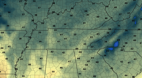 That will wrap it up for today but enjoy the comfortable temperatures before cooler air arrives Friday. |